TopoQuest Logo
Do you find TopoQuest useful?
Help keep TopoQuest running and adding new maps/features by donating!
Bitcoin:  19c7KJd3qBynnjoSw5npx9KScwjBe4ifkT
Litecoin:  LXs6TkuXGGXo1vDsWCkWVdjQX94eUKd6ui
Home View Maps Find Maps Find Places Resources & Links


Ramona, California Topographic Map

USGS Map Title: Ramona, CA
USGS Map MRC: 33116A7
DRG (GeoTIFF) Download: o33116a7.tif


Neighboring USGS Topographic Map Quads:


  Rodriguez Mountain, CA  
33116B8
 

  Mesa Grande, CA  
33116B7
 

  Warners Ranch, CA  
33116B6
 

  San Pasqual, CA  
33116A8
 

  Ramona, CA  
33116A7
 

  Santa Ysabel, CA  
33116A6
 

  San Vicente Reservoir, CA  
32116H8
 

  El Cajon Mountain, CA  
32116H7
 

  Tule Springs, CA  
32116H6


Map MRC Location:

N34°
W117°
N34°
W116°
H8 H7 H6 H5 H4 H3 H2 H1
G8 G7 G6 G5 G4 G3 G2 G1
F8 F7 F6 F5 F4 F3 F2 F1
E8 E7 E6 E5 E4 E3 E2 E1
D8 D7 D6 D5 D4 D3 D2 D1
C8 C7 C6 C5 C4 C3 C2 C1
B8 B7 B6 B5 B4 B3 B2 B1
A8 A7 A6 A5 A4 A3 A2 A1
N33°
W117°
N33°
W116°

Ramona, CA USGS 1:24K Topographic Map Preview:
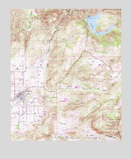
Ramona, CA USGS Topographic Map
Click on map above to begin viewing in our Map Viewer.

This topographic map contains these locations and features:
Feature Name Type Latitude Longitude GNIS ID View Map
Ballena CemeteryCemeteryN33.0656°W116.7717°2773337View Map
Ballena ValleyValleyN33.0570°W116.7634°269657View Map
Barnett Elementary SchoolSchoolN33.0173°W116.8106°1868953View Map
Bassett RanchLocaleN33.0156°W116.8184°269705View Map
Bloomdale CreekStreamN33.1245°W116.7714°269917View Map
CAL FIRE Ramona Fire Station 80BuildingN33.0366°W116.8652°2665110View Map
CAL FIRE Ramona Fire Station 81BuildingN33.0007°W116.8002°2665109View Map
Calvary ChapelChurchN33.0439°W116.8634°1868956View Map
Collier ParkParkN33.0423°W116.8606°270564View Map
First Church of Christ ScientistChurchN33.0456°W116.8603°1868962View Map
First Congregational ChurchChurchN33.0428°W116.8645°1868963View Map
Flying T Ranch AirportAirportN33.0691°W116.7529°1653848View Map
Goose ValleyValleyN33.0578°W116.8528°271362View Map
Goose Valley Ranger StationLocaleN33.0737°W116.8453°271363View Map
Grace Community ChurchChurchN33.0309°W116.8656°1868965View Map
Hatfield CreekStreamN33.0578°W116.8528°243273View Map
Himmel CanyonValleyN33.0012°W116.7575°271583View Map
Homestar Shopping CenterLocaleN33.0403°W116.8728°1868967View Map
Immaculate Heart of Mary Catholic ChurchChurchN33.0445°W116.8603°1868968View Map
Inter Mountain Fire and Rescue DepartmentBuildingN33.0734°W116.7685°2665333View Map
James Dukes Elementary SchoolSchoolN33.0084°W116.7922°1868969View Map
Lake SutherlandReservoirN33.1103°W116.7783°273976View Map
Lutheran Church of RamonaChurchN33.0373°W116.8736°1868980View Map
Mesa Grande ReservationCivilN33.0887°W116.7519°2419013View Map
Montecito High SchoolSchoolN33.0423°W116.8650°274270View Map
Mount GowerSummitN33.0164°W116.7625°271382View Map
Mount Gower Open Space PreserveParkN33.0200°W116.7814°1868982View Map
Neighborhood Baptist ChurchChurchN33.0253°W116.8561°1868983View Map
Nuevo Memory GardensCemeteryN33.0576°W116.8640°1868981View Map
Olive Pierce Middle SchoolSchoolN33.0270°W116.8725°1868984View Map
Orosco Truck TrailTrailN33.1164°W116.8692°269417View Map
Palomar Ranger StationBuildingN33.0732°W116.8453°2548722View Map
Pamo Ranger Station (historical)LocaleN33.1181°W116.8500°1701238View Map
Pamo ValleyValleyN33.1062°W116.8581°272862View Map
Pine Hill Egg RanchLocaleN33.0725°W116.7764°2677497View Map
RamonaPopulated PlaceN33.0417°W116.8681°1652781View Map
Ramona Branch San Diego County LibraryBuildingN33.0395°W116.8742°1868986View Map
Ramona Chamber of CommerceBuildingN33.0398°W116.8697°1868987View Map
Ramona Community CenterBuildingN33.0512°W116.8586°1868988View Map
Ramona Community ParkParkN33.0487°W116.8636°1868989View Map
Ramona DivisionCivilN33.0338°W116.8502°1935260View Map
Ramona Duck FarmLocaleN33.0683°W116.8581°2703684View Map
Ramona Elementary SchoolSchoolN33.0423°W116.8653°1868990View Map
Ramona First Baptist ChurchChurchN33.0414°W116.8664°1868991View Map
Ramona High SchoolSchoolN33.0273°W116.8692°1868992View Map
Ramona LandfillLocaleN33.0853°W116.8633°2708139View Map
Ramona Shopping CenterLocaleN33.0384°W116.8739°1868994View Map
Rincon RefugioLocaleN33.0789°W116.8384°1701243View Map
Saint Marys in the Valley Episcopal ChurchChurchN33.0345°W116.8653°1868997View Map
San Diego Country EstatesPopulated PlaceN33.0067°W116.7836°1867055View Map
San Diego Country Estates Census Designated PlaceCensusN33.0093°W116.7875°2409252View Map
San Diego CountyCivilN33.0282°W116.7702°277301View Map
San Vincente Community ChurchChurchN33.0084°W116.7914°1868999View Map
San Vincente Country Club and Golf CourseLocaleN33.0028°W116.8161°1869000View Map
Santa Teresa ValleyValleyN33.0703°W116.7961°273569View Map
Santa Ysabel Truck TrailTrailN33.1239°W116.8131°273574View Map
Spangler PeakSummitN33.0050°W116.8334°273856View Map
Sutherland 8-010 DamDamN33.1184°W116.7870°1663338View Map
Sutherland DamDamN33.1184°W116.7870°1701246View Map
Swartz CanyonValleyN33.0017°W116.8028°273980View Map
Temescal CreekStreamN33.1200°W116.8525°274059View Map
The Church of Jesus Christ of Latter Day SaintsChurchN33.0403°W116.8653°1868957View Map
Valle De Los AmigosValleyN33.0650°W116.8464°274300View Map
Wash Hollow CreekStreamN33.0506°W116.8092°274386View Map
Whale MountainSummitN33.0750°W116.7609°274455View Map

Note: Coordinates in the location and feature list above are referenced to NAD83 datum.


Copyright (C) 2008-2024 Ryan Niemi / Sunset Dynamics ... All Rights Reserved