TopoQuest Logo
Do you find TopoQuest useful?
Help keep TopoQuest running and adding new maps/features by donating!
Bitcoin:  19c7KJd3qBynnjoSw5npx9KScwjBe4ifkT
Litecoin:  LXs6TkuXGGXo1vDsWCkWVdjQX94eUKd6ui
Home View Maps Find Maps Find Places Resources & Links


El Jardin, Texas Topographic Map

USGS Map Title: El Jardin, TX
USGS Map MRC: 26097E5
DRG (GeoTIFF) Download: o26097e5.tif


Neighboring USGS Topographic Map Quads:


  Rosita Lake, TX  
26097F6
 

  Rosita Lake NE, TX  
26097F5
 

  South of Potrero Lopeno NW, TX  
26097F4
 

  San Perlita North, TX  
26097E6
 

  El Jardin, TX  
26097E5
 

  Port Mansfield, TX  
26097E4
 

  San Perlita South, TX  
26097D6
 

  Willamar, TX  
26097D5
 

  Hawk Island, TX  
26097D4


Map MRC Location:

N27°
W98°
N27°
W97°
H8 H7 H6 H5 H4 H3 H2 H1
G8 G7 G6 G5 G4 G3 G2 G1
F8 F7 F6 F5 F4 F3 F2 F1
E8 E7 E6 E5 E4 E3 E2 E1
D8 D7 D6 D5 D4 D3 D2 D1
C8 C7 C6 C5 C4 C3 C2 C1
B8 B7 B6 B5 B4 B3 B2 B1
A8 A7 A6 A5 A4 A3 A2 A1
N26°
W98°
N26°
W97°

El Jardin, TX USGS 1:24K Topographic Map Preview:
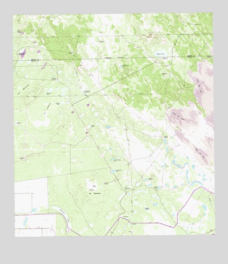
El Jardin, TX USGS Topographic Map
Click on map above to begin viewing in our Map Viewer.

This topographic map contains these locations and features:
Feature Name Type Latitude Longitude GNIS ID View Map
Beto TankReservoirN26.5112°W97.5583°1330539View Map
Botellas WindmillLocaleN26.6037°W97.5878°1331105View Map
Buena Vista WindmillLocaleN26.6165°W97.6217°1331540View Map
Canteras Artesian WellWellN26.6098°W97.5703°1332113View Map
Catanes TankSwampN26.5757°W97.5949°1332323View Map
Cleo TankReservoirN26.5069°W97.5529°1332979View Map
Coyotes TankReservoirN26.5621°W97.5776°1333609View Map
Delfino WindmillLocaleN26.5153°W97.5433°1334240View Map
Desierto WindmillLocaleN26.6006°W97.5019°1334282View Map
Don Delfino TankReservoirN26.5366°W97.5623°1334476View Map
Dos Mesquites Artesian WellWellN26.5815°W97.5803°1334510View Map
El Golpe TankReservoirN26.5318°W97.5431°1335192View Map
El JardinFlatN26.5723°W97.6042°1335198View Map
El Jardin TankReservoirN26.5807°W97.6054°1335200View Map
Estacas LakeLakeN26.5123°W97.5933°1335522View Map
Flor de Mayo TankReservoirN26.5432°W97.5636°1335967View Map
Jaboncillos WellWellN26.6187°W97.5117°1338545View Map
La Mar Artesian WellWellN26.5640°W97.6239°1339349View Map
La Sal Artesian WellWellN26.6003°W97.5314°1339405View Map
Laguna la SalLakeN26.6028°W97.5322°1339457View Map
Los BecerrosFlatN26.5823°W97.6203°1340573View Map
Marcelina Artesian WellWellN26.5887°W97.5980°1340930View Map
Monterrey Artesian WellWellN26.5265°W97.5783°1341824View Map
Monterrey WindmillLocaleN26.5303°W97.5689°1341828View Map
Perico WindmillLocaleN26.5912°W97.5300°1343855View Map
Plan de MonterreyFlatN26.5270°W97.5753°1344164View Map
San Andreas WindmillLocaleN26.5442°W97.6186°1346297View Map
San Francisco RanchLocaleN26.6034°W97.6225°1346345View Map
Telephone Artesian WellWellN26.5962°W97.5561°1348339View Map
Tenerias WindmillLocaleN26.5553°W97.5311°1348359View Map
Venado TankReservoirN26.5274°W97.5349°1349232View Map

Note: Coordinates in the location and feature list above are referenced to NAD83 datum.


Copyright (C) 2008-2024 Ryan Niemi / Sunset Dynamics ... All Rights Reserved