TopoQuest Logo
Do you find TopoQuest useful?
Help keep TopoQuest running and adding new maps/features by donating!
Bitcoin:  19c7KJd3qBynnjoSw5npx9KScwjBe4ifkT
Litecoin:  LXs6TkuXGGXo1vDsWCkWVdjQX94eUKd6ui
Home View Maps Find Maps Find Places Resources & Links


Arena, Wisconsin Topographic Map

USGS Map Title: Arena, WI
USGS Map MRC: 43089B8
DRG (GeoTIFF) Download: o43089b8.tif


Neighboring USGS Topographic Map Quads:


  Plain, WI  
43090C1
 

  Black Hawk, WI  
43089C8
 

  Sauk Prairie, WI  
43089C7
 

  Spring Green, WI  
43090B1
 

  Arena, WI  
43089B8
 

  Mazomanie, WI  
43089B7
 

  Pleasant Ridge, WI  
43090A1
 

  Barneveld, WI  
43089A8
 

  Blue Mounds, WI  
43089A7


Map MRC Location:

N44°
W90°
N44°
W89°
H8 H7 H6 H5 H4 H3 H2 H1
G8 G7 G6 G5 G4 G3 G2 G1
F8 F7 F6 F5 F4 F3 F2 F1
E8 E7 E6 E5 E4 E3 E2 E1
D8 D7 D6 D5 D4 D3 D2 D1
C8 C7 C6 C5 C4 C3 C2 C1
B8 B7 B6 B5 B4 B3 B2 B1
A8 A7 A6 A5 A4 A3 A2 A1
N43°
W90°
N43°
W89°

Arena, WI USGS 1:24K Topographic Map Preview:
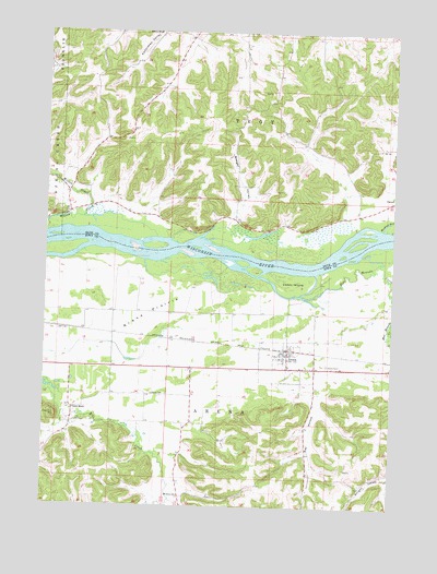
Arena, WI USGS Topographic Map
Click on map above to begin viewing in our Map Viewer.

This topographic map contains these locations and features:
Feature Name Type Latitude Longitude GNIS ID View Map
ArenaPopulated PlaceN43.1655°W89.9129°1560929View Map
Arena CemeteryCemeteryN43.1627°W89.8978°1560930View Map
Arena Community Elementary SchoolSchoolN43.1625°W89.9120°1837764View Map
Arena Fire Department / Emergency Medical ServicesBuildingN43.1628°W89.8999°2697768View Map
Arena Pines-Sand Barrens State Natural AreaParkN43.1797°W89.9304°1988887View Map
Arena Police DepartmentBuildingN43.1633°W89.9186°2759555View Map
Arena PrairieFlatN43.1755°W89.9632°1560931View Map
Badger ValleyValleyN43.2007°W89.9338°1561079View Map
Blue Mounds CreekStreamN43.1875°W89.9312°1561948View Map
CassellPopulated PlaceN43.2067°W89.8751°1577539View Map
Cedar IslandIslandN43.1844°W89.9115°1562846View Map
Coon RockPopulated PlaceN43.1508°W89.9896°1577556View Map
Davis CemeteryCemeteryN43.1546°W89.9607°1563730View Map
Muskrat RunStreamN43.1986°W89.8796°1570075View Map
Point BluffCliffN43.2492°W89.9665°1571716View Map
Ray HollowValleyN43.1508°W89.9019°1572110View Map
Saint Johns ChurchChurchN43.1278°W89.9507°1573078View Map
Town of ArenaCivilN43.1332°W89.9352°1582708View Map
Town of TroyCivilN43.2432°W89.9169°1584298View Map
Village of ArenaCivilN43.1637°W89.9103°1582707View Map

Note: Coordinates in the location and feature list above are referenced to NAD83 datum.


Copyright (C) 2008-2024 Ryan Niemi / Sunset Dynamics ... All Rights Reserved