TopoQuest Logo
Do you find TopoQuest useful?
Help keep TopoQuest running and adding new maps/features by donating!
Bitcoin:  19c7KJd3qBynnjoSw5npx9KScwjBe4ifkT
Litecoin:  LXs6TkuXGGXo1vDsWCkWVdjQX94eUKd6ui
Home View Maps Find Maps Find Places Resources & Links


Plain, Wisconsin Topographic Map

USGS Map Title: Plain, WI
USGS Map MRC: 43090C1
DRG (GeoTIFF) Download: o43090c1.tif


Neighboring USGS Topographic Map Quads:


  Lime Ridge, WI  
43090D2
 

  Loganville, WI  
43090D1
 

  Rock Springs, WI  
43089D8
 

  Bear Valley, WI  
43090C2
 

  Plain, WI  
43090C1
 

  Black Hawk, WI  
43089C8
 

  Lone Rock, WI  
43090B2
 

  Spring Green, WI  
43090B1
 

  Arena, WI  
43089B8


Map MRC Location:

N44°
W91°
N44°
W90°
H8 H7 H6 H5 H4 H3 H2 H1
G8 G7 G6 G5 G4 G3 G2 G1
F8 F7 F6 F5 F4 F3 F2 F1
E8 E7 E6 E5 E4 E3 E2 E1
D8 D7 D6 D5 D4 D3 D2 D1
C8 C7 C6 C5 C4 C3 C2 C1
B8 B7 B6 B5 B4 B3 B2 B1
A8 A7 A6 A5 A4 A3 A2 A1
N43°
W91°
N43°
W90°

Plain, WI USGS 1:24K Topographic Map Preview:
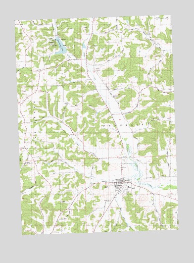
Plain, WI USGS Topographic Map
Click on map above to begin viewing in our Map Viewer.

This topographic map contains these locations and features:
Feature Name Type Latitude Longitude GNIS ID View Map
0.49 ReservoirReservoirN43.3700°W90.0318°1793573View Map
4 ReservoirReservoirN43.3083°W90.0851°1792622View Map
5 ReservoirReservoirN43.3585°W90.0704°1792403View Map
Grove SchoolSchoolN43.2978°W90.1176°1565923View Map
Hickory Grove SchoolSchoolN43.3733°W90.1207°1566357View Map
Kraemer Library and Community CenterBuildingN43.2792°W90.0433°2709606View Map
LoretaPopulated PlaceN43.3455°W90.1073°1577708View Map
Oak View SchoolSchoolN43.3567°W90.0696°1570690View Map
Oetzman G7046 DamDamN43.3700°W90.0318°1793572View Map
PlainPopulated PlaceN43.2789°W90.0437°1571574View Map
Plain Fire Department and Emergency Medical ServicesBuildingN43.2795°W90.0448°2697542View Map
Plain Honey Creek 2 3WR1225 DamDamN43.3083°W90.0851°1792621View Map
Plain Honey Creek 3 3WR175 DamDamN43.3550°W90.0851°1792404View Map
Plain Honey Creek 4 3WR175 DamDamN43.3567°W90.0718°1792402View Map
Plain Municipal ParkParkN43.2797°W90.0412°1846893View Map
Plain Police DepartmentBuildingN43.2795°W90.0447°2759944View Map
Plain Post OfficePost OfficeN43.2789°W90.0453°2709607View Map
Plain Wastewater Treatment FacilityLocaleN43.2794°W90.0397°2709605View Map
Pleasant Hill CemeteryCemeteryN43.2789°W90.0557°1846896View Map
River Valley Elementary - Plain SchoolSchoolN43.2755°W90.0505°2715646View Map
Saint Anns ShrineChurchN43.2764°W90.0582°1846914View Map
Saint Luke's Catholic SchoolSchoolN43.2762°W90.0494°2715704View Map
Saint Lukes Catholic ChurchChurchN43.2761°W90.0496°1846923View Map
Saint Lukes Catholic ChurchChurchN43.2764°W90.0496°1846924View Map
Saint Lukes CemeteryCemeteryN43.2686°W90.0540°1846925View Map
Shannahan ValleyValleyN43.3476°W90.0730°1573963View Map
Sugar Grove ValleyValleyN43.2909°W90.0411°1575025View Map
Town of FranklinCivilN43.3082°W90.0438°1583235View Map
Village of PlainCivilN43.2779°W90.0423°1583930View Map
West Spring Green SchoolSchoolN43.2517°W90.1087°1576564View Map
Westbrook Hills Golf CourseLocaleN43.2733°W90.0462°1846973View Map
White MoundSummitN43.3447°W90.0621°1846976View Map
White Mound County ParkParkN43.3605°W90.0893°1846977View Map
White Mound LakeReservoirN43.3585°W90.0889°1846978View Map
Whitemound CemeteryCemeteryN43.3286°W90.0493°1576685View Map

Note: Coordinates in the location and feature list above are referenced to NAD83 datum.


Copyright (C) 2008-2024 Ryan Niemi / Sunset Dynamics ... All Rights Reserved