TopoQuest Logo
Do you find TopoQuest useful?
Help keep TopoQuest running and adding new maps/features by donating!
Bitcoin:  19c7KJd3qBynnjoSw5npx9KScwjBe4ifkT
Litecoin:  LXs6TkuXGGXo1vDsWCkWVdjQX94eUKd6ui
Home View Maps Find Maps Find Places Resources & Links


Elkins, Arkansas Topographic Map

USGS Map Title: Elkins, AR
USGS Map MRC: 36094A1
DRG (GeoTIFF) Download: o36094a1.tif


Neighboring USGS Topographic Map Quads:


  Springdale, AR  
36094B2
 

  Sonora, AR  
36094B1
 

  Spring Valley, AR  
36093B8
 

  Fayetteville, AR  
36094A2
 

  Elkins, AR  
36094A1
 

  Goshen, AR  
36093A8
 

  West Fork, AR  
35094H2
 

  Sulphur City, AR  
35094H1
 

  Durham, AR  
35093H8


Map MRC Location:

N37°
W95°
N37°
W94°
H8 H7 H6 H5 H4 H3 H2 H1
G8 G7 G6 G5 G4 G3 G2 G1
F8 F7 F6 F5 F4 F3 F2 F1
E8 E7 E6 E5 E4 E3 E2 E1
D8 D7 D6 D5 D4 D3 D2 D1
C8 C7 C6 C5 C4 C3 C2 C1
B8 B7 B6 B5 B4 B3 B2 B1
A8 A7 A6 A5 A4 A3 A2 A1
N36°
W95°
N36°
W94°

Elkins, AR USGS 1:24K Topographic Map Preview:
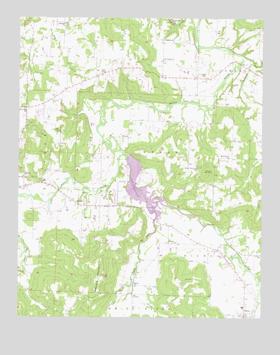
Elkins, AR USGS Topographic Map
Click on map above to begin viewing in our Map Viewer.

This topographic map contains these locations and features:
Feature Name Type Latitude Longitude GNIS ID View Map
BaldwinPopulated PlaceN36.0484°W94.0969°57317View Map
Boone CemeteryCemeteryN36.0164°W94.0393°46836View Map
Broccardo LakeReservoirN36.0867°W94.1096°80128View Map
Broccardo Lake DamDamN36.0867°W94.1085°80127View Map
Buckner ChurchChurchN36.0590°W94.1224°47150View Map
Burkhead CemeteryCemeteryN36.0126°W94.0394°47196View Map
City of ElkinsCivilN36.0163°W94.0252°2403555View Map
Crossover ParkParkN36.0931°W94.1169°65317View Map
ElkinsPopulated PlaceN36.0015°W94.0083°76869View Map
Elkins Elementary SchoolSchoolN36.0066°W94.0078°65322View Map
Elkins High SchoolSchoolN36.0044°W94.0097°65323View Map
Elkins Middle SchoolSchoolN36.0049°W94.0098°2039045View Map
Elkins Police DepartmentBuildingN36.0276°W94.0272°2118943View Map
Elkins Post OfficePost OfficeN36.0006°W94.0091°84302View Map
Elkins Volunteer Fire DepartmentBuildingN36.0005°W94.0103°2116401View Map
Fayetteville Fire Department Station 5BuildingN36.1048°W94.1210°65345View Map
Free Will ChurchChurchN36.0867°W94.1216°49233View Map
Goshen Fire Station 3BuildingN36.1024°W94.0774°2116489View Map
HabbertonPopulated PlaceN36.1151°W94.0516°77099View Map
HarrisPopulated PlaceN36.0312°W94.0477°49889View Map
Harris Post Office (historical)Post OfficeN36.0315°W94.0477°84878View Map
Henson Farm AirportAirportN36.0867°W94.1052°83697View Map
Hester CemeteryCemeteryN36.0515°W94.0905°50036View Map
KHOG-TV (Fayetteville)TowerN36.0159°W94.0833°85256View Map
Koger BranchStreamN36.0142°W94.0666°77416View Map
Lake SequoyahReservoirN36.0529°W94.0603°79754View Map
Lake Sequoyah DamDamN36.0667°W94.0652°79753View Map
Liberty School (historical)SchoolN36.0117°W94.0655°65377View Map
McGuire (historical)Populated PlaceN36.0265°W94.0083°81940View Map
McNair Middle SchoolSchoolN36.0887°W94.1180°2039051View Map
Middle Fork White RiverStreamN36.0476°W94.0594°77650View Map
Mill BranchStreamN36.1065°W94.0055°51982View Map
Missionary ChurchChurchN36.0670°W94.0171°81878View Map
Mount Vernon ChurchChurchN36.1076°W94.0516°52429View Map
Oakland ChurchChurchN36.1229°W94.1024°52962View Map
Oxford Bend CemeteryCemeteryN36.1020°W94.0296°53118View Map
Paul R Noland Wastewater Treatment PlantLocaleN36.0814°W94.0875°2416190View Map
Pierce MountainSummitN36.0756°W94.1180°65407View Map
Pleasant Ridge School (historical)SchoolN36.0884°W94.0149°65410View Map
Prathers Mill (historical)LocaleN36.0120°W94.0655°65415View Map
Richland CreekStreamN36.1079°W94.0094°54021View Map
Robinson MountainSummitN36.0190°W94.0838°58504View Map
Round MountainSummitN36.0604°W94.0280°58541View Map
Round Mountain CemeteryCemeteryN36.0665°W94.0174°54245View Map
Round Mountain SchoolSchoolN36.0629°W94.0330°54247View Map
Round Mountain Volunteer Fire DepartmentBuildingN36.0606°W94.0533°2117050View Map
Ruckers Grove (historical)Populated PlaceN36.0584°W94.1224°75281View Map
Saint Joseph CemeteryCemeteryN36.0901°W94.1085°54372View Map
Sons ChapelChurchN36.1020°W94.0827°55003View Map
Stokenbury CemeteryCemeteryN36.0144°W94.0083°55239View Map
StrainPopulated PlaceN36.0134°W94.0660°81633View Map
Strain ChurchChurchN36.0137°W94.0658°55263View Map
Strain School (historical)SchoolN36.0137°W94.0658°81634View Map
Summit (historical)Populated PlaceN36.0654°W94.0888°75282View Map
Sweetbriar ParkParkN36.1129°W94.1235°65463View Map
Sydenham (historical)Populated PlaceN36.0551°W94.0252°81635View Map
Town of GoshenCivilN36.1042°W94.0037°2406595View Map
Township of ElkinsCivilN36.0163°W94.0252°2406950View Map
Township of PrairieCivilN36.0642°W94.0973°69797View Map
Township of WymanCivilN36.0698°W94.0439°69812View Map
Vandergriff Elementary SchoolSchoolN36.0911°W94.1166°2039050View Map
West Fork White RiverStreamN36.0687°W94.0716°74069View Map
WymanPopulated PlaceN36.0751°W94.0694°57240View Map
Wyman School (historical)SchoolN36.0751°W94.0688°65501View Map

Note: Coordinates in the location and feature list above are referenced to NAD83 datum.


Copyright (C) 2008-2024 Ryan Niemi / Sunset Dynamics ... All Rights Reserved