TopoQuest Logo
Do you find TopoQuest useful?
Help keep TopoQuest running and adding new maps/features by donating!
Bitcoin:  19c7KJd3qBynnjoSw5npx9KScwjBe4ifkT
Litecoin:  LXs6TkuXGGXo1vDsWCkWVdjQX94eUKd6ui
Home View Maps Find Maps Find Places Resources & Links


West Fork, Arkansas Topographic Map

USGS Map Title: West Fork, AR
USGS Map MRC: 35094H2
DRG (GeoTIFF) Download: o35094h2.tif


Neighboring USGS Topographic Map Quads:


  Wheeler, AR  
36094A3
 

  Fayetteville, AR  
36094A2
 

  Elkins, AR  
36094A1
 

  Prairie Grove, AR  
35094H3
 

  West Fork, AR  
35094H2
 

  Sulphur City, AR  
35094H1
 

  Strickler, AR  
35094G3
 

  Winslow, AR  
35094G2
 

  Brentwood, AR  
35094G1


Map MRC Location:

N36°
W95°
N36°
W94°
H8 H7 H6 H5 H4 H3 H2 H1
G8 G7 G6 G5 G4 G3 G2 G1
F8 F7 F6 F5 F4 F3 F2 F1
E8 E7 E6 E5 E4 E3 E2 E1
D8 D7 D6 D5 D4 D3 D2 D1
C8 C7 C6 C5 C4 C3 C2 C1
B8 B7 B6 B5 B4 B3 B2 B1
A8 A7 A6 A5 A4 A3 A2 A1
N35°
W95°
N35°
W94°

West Fork, AR USGS 1:24K Topographic Map Preview:
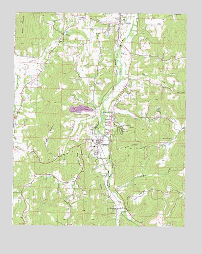
West Fork, AR USGS Topographic Map
Click on map above to begin viewing in our Map Viewer.

This topographic map contains these locations and features:
Feature Name Type Latitude Longitude GNIS ID View Map
Arkansas School for Information and TechnologySchoolN35.9956°W94.1733°2092978View Map
Baptist Ford CemeteryCemeteryN35.9800°W94.1731°55784View Map
Bloyd MountainSummitN35.9234°W94.1616°81370View Map
Boone CemeteryCemeteryN35.9880°W94.1916°46835View Map
Campbell Church CemeteryCemeteryN35.9584°W94.1905°47347View Map
City of GreenlandCivilN35.9987°W94.1875°2403742View Map
City of West ForkCivilN35.9357°W94.1801°2405707View Map
Dye CreekStreamN35.9442°W94.1860°48725View Map
Everett MountainSummitN35.8901°W94.1355°65330View Map
Fairview School (historical)SchoolN35.9898°W94.2127°65332View Map
First Baptist Church of GreenlandChurchN35.9940°W94.1777°65347View Map
Flat Rock School (historical)SchoolN35.9851°W94.1513°65355View Map
Fraker MountainSummitN35.9298°W94.2244°49216View Map
Friendship ChurchChurchN35.9042°W94.2222°49268View Map
GreenlandPopulated PlaceN35.9942°W94.1752°77072View Map
Greenland Elementary SchoolSchoolN35.9965°W94.1714°65363View Map
Greenland High SchoolSchoolN35.9943°W94.1727°65364View Map
Greenland Middle SchoolSchoolN35.9956°W94.1733°2039061View Map
Greenland Police DepartmentBuildingN35.9969°W94.1734°2118942View Map
Hogeye Volunteer Fire Department Station 2BuildingN35.9771°W94.2230°2116582View Map
Lake WilsonLakeN35.9984°W94.1351°75230View Map
Lake Wilson ParkParkN35.9995°W94.1366°65376View Map
Mill CreekStreamN35.8940°W94.1752°52025View Map
Mineral Springs CemeteryCemeteryN35.9267°W94.1346°52090View Map
Mount Gap ChurchChurchN35.9681°W94.2285°77711View Map
Old Male Coal BankMineN35.9229°W94.1299°65402View Map
Owl HollowValleyN35.9545°W94.1321°53114View Map
Pitkin CornerPopulated PlaceN35.8854°W94.1749°78023View Map
Pitkin School (historical)SchoolN35.8848°W94.1755°65408View Map
RidgeLocaleN35.9237°W94.1399°54034View Map
Rock CreekStreamN35.9623°W94.1724°78195View Map
Round MountainSummitN35.9501°W94.1477°65430View Map
Sugar MountainSummitN35.8937°W94.1588°58706View Map
Township of GreenlandCivilN35.9858°W94.1763°69789View Map
Township of West ForkCivilN35.9244°W94.1687°69809View Map
Union Star CemeteryCemeteryN35.8923°W94.2033°55832View Map
Wasburn MountainSummitN35.9565°W94.2135°65476View Map
Washington CountyCivilN35.9791°W94.2156°69905View Map
West ForkPopulated PlaceN35.9242°W94.1885°81903View Map
West Fork CemeteryCemeteryN35.9326°W94.1935°56179View Map
West Fork Elementary SchoolSchoolN35.9252°W94.1932°65488View Map
West Fork Elementary SchoolSchoolN35.9252°W94.1931°65490View Map
West Fork High SchoolSchoolN35.9218°W94.1919°65489View Map
West Fork Police DepartmentBuildingN35.9244°W94.1892°2118939View Map
West Fork Volunteer Fire Department Station 1BuildingN35.9235°W94.1904°2117292View Map
West Fork Volunteer Fire Department Station 3BuildingN35.9969°W94.1733°2117293View Map
West MountainSummitN35.9148°W94.2038°58855View Map
White Oak MountainSummitN35.9773°W94.1405°65493View Map
Winn CreekStreamN35.8834°W94.1688°78788View Map
WoolseyPopulated PlaceN35.8854°W94.1685°78809View Map
Woolsey CemeteryCemeteryN35.8837°W94.1671°56540View Map
Woolsey ChurchChurchN35.8823°W94.1755°56541View Map
Woolsey Post Office (historical)Post OfficeN35.8854°W94.1755°84326View Map

Note: Coordinates in the location and feature list above are referenced to NAD83 datum.


Copyright (C) 2008-2024 Ryan Niemi / Sunset Dynamics ... All Rights Reserved