TopoQuest Logo
Do you find TopoQuest useful?
Help keep TopoQuest running and adding new maps/features by donating!
Bitcoin:  19c7KJd3qBynnjoSw5npx9KScwjBe4ifkT
Litecoin:  LXs6TkuXGGXo1vDsWCkWVdjQX94eUKd6ui
Home View Maps Find Maps Find Places Resources & Links


Goshen, Arkansas Topographic Map

USGS Map Title: Goshen, AR
USGS Map MRC: 36093A8
DRG (GeoTIFF) Download: o36093a8.tif


Neighboring USGS Topographic Map Quads:


  Sonora, AR  
36094B1
 

  Spring Valley, AR  
36093B8
 

  Hindsville, AR  
36093B7
 

  Elkins, AR  
36094A1
 

  Goshen, AR  
36093A8
 

  Hartwell, AR  
36093A7
 

  Sulphur City, AR  
35094H1
 

  Durham, AR  
35093H8
 

  Japton, AR  
35093H7


Map MRC Location:

N37°
W94°
N37°
W93°
H8 H7 H6 H5 H4 H3 H2 H1
G8 G7 G6 G5 G4 G3 G2 G1
F8 F7 F6 F5 F4 F3 F2 F1
E8 E7 E6 E5 E4 E3 E2 E1
D8 D7 D6 D5 D4 D3 D2 D1
C8 C7 C6 C5 C4 C3 C2 C1
B8 B7 B6 B5 B4 B3 B2 B1
A8 A7 A6 A5 A4 A3 A2 A1
N36°
W94°
N36°
W93°

Goshen, AR USGS 1:24K Topographic Map Preview:
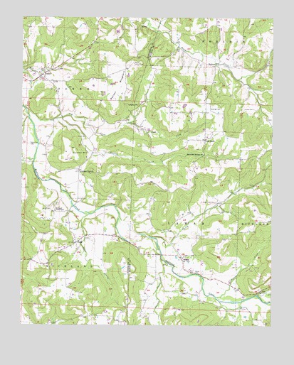
Goshen, AR USGS Topographic Map
Click on map above to begin viewing in our Map Viewer.

This topographic map contains these locations and features:
Feature Name Type Latitude Longitude GNIS ID View Map
Bell CemeteryCemeteryN36.1128°W93.9227°46349View Map
Benson Lookout TowerTowerN36.1065°W93.9446°81970View Map
Benson MountainSummitN36.0992°W93.9541°57359View Map
Boatrigth CemeteryCemeteryN36.0881°W93.9063°46786View Map
BuckeyePopulated PlaceN36.1065°W93.9021°56943View Map
Cave CreekStreamN36.0820°W93.9463°47538View Map
Cherry CreekStreamN36.0354°W93.9333°47725View Map
Cherry Creek CemeteryCemeteryN36.0503°W93.9038°47726View Map
Cross RoadsPopulated PlaceN36.0754°W93.9085°56978View Map
Culwell CemeteryCemeteryN36.0767°W93.9685°48255View Map
Drakes CreekStreamN36.0129°W93.8816°71417View Map
Dry CreekStreamN36.0876°W93.9983°48642View Map
Gilliam MountainSummitN36.0926°W93.9919°65361View Map
GoshenPopulated PlaceN36.1012°W93.9913°57835View Map
Goshen City Marshall's OfficeBuildingN36.1008°W93.9887°2118995View Map
Goshen Fire Station 1BuildingN36.1008°W93.9888°2116488View Map
Goshen Post OfficePost OfficeN36.1010°W93.9924°84874View Map
Johnson CemeteryCemeteryN36.0878°W93.8846°50683View Map
Langley ChurchChurchN36.0892°W93.9427°50987View Map
Lollars CreekStreamN36.0123°W93.8821°72449View Map
Mount OlivePopulated PlaceN36.0017°W93.9513°65389View Map
Mountain Springs ChurchChurchN36.0695°W93.9096°52496View Map
Pigeon CreekStreamN36.0117°W93.9027°53360View Map
Richland TabernacleChurchN36.0465°W93.9833°54022View Map
Richland View ChurchChurchN36.0626°W93.9716°81891View Map
Sinking CreekStreamN36.0837°W93.9833°78370View Map
Smith CemeteryCemeteryN36.0470°W93.9857°54938View Map
Thorney BranchStreamN36.0256°W93.9283°55553View Map
Tisdale FordCrossingN36.0737°W93.9921°58749View Map
Township of GoshenCivilN36.0994°W93.9892°69788View Map
Township of RichlandCivilN36.0222°W93.9952°69802View Map
Trammel MountainSummitN36.0720°W93.9755°55635View Map
TuttlePopulated PlaceN36.0337°W93.9724°57216View Map
Tuttle BranchStreamN36.0451°W93.9671°55750View Map
WesleyPopulated PlaceN36.0273°W93.9202°81902View Map
Wesley CemeteryCemeteryN36.0215°W93.9144°56152View Map
Wesley Post OfficePost OfficeN36.0273°W93.9206°84385View Map
Wesley Volunteer Fire DepartmentBuildingN36.0274°W93.9196°2117290View Map

Note: Coordinates in the location and feature list above are referenced to NAD83 datum.


Copyright (C) 2008-2024 Ryan Niemi / Sunset Dynamics ... All Rights Reserved