TopoQuest Logo
Do you find TopoQuest useful?
Help keep TopoQuest running and adding new maps/features by donating!
Bitcoin:  19c7KJd3qBynnjoSw5npx9KScwjBe4ifkT
Litecoin:  LXs6TkuXGGXo1vDsWCkWVdjQX94eUKd6ui
Home View Maps Find Maps Find Places Resources & Links


Ellendale, Delaware Topographic Map

USGS Map Title: Ellendale, DE
USGS Map MRC: 38075G4
DRG (GeoTIFF) Download: o38075g4.tif


Neighboring USGS Topographic Map Quads:


  Harrington, DE  
38075H5
 

  Milford, DE  
38075H4
 

  Mispillion River, DE  
38075H3
 

  Greenwood, DE  
38075G5
 

  Ellendale, DE  
38075G4
 

  Milton, DE  
38075G3
 

  Seaford East, DE  
38075F5
 

  Georgetown, DE  
38075F4
 

  Harbeson, DE  
38075F3


Map MRC Location:

N39°
W76°
N39°
W75°
H8 H7 H6 H5 H4 H3 H2 H1
G8 G7 G6 G5 G4 G3 G2 G1
F8 F7 F6 F5 F4 F3 F2 F1
E8 E7 E6 E5 E4 E3 E2 E1
D8 D7 D6 D5 D4 D3 D2 D1
C8 C7 C6 C5 C4 C3 C2 C1
B8 B7 B6 B5 B4 B3 B2 B1
A8 A7 A6 A5 A4 A3 A2 A1
N38°
W76°
N38°
W75°

Ellendale, DE USGS 1:24K Topographic Map Preview:
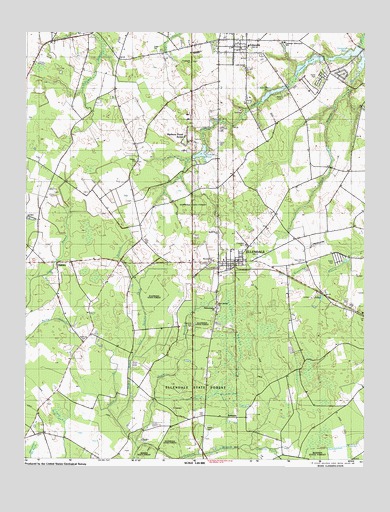
Ellendale, DE USGS Topographic Map
Click on map above to begin viewing in our Map Viewer.

This topographic map contains these locations and features:
Feature Name Type Latitude Longitude GNIS ID View Map
Banning CemeteryCemeteryN38.7839°W75.4788°213597View Map
Christian TabernacleChurchN38.8707°W75.4310°215043View Map
Christian Tabernacle AcademySchoolN38.8702°W75.4094°214988View Map
Church BranchStreamN38.8676°W75.3766°213801View Map
Church TabernacleChurchN38.8707°W75.4316°215042View Map
Clendaniel PondReservoirN38.8556°W75.4094°213808View Map
Clendaniel Pond DamDamN38.8573°W75.4041°216751View Map
Cubbage PondReservoirN38.8644°W75.3959°213744View Map
Cubbage Pond DamDamN38.8654°W75.3902°216744View Map
EllendalePopulated PlaceN38.8071°W75.4227°213934View Map
Ellendale CemeteryCemeteryN38.8115°W75.4185°217406View Map
Ellendale Police DepartmentBuildingN38.8060°W75.4247°2131111View Map
Ellendale Post OfficePost OfficeN38.8074°W75.4258°2378947View Map
Ellendale State ForestForestN38.7704°W75.4358°213935View Map
Ellendale SwampSwampN38.7857°W75.4241°213936View Map
Ellendale Town HallBuildingN38.8082°W75.4248°2378946View Map
Ellendale Volunteer Fire CompanyBuildingN38.8073°W75.4219°2610774View Map
Faith CemeteryCemeteryN38.7623°W75.4342°217282View Map
Faith Church (historical)ChurchN38.7621°W75.4338°217398View Map
FederalsburgPopulated PlaceN38.8282°W75.4294°216748View Map
Gravelly DitchStreamN38.7534°W75.4205°214018View Map
GreentopPopulated PlaceN38.8534°W75.4185°216749View Map
Hilltop AcresPopulated PlaceN38.8484°W75.4294°215556View Map
Holly HillPopulated PlaceN38.8401°W75.4294°215554View Map
Hudson PondReservoirN38.8468°W75.4352°216747View Map
Hudson Pond AcresPopulated PlaceN38.8418°W75.4399°216746View Map
Kent - Sussex Detoxification CenterBuildingN38.8074°W75.4272°2619891View Map
LincolnPopulated PlaceN38.8698°W75.4230°214221View Map
Lincoln Post OfficePost OfficeN38.8706°W75.4234°2378948View Map
Lincoln United Methodist ChurchChurchN38.8687°W75.4219°215029View Map
Lincoln VillagePopulated PlaceN38.8673°W75.4391°215638View Map
Little Union Baptist ChurchChurchN38.8632°W75.4191°217279View Map
Maple BranchStreamN38.7554°W75.4594°214268View Map
Maple Marsh and Beaver Dam BranchStreamN38.7615°W75.4660°214269View Map
Metropolitan United Methodist ChurchChurchN38.8684°W75.4302°215030View Map
Mount Zion African Methodist Episcopal ChurchChurchN38.8071°W75.4319°215099View Map
New MarketPopulated PlaceN38.8073°W75.3969°216750View Map
New Market CemeteryCemeteryN38.8065°W75.3980°214384View Map
New Market Village Mobile Home ParkPopulated PlaceN38.8098°W75.3871°216640View Map
New Shiloh F B H Church of GodChurchN38.7948°W75.4294°217278View Map
OakleyPopulated PlaceN38.8065°W75.4888°216166View Map
Oakley ChurchChurchN38.8065°W75.4891°217277View Map
Philadelphia Pentecostal Holiness ChurchChurchN38.7937°W75.4302°217281View Map
Pondside AcresPopulated PlaceN38.8568°W75.4035°215557View Map
Prong Number OneStreamN38.7526°W75.4585°214499View Map
RobbinsPopulated PlaceN38.7621°W75.4216°216195View Map
Solid Rock ChurchChurchN38.8157°W75.4288°217280View Map
Sussex WoodsPopulated PlaceN38.8362°W75.4388°215553View Map
Swiggetts PondReservoirN38.8671°W75.3812°214714View Map
Swiggetts Pond DamDamN38.8690°W75.3774°216745View Map
Tessie-Maringola EstatesPopulated PlaceN38.8351°W75.4363°215552View Map
The United Methodist ChurchChurchN38.8071°W75.4252°215098View Map
Town of EllendaleCivilN38.8102°W75.4249°2390169View Map
Union ChurchChurchN38.8357°W75.4594°214782View Map
Walkers AcresPopulated PlaceN38.8048°W75.4313°215540View Map

Note: Coordinates in the location and feature list above are referenced to NAD83 datum.


Copyright (C) 2008-2024 Ryan Niemi / Sunset Dynamics ... All Rights Reserved