TopoQuest Logo
Do you find TopoQuest useful?
Help keep TopoQuest running and adding new maps/features by donating!
Bitcoin:  19c7KJd3qBynnjoSw5npx9KScwjBe4ifkT
Litecoin:  LXs6TkuXGGXo1vDsWCkWVdjQX94eUKd6ui
Home View Maps Find Maps Find Places Resources & Links


Mispillion River, Delaware Topographic Map

USGS Map Title: Mispillion River, DE
USGS Map MRC: 38075H3
DRG (GeoTIFF) Download: o38075h3.tif


Neighboring USGS Topographic Map Quads:


  Frederica, DE  
39075A4
 

  Bennetts Pier, DE  
39075A3


  Milford, DE  
38075H4
 

  Mispillion River, DE  
38075H3


  Ellendale, DE  
38075G4
 

  Milton, DE  
38075G3
 

  Lewes, DE  
38075G2


Map MRC Location:

N39°
W76°
N39°
W75°
H8 H7 H6 H5 H4 H3 H2 H1
G8 G7 G6 G5 G4 G3 G2 G1
F8 F7 F6 F5 F4 F3 F2 F1
E8 E7 E6 E5 E4 E3 E2 E1
D8 D7 D6 D5 D4 D3 D2 D1
C8 C7 C6 C5 C4 C3 C2 C1
B8 B7 B6 B5 B4 B3 B2 B1
A8 A7 A6 A5 A4 A3 A2 A1
N38°
W76°
N38°
W75°

Mispillion River, DE USGS 1:24K Topographic Map Preview:
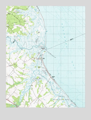
Mispillion River, DE USGS Topographic Map
Click on map above to begin viewing in our Map Viewer.

This topographic map contains these locations and features:
Feature Name Type Latitude Longitude GNIS ID View Map
Battery Hall (historical)MilitaryN38.9350°W75.3306°2127917View Map
Battery Haslet (historical)MilitaryN38.9331°W75.3317°2127916View Map
Beaverdam BranchStreamN38.9087°W75.3360°213620View Map
Big Stone BeachBeachN38.9943°W75.3219°213665View Map
Cains LandingLocaleN38.9579°W75.3599°217864View Map
Cedar BeachLocaleN38.9329°W75.3169°213770View Map
Cedar Beach BridgeBridgeN38.9348°W75.3238°217181View Map
Cedar CreekStreamN38.9479°W75.3132°213773View Map
Cedar Creek Boat Launching AreaLocaleN38.9412°W75.3213°215634View Map
Cedar Creek CanalCanalN38.9348°W75.3238°216905View Map
Cedar NeckCapeN38.9196°W75.3627°213778View Map
Cedar Neck CemeteryCemeteryN38.9266°W75.3685°2378962View Map
Cedar Neck SchoolSchoolN38.9284°W75.3616°213779View Map
Cedar Neck United Methodist ChurchChurchN38.9265°W75.3685°216326View Map
Conch BarBarN38.9679°W75.3102°213821View Map
Crooked GutGutN38.9659°W75.3371°213845View Map
Davis LandingLocaleN38.9007°W75.3360°217865View Map
Draper-Bennet DitchCanalN38.8771°W75.2988°213545View Map
Drapers Inlet (historical)GutN38.8987°W75.2935°215276View Map
Fort Saulsbury (historical)MilitaryN38.9340°W75.3316°217866View Map
Fowler BeachBeachN38.8807°W75.2680°213977View Map
Grecos CanalCanalN38.9793°W75.3171°216906View Map
Maloneys LandingLocaleN38.9612°W75.3710°217868View Map
Memorial Volunteer Fire CompanyBuildingN38.9136°W75.3051°2610835View Map
Milford Neck Wildlife AreaParkN38.9668°W75.3705°216882View Map
Milford Neck Wildlife Area - Cedar Creek UnitParkN38.9112°W75.3291°215675View Map
Milford South DivisionCivilN38.8758°W75.2966°1935617View Map
Mispillion LightPopulated PlaceN38.9473°W75.3149°214329View Map
Mispillion RiverStreamN38.9515°W75.3132°214330View Map
Murphy's LandingAirportN38.9131°W75.3501°2770571View Map
Rawley IslandIslandN38.9682°W75.3235°214518View Map
Revills LandingLocaleN38.9468°W75.3510°217872View Map
Scotts CornersLocaleN38.9912°W75.3710°214625View Map
Sheppards IslandIslandN38.9243°W75.3224°214638View Map
Slaughter BeachBeachN38.9126°W75.3052°217182View Map
Slaughter BeachPopulated PlaceN38.9129°W75.3041°214663View Map
Slaughter CreekStreamN38.9212°W75.3266°214664View Map
Slaughter NeckCapeN38.8762°W75.3338°214665View Map
Todds IslandIslandN38.9112°W75.3252°214749View Map
Town of Slaughter BeachCivilN38.9142°W75.3084°2391412View Map

Note: Coordinates in the location and feature list above are referenced to NAD83 datum.


Copyright (C) 2008-2024 Ryan Niemi / Sunset Dynamics ... All Rights Reserved