TopoQuest Logo
Do you find TopoQuest useful?
Help keep TopoQuest running and adding new maps/features by donating!
Bitcoin:  19c7KJd3qBynnjoSw5npx9KScwjBe4ifkT
Litecoin:  LXs6TkuXGGXo1vDsWCkWVdjQX94eUKd6ui
Home View Maps Find Maps Find Places Resources & Links


Harbeson, Delaware Topographic Map

USGS Map Title: Harbeson, DE
USGS Map MRC: 38075F3
DRG (GeoTIFF) Download: o38075f3.tif


Neighboring USGS Topographic Map Quads:


  Ellendale, DE  
38075G4
 

  Milton, DE  
38075G3
 

  Lewes, DE  
38075G2
 

  Georgetown, DE  
38075F4
 

  Harbeson, DE  
38075F3
 

  Fairmount, DE  
38075F2
 

  Trap Pond, DE  
38075E4
 

  Millsboro, DE  
38075E3
 

  Frankford, DE  
38075E2


Map MRC Location:

N39°
W76°
N39°
W75°
H8 H7 H6 H5 H4 H3 H2 H1
G8 G7 G6 G5 G4 G3 G2 G1
F8 F7 F6 F5 F4 F3 F2 F1
E8 E7 E6 E5 E4 E3 E2 E1
D8 D7 D6 D5 D4 D3 D2 D1
C8 C7 C6 C5 C4 C3 C2 C1
B8 B7 B6 B5 B4 B3 B2 B1
A8 A7 A6 A5 A4 A3 A2 A1
N38°
W76°
N38°
W75°

Harbeson, DE USGS 1:24K Topographic Map Preview:
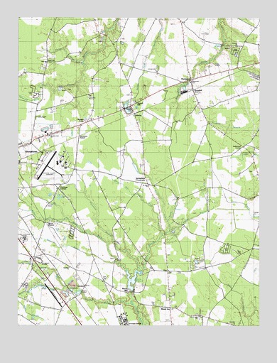
Harbeson, DE USGS Topographic Map
Click on map above to begin viewing in our Map Viewer.

This topographic map contains these locations and features:
Feature Name Type Latitude Longitude GNIS ID View Map
All Faith ChapelChurchN38.6276°W75.3227°217356View Map
Alms House DitchStreamN38.6401°W75.3507°213557View Map
Andersons CornerPopulated PlaceN38.6987°W75.2594°216787View Map
Apostolic Faith ChurchChurchN38.6259°W75.2627°217353View Map
Apostolics of GeorgetownChurchN38.6487°W75.3485°217354View Map
Avalon Park Mobile Home ParkPopulated PlaceN38.6579°W75.2663°216615View Map
Beaverdam CemeteryCemeteryN38.7243°W75.2860°213625View Map
BennumPopulated PlaceN38.7112°W75.3141°216030View Map
Bethesda ChurchChurchN38.6384°W75.3469°213648View Map
Black Savannah DitchStreamN38.7223°W75.3646°213670View Map
Bowdens Garage (historical)Populated PlaceN38.6982°W75.3749°217424View Map
Briarwood ManorPopulated PlaceN38.7207°W75.3005°215530View Map
Broadkill StationLocaleN38.7207°W75.2844°213717View Map
Cabbage CornerLocaleN38.6807°W75.3544°215409View Map
Catfish BridgeBridgeN38.6521°W75.3238°216785View Map
Cheer Community CenterBuildingN38.7007°W75.3686°2378961View Map
Christiana Care LifeNet Air Medical TransportBuildingN38.6922°W75.3619°2642768View Map
Cool Spring FarmsPopulated PlaceN38.7259°W75.2524°216786View Map
Cool Spring ManorPopulated PlaceN38.7198°W75.2560°215532View Map
Deep BranchStreamN38.6468°W75.3127°213862View Map
DeerwoodPopulated PlaceN38.7207°W75.3002°215531View Map
Delaware Coastal AirportAirportN38.6905°W75.3634°217228View Map
Delmarva RacewayLocaleN38.7046°W75.3607°217762View Map
Dogwood Park Mobile Home ParkPopulated PlaceN38.6384°W75.3146°216611View Map
Dutton DitchStreamN38.7323°W75.3407°213918View Map
Edward Cordrey SubdivisionPopulated PlaceN38.6290°W75.2810°215402View Map
Eli Walls DitchStreamN38.6476°W75.3182°213933View Map
Fish Hook Mobile Home CourtPopulated PlaceN38.6432°W75.3299°216612View Map
Gills BranchStreamN38.6507°W75.3238°213998View Map
Gran-villePopulated PlaceN38.6371°W75.2966°215403View Map
Gravel HillPopulated PlaceN38.7143°W75.3157°216102View Map
Greenlea AcresPopulated PlaceN38.6979°W75.3746°215417View Map
HarbesonPopulated PlaceN38.7248°W75.2849°214054View Map
Harbeson Post OfficePost OfficeN38.7246°W75.2849°2378972View Map
Holly Leaf Estates Mobile Home ParkPopulated PlaceN38.6540°W75.2596°216613View Map
Horse Pound Swamp DitchStreamN38.6409°W75.3510°217390View Map
Hunters MillpondReservoirN38.7388°W75.2697°214132View Map
Josephs Airport (historical)AirportN38.6376°W75.3552°217229View Map
Kawan AcresPopulated PlaceN38.6596°W75.2985°215405View Map
Kingdom Hall of Jehovahs WitnessesChurchN38.7023°W75.3594°217352View Map
Larence Cordrey SubdivisionPopulated PlaceN38.6251°W75.2605°215400View Map
Lazy LakePopulated PlaceN38.7340°W75.2613°215534View Map
McGee DitchStreamN38.6684°W75.3507°214291View Map
Milton DivisionCivilN38.7452°W75.2798°1935619View Map
Morris MillPopulated PlaceN38.6390°W75.3169°216160View Map
Morris MillpondReservoirN38.6434°W75.3160°214340View Map
Morris Millpond DamDamN38.6393°W75.3160°216788View Map
Mount JoyPopulated PlaceN38.6321°W75.2960°216789View Map
New Saint Johns CemeteryCemeteryN38.6284°W75.2809°2378974View Map
New Saint Johns ChurchChurchN38.6290°W75.2813°215401View Map
Patterson Place Mobile Home ParkPopulated PlaceN38.6534°W75.2596°216614View Map
Peterkins BranchStreamN38.6473°W75.3107°214443View Map
Pine Lake DevelopmentPopulated PlaceN38.6654°W75.2885°215406View Map
Piney Grove ManorPopulated PlaceN38.6432°W75.3705°216784View Map
Rogers DevelopmentPopulated PlaceN38.7009°W75.3641°215528View Map
Saint Johns ChurchChurchN38.6821°W75.3074°215408View Map
Saint Johns United Methodist ChurchChurchN38.6821°W75.3069°214580View Map
Saint Peters Friends ChurchChurchN38.7384°W75.2624°217350View Map
Sand HillPopulated PlaceN38.7321°W75.3602°216202View Map
Sand Hill ChurchChurchN38.7321°W75.3602°215529View Map
Saulsbury SwitchPopulated PlaceN38.7018°W75.3432°216206View Map
Savannah DitchStreamN38.7184°W75.3746°213547View Map
Shady Rest ParkPopulated PlaceN38.7184°W75.2613°215533View Map
Shingle PointLocaleN38.7079°W75.3391°214641View Map
Simpler BranchStreamN38.6621°W75.2996°214657View Map
Sockorockets DitchStreamN38.6676°W75.2971°214673View Map
Springfield CrossroadsPopulated PlaceN38.6826°W75.3077°216224View Map
Springfield Farms AdditionPopulated PlaceN38.6804°W75.3746°215416View Map
StockleyPopulated PlaceN38.6409°W75.3399°216228View Map
Stockley BranchStreamN38.6332°W75.3144°214695View Map
Stockley CenterHospitalN38.6271°W75.3196°217425View Map
Sussex Central Senior High SchoolSchoolN38.6346°W75.3249°214943View Map
Sussex Community Corrections CenterBuildingN38.6596°W75.3710°2378960View Map
Sussex Correctional InstitutionBuildingN38.6600°W75.3713°217349View Map
Sussex CountyCivilN38.6833°W75.3395°217269View Map
Sussex County Industrial ParkLocaleN38.6925°W75.3506°2378964View Map
The Apostolic ChurchChurchN38.7268°W75.2502°217351View Map
Triumph of the Church and Kingdom of God in ChristChurchN38.6484°W75.2577°217355View Map
Welsh BranchStreamN38.6640°W75.2960°214817View Map
White Horse FarmPopulated PlaceN38.6918°W75.2530°215407View Map
White Oak Swamp DitchStreamN38.6621°W75.2996°214844View Map
Wood BranchPopulated PlaceN38.6671°W75.3607°216255View Map
ZoarPopulated PlaceN38.6471°W75.2971°216261View Map
Zoar ChurchChurchN38.6462°W75.2971°215404View Map

Note: Coordinates in the location and feature list above are referenced to NAD83 datum.


Copyright (C) 2008-2025 Ryan Niemi / Sunset Dynamics ... All Rights Reserved