TopoQuest Logo
Do you find TopoQuest useful?
Help keep TopoQuest running and adding new maps/features by donating!
Bitcoin:  19c7KJd3qBynnjoSw5npx9KScwjBe4ifkT
Litecoin:  LXs6TkuXGGXo1vDsWCkWVdjQX94eUKd6ui
Home View Maps Find Maps Find Places Resources & Links


Ellisburg, New York Topographic Map

USGS Map Title: Ellisburg, NY
USGS Map MRC: 43076F2
DRG (GeoTIFF) Download: o43076f2.tif


Neighboring USGS Topographic Map Quads:


  Stony Point, NY  
43076G3
 

  Henderson, NY  
43076G2
 

  Adams, NY  
43076G1


  Ellisburg, NY  
43076F2
 

  Sandy Creek, NY  
43076F1
 

  Texas, NY  
43076E3
 

  Pulaski, NY  
43076E2
 

  Richland, NY  
43076E1


Map MRC Location:

N44°
W77°
N44°
W76°
H8 H7 H6 H5 H4 H3 H2 H1
G8 G7 G6 G5 G4 G3 G2 G1
F8 F7 F6 F5 F4 F3 F2 F1
E8 E7 E6 E5 E4 E3 E2 E1
D8 D7 D6 D5 D4 D3 D2 D1
C8 C7 C6 C5 C4 C3 C2 C1
B8 B7 B6 B5 B4 B3 B2 B1
A8 A7 A6 A5 A4 A3 A2 A1
N43°
W77°
N43°
W76°

Ellisburg, NY USGS 1:24K Topographic Map Preview:
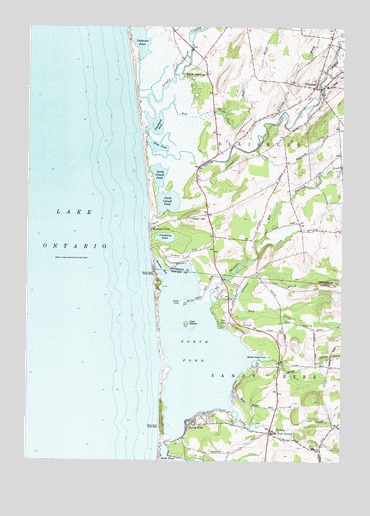
Ellisburg, NY USGS Topographic Map
Click on map above to begin viewing in our Map Viewer.

This topographic map contains these locations and features:
Feature Name Type Latitude Longitude GNIS ID View Map
Bartlett MarinaLocaleN43.6317°W76.1869°973667View Map
Bear CreekStreamN43.7306°W76.1333°943257View Map
Big Deerlick CreekStreamN43.6851°W76.1580°943873View Map
Blind CreekStreamN43.6545°W76.1533°944253View Map
Blind Creek CoveBayN43.6545°W76.1560°944254View Map
Brennan's Bay CampgroundLocaleN43.6819°W76.1853°2615188View Map
Brennan's Bay MarinaHarborN43.6819°W76.1853°2615014View Map
Carl IslandIslandN43.6645°W76.1869°945832View Map
Colwell HillSummitN43.6948°W76.1855°947212View Map
Cranberry PondLakeN43.6894°W76.1954°947674View Map
Doubledale FarmLocaleN43.7489°W76.1311°2702785View Map
Eastman FarmsLocaleN43.7367°W76.1631°2702783View Map
EllisburgPopulated PlaceN43.7328°W76.1360°975770View Map
Ellisburg Free LibraryBuildingN43.7347°W76.1309°2617266View Map
Ellisburg Volunteer Fire DepartmentBuildingN43.7329°W76.1351°2734981View Map
Elms Golf ClubLocaleN43.6684°W76.1712°2715206View Map
Floodwood PondLakeN43.7223°W76.1991°950294View Map
Freemans MarinaLocaleN43.6767°W76.1724°973672View Map
Goodenough Church (historical)ChurchN43.6781°W76.1575°2105955View Map
Goose PondLakeN43.7155°W76.1979°951371View Map
Greene PointCapeN43.6709°W76.1874°973613View Map
Greene Point MarinaLocaleN43.6726°W76.1805°973671View Map
Kibling BrookStreamN43.7159°W76.1680°970265View Map
Lakeview PondLakeN43.7489°W76.2066°973616View Map
Lindsey CreekStreamN43.6698°W76.1769°970290View Map
Little Deerlick CreekStreamN43.7148°W76.1599°955511View Map
Little Sandy CreekStreamN43.6398°W76.1691°955681View Map
Montario PointPopulated PlaceN43.6917°W76.2010°957539View Map
Mud BrookStreamN43.7251°W76.1971°957987View Map
Mud CreekStreamN43.6723°W76.1685°958010View Map
North Colwell PondLakeN43.7073°W76.1981°958756View Map
North LandingPopulated PlaceN43.7356°W76.1844°972867View Map
North PondLakeN43.6561°W76.1821°958886View Map
Reiters MarinaLocaleN43.6742°W76.1702°973673View Map
Renshaw BayBayN43.6800°W76.1972°962383View Map
Sandy CreekStreamN43.7198°W76.2055°970581View Map
Sandy PondPopulated PlaceN43.6359°W76.1841°964440View Map
Sandy Pond CornersLocaleN43.6331°W76.1530°964441View Map
School Number 11 (historical)SchoolN43.6778°W76.1572°2106200View Map
School Number 12 (historical)SchoolN43.6272°W76.1686°2106201View Map
School Number 13 (historical)SchoolN43.6283°W76.1333°2106202View Map
School Number 20 (historical)SchoolN43.7467°W76.1294°2105956View Map
School Number 8 (historical)SchoolN43.6586°W76.1264°2106199View Map
Seber Shore MarinaLocaleN43.6417°W76.1669°973674View Map
Skinner CreekStreamN43.6701°W76.1769°942106View Map
South Colwell PondLakeN43.6995°W76.1944°965725View Map
South Sandy CreekStreamN43.7201°W76.2027°965862View Map
South Sandy Creek BridgeBridgeN43.7325°W76.1339°2614992View Map
The ElmsPopulated PlaceN43.6640°W76.1724°967234View Map
Village of EllisburgCivilN43.7351°W76.1344°2391663View Map

Note: Coordinates in the location and feature list above are referenced to NAD83 datum.


Copyright (C) 2008-2024 Ryan Niemi / Sunset Dynamics ... All Rights Reserved