TopoQuest Logo
Do you find TopoQuest useful?
Help keep TopoQuest running and adding new maps/features by donating!
Bitcoin:  19c7KJd3qBynnjoSw5npx9KScwjBe4ifkT
Litecoin:  LXs6TkuXGGXo1vDsWCkWVdjQX94eUKd6ui
Home View Maps Find Maps Find Places Resources & Links


Richland, New York Topographic Map

USGS Map Title: Richland, NY
USGS Map MRC: 43076E1
DRG (GeoTIFF) Download: o43076e1.tif


Neighboring USGS Topographic Map Quads:


  Ellisburg, NY  
43076F2
 

  Sandy Creek, NY  
43076F1
 

  Boylston Center, NY  
43075F8
 

  Pulaski, NY  
43076E2
 

  Richland, NY  
43076E1
 

  Orwell, NY  
43075E8
 

  Mexico, NY  
43076D2
 

  Dugway, NY  
43076D1
 

  Williamstown, NY  
43075D8


Map MRC Location:

N44°
W77°
N44°
W76°
H8 H7 H6 H5 H4 H3 H2 H1
G8 G7 G6 G5 G4 G3 G2 G1
F8 F7 F6 F5 F4 F3 F2 F1
E8 E7 E6 E5 E4 E3 E2 E1
D8 D7 D6 D5 D4 D3 D2 D1
C8 C7 C6 C5 C4 C3 C2 C1
B8 B7 B6 B5 B4 B3 B2 B1
A8 A7 A6 A5 A4 A3 A2 A1
N43°
W77°
N43°
W76°

Richland, NY USGS 1:24K Topographic Map Preview:
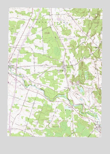
Richland, NY USGS Topographic Map
Click on map above to begin viewing in our Map Viewer.

This topographic map contains these locations and features:
Feature Name Type Latitude Longitude GNIS ID View Map
Adirondack Manor Assisted Living FacilityBuildingN43.5697°W76.1237°2715551View Map
AltmarPopulated PlaceN43.5101°W76.0021°942401View Map
Altmar Census Designated PlaceCensusN43.5111°W76.0037°2772072View Map
Altmar Fire DepartmentBuildingN43.5091°W76.0026°2700804View Map
Altmar Post OfficePost OfficeN43.5095°W76.0053°2713518View Map
Beulah Park CampgroundLocaleN43.5645°W76.0521°943817View Map
Blue Springs CemeteryCemeteryN43.5628°W76.0376°2542479View Map
Castor CemeteryCemeteryN43.5843°W76.0016°2542478View Map
Castor CornersLocaleN43.5873°W76.0044°946003View Map
CentervillePopulated PlaceN43.5478°W76.0444°946217View Map
Evergreen CemeteryCemeteryN43.5757°W76.0064°949766View Map
Greater Victory Fellowship ChurchChurchN43.5750°W76.0016°2714743View Map
Grindstone FarmLocaleN43.5078°W76.1072°2542323View Map
McClelland CemeteryCemeteryN43.5071°W76.1196°956740View Map
Northern Oswego County Ambulance ServiceBuildingN43.5686°W76.1174°2719260View Map
Noyes CemeteryCemeteryN43.5983°W76.0573°2369709View Map
Noyes WoodsWoodsN43.6014°W76.0500°2369718View Map
Orwell CreekStreamN43.5245°W76.0188°969292View Map
Oswego County at Pulaski HeliportAirportN43.5520°W76.0896°978247View Map
Pekin BrookStreamN43.5448°W76.0077°960104View Map
PinevillePopulated PlaceN43.5290°W76.0391°972950View Map
Potter CemeteryCemeteryN43.5609°W76.0027°961033View Map
Pulaski Airport (historical)AirportN43.5501°W76.1130°978246View Map
Pulaski Calvary Baptist ChurchChurchN43.5988°W76.1096°2714766View Map
Pulaski Junior - Senior High SchoolSchoolN43.5520°W76.1242°2713756View Map
Pulaski Village CemeteryCemeteryN43.5795°W76.1168°2542529View Map
RichlandPopulated PlaceN43.5695°W76.0477°962473View Map
Richland AirparkAirportN43.5715°W76.0401°978261View Map
Richland Christian ChurchChurchN43.5765°W76.0207°2714770View Map
Richland Post OfficePost OfficeN43.5714°W76.0507°2713533View Map
Richland Village CemeteryCemeteryN43.5687°W76.0539°2542476View Map
Richland Volunteer Fire DepartmentBuildingN43.5685°W76.0493°2734958View Map
Riverside CemeteryCemeteryN43.5509°W76.1041°962587View Map
Salmon River BridgeBridgeN43.5309°W76.0376°2715198View Map
Salmon River CemeteryCemeteryN43.5304°W76.0436°2542477View Map
School Number 13 (historical)SchoolN43.5689°W76.0903°2369716View Map
School Number 19 (historical)SchoolN43.5811°W76.0903°2369717View Map
School Number 2 (historical)SchoolN43.5875°W76.0033°2369710View Map
School Number 3 (historical)SchoolN43.5308°W76.0439°2369711View Map
School Number 4 (historical)SchoolN43.6089°W76.0667°2369712View Map
School Number 5 (historical)SchoolN43.5008°W76.0906°2369713View Map
School Number 5 (historical)SchoolN43.6128°W76.0383°2369714View Map
School Number 6 (historical)SchoolN43.5300°W76.0161°2369715View Map
Spring BrookStreamN43.5673°W76.1216°966054View Map
Stevens CemeteryCemeteryN43.6171°W76.0433°966379View Map
Stoney's Pineville CampgroundLocaleN43.5322°W76.0447°2715203View Map
Streamside Golf Course and Country ClubLocaleN43.5081°W76.1130°2715213View Map
The Church of Jesus Christ of Latter Day SaintsChurchN43.5749°W76.1200°2714782View Map
Trout BrookStreamN43.5395°W76.0480°967867View Map
Union SchoolSchoolN43.5148°W76.0044°968214View Map
Village of Altmar (historical)CivilN43.5111°W76.0037°2391512View Map

Note: Coordinates in the location and feature list above are referenced to NAD83 datum.


Copyright (C) 2008-2024 Ryan Niemi / Sunset Dynamics ... All Rights Reserved