TopoQuest Logo
Do you find TopoQuest useful?
Help keep TopoQuest running and adding new maps/features by donating!
Bitcoin:  19c7KJd3qBynnjoSw5npx9KScwjBe4ifkT
Litecoin:  LXs6TkuXGGXo1vDsWCkWVdjQX94eUKd6ui
Home View Maps Find Maps Find Places Resources & Links


Elm Park, Louisiana Topographic Map

USGS Map Title: Elm Park, LA
USGS Map MRC: 30091G3
DRG (GeoTIFF) Download: o30091g3.tif


Neighboring USGS Topographic Map Quads:


  Weyanoke, LA  
30091H4
 

  Laurel Hill, LA  
30091H3
 

  Rogillioville, LA  
30091H2
 

  Saint Francisville, LA  
30091G4
 

  Elm Park, LA  
30091G3
 

  Jackson, LA  
30091G2
 

  New Roads, LA  
30091F4
 

  Port Hudson, LA  
30091F3
 

  Zachary, LA  
30091F2


Map MRC Location:

N31°
W92°
N31°
W91°
H8 H7 H6 H5 H4 H3 H2 H1
G8 G7 G6 G5 G4 G3 G2 G1
F8 F7 F6 F5 F4 F3 F2 F1
E8 E7 E6 E5 E4 E3 E2 E1
D8 D7 D6 D5 D4 D3 D2 D1
C8 C7 C6 C5 C4 C3 C2 C1
B8 B7 B6 B5 B4 B3 B2 B1
A8 A7 A6 A5 A4 A3 A2 A1
N30°
W92°
N30°
W91°

Elm Park, LA USGS 1:24K Topographic Map Preview:
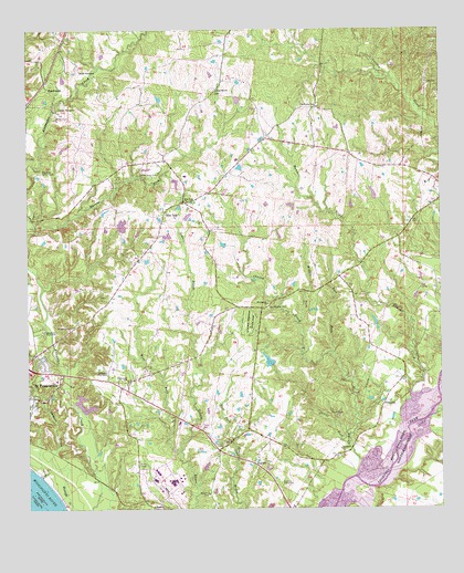
Elm Park, LA USGS Topographic Map
Click on map above to begin viewing in our Map Viewer.

This topographic map contains these locations and features:
Feature Name Type Latitude Longitude GNIS ID View Map
Ambrosia PlantationLocaleN30.7863°W91.3509°532150View Map
Audubon State Historic SiteParkN30.7991°W91.3079°553324View Map
Barrow ForkStreamN30.8227°W91.3729°532322View Map
BeachwoodPopulated PlaceN30.8599°W91.3687°553541View Map
Butler CemeteryCemeteryN30.8530°W91.3659°533585View Map
CarneyPopulated PlaceN30.8460°W91.3021°550167View Map
Chaney CreekStreamN30.7594°W91.2737°553880View Map
Chaney PlantationLocaleN30.7705°W91.2693°550170View Map
Cottage PlantationLocaleN30.8535°W91.3654°534158View Map
East Fork Caney CreekStreamN30.7902°W91.2832°534714View Map
Elm ParkPopulated PlaceN30.8263°W91.3343°543176View Map
Elm Park ChurchChurchN30.8305°W91.3279°534809View Map
Fairview PlantationLocaleN30.7563°W91.2984°554379View Map
Faith Hope and Love Fellowship CenterChurchN30.7793°W91.3743°2601630View Map
FreelandPopulated PlaceN30.7782°W91.2671°543221View Map
Gaspers CreekStreamN30.7591°W91.3715°554515View Map
HamiltonPopulated PlaceN30.8027°W91.3118°550178View Map
Hammer CreekStreamN30.7749°W91.2626°554652View Map
Healing Place ChurchChurchN30.7793°W91.3738°2601891View Map
Laurel ForkStreamN30.7685°W91.2782°536349View Map
Locust Grove CemeteryCemeteryN30.8374°W91.3354°536652View Map
Locust Grove Plantation (historical)LocaleN30.8377°W91.3357°550185View Map
Locust Grove State Historic SiteParkN30.8377°W91.3357°550186View Map
Magnolia ChurchChurchN30.7507°W91.3373°536837View Map
Marydale Scout CampLocaleN30.8380°W91.3709°555246View Map
McKowen ChurchChurchN30.8555°W91.2882°537007View Map
Middle Fork Caney CreekStreamN30.7988°W91.2934°537059View Map
Mount Pilgrim ChurchChurchN30.8035°W91.3026°537380View Map
Nauga FieldAirportN30.7617°W91.2764°2676799View Map
Parish Governing Authority District 2 (historical)CivilN30.8677°W91.2755°1929927View Map
Raspberry ChurchChurchN30.7657°W91.2804°538496View Map
Riverbend Nuclear PlantLocaleN30.7625°W91.3375°550192View Map
Rosale PlantationLocaleN30.8643°W91.3590°555831View Map
Rosedown ChurchChurchN30.7977°W91.3623°538715View Map
Rosedown PlantationLocaleN30.7957°W91.3707°538716View Map
Rosedown Plantation State Historic SiteParkN30.7960°W91.3709°1946040View Map
Rosenwald SchoolSchoolN30.7838°W91.3451°538722View Map
Sage Hill ChurchChurchN30.8593°W91.3179°538785View Map
Saint Francisville Post OfficePost OfficeN30.7790°W91.3733°1631458View Map
StarhillPopulated PlaceN30.7621°W91.3071°556137View Map
Starhill CemeteryCemeteryN30.7666°W91.3162°539627View Map
Starhill ChurchChurchN30.7544°W91.3204°539628View Map
Troy PlantationLocaleN30.7710°W91.3284°550198View Map
United Pentecostal ChurchChurchN30.7837°W91.3649°2602924View Map
Ward NineCivilN30.8430°W91.2887°545285View Map
Ward OneCivilN30.7827°W91.3740°545278View Map
Ward ThreeCivilN30.8427°W91.3671°545280View Map
Ward TwoCivilN30.7616°W91.3021°545279View Map
Washington CemeteryCemeteryN30.8024°W91.3023°540242View Map
West Feliciana Parish HospitalHospitalN30.7839°W91.3666°2674125View Map
West Fork Grants BayouStreamN30.7655°W91.3296°540320View Map

Note: Coordinates in the location and feature list above are referenced to NAD83 datum.


Copyright (C) 2008-2024 Ryan Niemi / Sunset Dynamics ... All Rights Reserved