TopoQuest Logo
Do you find TopoQuest useful?
Help keep TopoQuest running and adding new maps/features by donating!
Bitcoin:  19c7KJd3qBynnjoSw5npx9KScwjBe4ifkT
Litecoin:  LXs6TkuXGGXo1vDsWCkWVdjQX94eUKd6ui
Home View Maps Find Maps Find Places Resources & Links


Saint Francisville, Louisiana Topographic Map

USGS Map Title: Saint Francisville, LA
USGS Map MRC: 30091G4
DRG (GeoTIFF) Download: o30091g4.tif


Neighboring USGS Topographic Map Quads:


  Angola, LA  
30091H5
 

  Weyanoke, LA  
30091H4
 

  Laurel Hill, LA  
30091H3
 

  Lacour, LA  
30091G5
 

  Saint Francisville, LA  
30091G4
 

  Elm Park, LA  
30091G3
 

  Morganza, LA  
30091F5
 

  New Roads, LA  
30091F4
 

  Port Hudson, LA  
30091F3


Map MRC Location:

N31°
W92°
N31°
W91°
H8 H7 H6 H5 H4 H3 H2 H1
G8 G7 G6 G5 G4 G3 G2 G1
F8 F7 F6 F5 F4 F3 F2 F1
E8 E7 E6 E5 E4 E3 E2 E1
D8 D7 D6 D5 D4 D3 D2 D1
C8 C7 C6 C5 C4 C3 C2 C1
B8 B7 B6 B5 B4 B3 B2 B1
A8 A7 A6 A5 A4 A3 A2 A1
N30°
W92°
N30°
W91°

Saint Francisville, LA USGS 1:24K Topographic Map Preview:
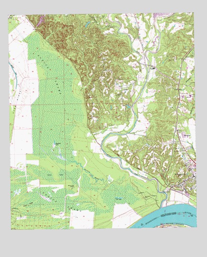
Saint Francisville, LA USGS Topographic Map
Click on map above to begin viewing in our Map Viewer.

This topographic map contains these locations and features:
Feature Name Type Latitude Longitude GNIS ID View Map
Afton Villa Baptist ChurchChurchN30.8479°W91.3824°2600520View Map
Afton Villa ChurchChurchN30.8513°W91.3759°532091View Map
BainsPopulated PlaceN30.8307°W91.3868°532281View Map
Bains Elementary SchoolSchoolN30.8270°W91.3781°1629568View Map
Bains Lower Elementary SchoolSchoolN30.8249°W91.3775°554194View Map
Bains Post OfficePost OfficeN30.8335°W91.3865°1631442View Map
Barrow CemeteryCemeteryN30.8477°W91.3882°532320View Map
Barrow CemeteryCemeteryN30.8727°W91.4373°532321View Map
Bayou SaraStreamN30.7618°W91.3990°553521View Map
Bayou SaraLocaleN30.7716°W91.3937°532768View Map
Bayou Sara BendBendN30.7591°W91.3821°550155View Map
Bayou Sara RevetmentLeveeN30.7632°W91.3798°550157View Map
Bear BayouStreamN30.8349°W91.4948°532823View Map
Bingen (historical)Populated PlaceN30.8607°W91.4751°550158View Map
Blackfork BayouStreamN30.7682°W91.4384°553701View Map
Blackfork LakeLakeN30.7995°W91.4702°553702View Map
Brown SloughGutN30.7774°W91.4807°533438View Map
Butler Lake DamDamN30.8185°W91.4101°556787View Map
Catalpa (historical)Populated PlaceN30.8535°W91.3768°550168View Map
Catalpa PlantationLocaleN30.8513°W91.3759°533821View Map
Cross BayouStreamN30.7841°W91.4498°534274View Map
Davis LakeSwampN30.7813°W91.4599°534409View Map
Davis Lake SloughGutN30.7741°W91.4573°534410View Map
First Baptist ChurchChurchN30.7863°W91.3784°1759784View Map
Fort Sainte Reine (historical)MilitaryN30.7625°W91.3972°550173View Map
Fulda (historical)Populated PlaceN30.7832°W91.4112°550174View Map
Grace CemeteryCemeteryN30.7763°W91.3871°535299View Map
Grace Episcopal ChurchChurchN30.7763°W91.3868°550175View Map
Grandmother's Buttons MuseumBuildingN30.7747°W91.3853°2603212View Map
Greater Bethel African Methodist Episcopal ChurchChurchN30.7864°W91.3783°2601815View Map
Hardwicks DitchCanalN30.7560°W91.4965°535522View Map
HardwoodPopulated PlaceN30.8063°W91.3840°543276View Map
Harrison LakeLakeN30.7542°W91.4474°554670View Map
Hebrew Rest CemeteryCemeteryN30.7963°W91.3840°535605View Map
Henderson CampLocaleN30.7774°W91.4923°535624View Map
Jack CreekStreamN30.8105°W91.4621°554848View Map
Lake PlattSwampN30.7681°W91.4758°555675View Map
Little Bayou SaraStreamN30.8408°W91.4064°555052View Map
Our Lady of Mount Carmel CemeteryCemeteryN30.7752°W91.3896°1759783View Map
Our Lady of Mount Carmel ChurchChurchN30.7746°W91.3898°1759782View Map
Parish Governing Authority District 1 (historical)CivilN30.7827°W91.3754°1929770View Map
Parish Governing Authority District 3 (historical)CivilN30.8337°W91.4639°1929987View Map
Peach RidgeRidgeN30.7641°W91.4887°538030View Map
Pilgrim Rest CemeteryCemeteryN30.7952°W91.3851°538141View Map
Polly CreekStreamN30.8593°W91.4879°555698View Map
Pugh LakeLakeN30.7679°W91.4273°555742View Map
Raspberry Baptist ChurchChurchN30.7783°W91.3822°2602427View Map
Ratliff LakeLakeN30.8427°W91.4968°555757View Map
Saint FrancisvillePopulated PlaceN30.7799°W91.3765°1630004View Map
Saint Francisville FerryCrossingN30.7580°W91.3951°550194View Map
Saint Francisville Police DepartmentBuildingN30.7795°W91.3767°2755263View Map
Saint Francisville Volunteer Fire DepartmentBuildingN30.7793°W91.3772°2672803View Map
Saint Luke ChurchChurchN30.8282°W91.4251°538944View Map
SolitudePopulated PlaceN30.8324°W91.4251°543678View Map
Solitude AirstripAirportN30.8719°W91.4352°2676758View Map
Spring BranchStreamN30.8657°W91.4259°539574View Map
Timberwheel LakesLakeN30.7643°W91.4546°556250View Map
Town of Saint FrancisvilleCivilN30.7851°W91.3787°2407267View Map
Tunica SwampSwampN30.8217°W91.4702°540024View Map
United Methodist ChurchChurchN30.7743°W91.3854°1759785View Map
Ward TenCivilN30.8255°W91.4571°545286View Map
West Feliciana High SchoolSchoolN30.8261°W91.3834°550204View Map
West Feliciana Historical Society MuseumBuildingN30.7777°W91.3819°2603290View Map
West Feliciana Middle SchoolSchoolN30.8292°W91.3841°2434753View Map
West Feliciana Parish Sheriff's OfficeBuildingN30.7753°W91.3864°2755308View Map
Wilcox (historical)Populated PlaceN30.8202°W91.3871°550203View Map
Woodriff DitchCanalN30.7699°W91.4065°540529View Map
Woodriff FallsFallsN30.7677°W91.4101°540530View Map

Note: Coordinates in the location and feature list above are referenced to NAD83 datum.


Copyright (C) 2008-2024 Ryan Niemi / Sunset Dynamics ... All Rights Reserved