TopoQuest Logo
Do you find TopoQuest useful?
Help keep TopoQuest running and adding new maps/features by donating!
Bitcoin:  19c7KJd3qBynnjoSw5npx9KScwjBe4ifkT
Litecoin:  LXs6TkuXGGXo1vDsWCkWVdjQX94eUKd6ui
Home View Maps Find Maps Find Places Resources & Links


Elmont, Kansas Topographic Map

USGS Map Title: Elmont, KS
USGS Map MRC: 39095B6
DRG (GeoTIFF) Download: o39095b6.tif


Neighboring USGS Topographic Map Quads:


  Soldier Creek SE, KS  
39095C7
 

  Mayetta, KS  
39095C6
 

  Holton SE, KS  
39095C5
 

  Grove, KS  
39095B7
 

  Elmont, KS  
39095B6
 

  Meriden, KS  
39095B5
 

  Silver Lake, KS  
39095A7
 

  Topeka, KS  
39095A6
 

  Grantville, KS  
39095A5


Map MRC Location:

N40°
W96°
N40°
W95°
H8 H7 H6 H5 H4 H3 H2 H1
G8 G7 G6 G5 G4 G3 G2 G1
F8 F7 F6 F5 F4 F3 F2 F1
E8 E7 E6 E5 E4 E3 E2 E1
D8 D7 D6 D5 D4 D3 D2 D1
C8 C7 C6 C5 C4 C3 C2 C1
B8 B7 B6 B5 B4 B3 B2 B1
A8 A7 A6 A5 A4 A3 A2 A1
N39°
W96°
N39°
W95°

Elmont, KS USGS 1:24K Topographic Map Preview:
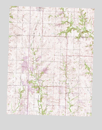
Elmont, KS USGS Topographic Map
Click on map above to begin viewing in our Map Viewer.

This topographic map contains these locations and features:
Feature Name Type Latitude Longitude GNIS ID View Map
Capital View Elementary School (historical)SchoolN39.1942°W95.6611°478466View Map
City of HoytCivilN39.2495°W95.7081°2394433View Map
ElmontPopulated PlaceN39.1653°W95.7030°478465View Map
Elmont Elementary SchoolSchoolN39.1624°W95.7030°2506609View Map
Elmont United Methodist ChurchChurchN39.1661°W95.7014°480348View Map
Family Life Church of the NazareneChurchN39.1274°W95.7304°2509437View Map
Grace Missionary Baptist ChurchChurchN39.1516°W95.6633°2509448View Map
Half - Day CemeteryCemeteryN39.1594°W95.7143°478463View Map
HoytPopulated PlaceN39.2478°W95.7064°478318View Map
Hoyt Baptist ChurchChurchN39.2463°W95.7068°2688699View Map
Hoyt CemeteryCemeteryN39.2436°W95.7378°478469View Map
Hoyt Police DepartmentBuildingN39.2485°W95.7047°2504207View Map
Hoyt Post OfficePost OfficeN39.2487°W95.7062°2510370View Map
Hoyt Rural Fire District 3BuildingN39.2492°W95.7042°2111431View Map
Hoyt United Methodist ChurchChurchN39.2493°W95.7067°2689450View Map
KMAJ-FM (Topeka)TowerN39.1903°W95.6583°481473View Map
Mesa Verde AirportAirportN39.1555°W95.7433°478464View Map
Middle Fork Muddy CreekStreamN39.2250°W95.6372°478316View Map
Northern Hills Baptist ChurchChurchN39.1587°W95.6756°478462View Map
Northside Church of ChristChurchN39.1289°W95.6684°480347View Map
Northview Mobile Home ParkPopulated PlaceN39.1497°W95.6625°2509802View Map
Pleasant Hill Elementary SchoolSchoolN39.1516°W95.6633°478461View Map
Pleasant Hill United Methodist ChurchChurchN39.1536°W95.6689°480346View Map
Rock SchoolSchoolN39.2386°W95.6544°478468View Map
Rolling Hills Christian ChurchChurchN39.1287°W95.7207°480349View Map
Royal Valley Elementary SchoolSchoolN39.2452°W95.7071°480311View Map
Royal Valley High SchoolSchoolN39.2449°W95.7059°480345View Map
Seaman High SchoolSchoolN39.1346°W95.6718°2506613View Map
Seaman Middle SchoolSchoolN39.1476°W95.6623°480350View Map
Shawnee County Indian Creek Wastewater Treatment PlantLocaleN39.1393°W95.6391°2510940View Map
Shawnee North Community CenterBuildingN39.1262°W95.6554°2510919View Map
Shawnee North Community Center Wastewater Treatment FacilityLocaleN39.1270°W95.6531°2510941View Map
Soldier Township Fire DepartmentBuildingN39.1298°W95.6689°2111890View Map
South Hoyt SchoolSchoolN39.2314°W95.7016°478467View Map
Steward CemeteryCemeteryN39.2311°W95.6366°485507View Map
Township of SoldierCivilN39.1554°W95.6601°478472View Map

Note: Coordinates in the location and feature list above are referenced to NAD83 datum.


Copyright (C) 2008-2024 Ryan Niemi / Sunset Dynamics ... All Rights Reserved