TopoQuest Logo
Do you find TopoQuest useful?
Help keep TopoQuest running and adding new maps/features by donating!
Bitcoin:  19c7KJd3qBynnjoSw5npx9KScwjBe4ifkT
Litecoin:  LXs6TkuXGGXo1vDsWCkWVdjQX94eUKd6ui
Home View Maps Find Maps Find Places Resources & Links


Mayetta, Kansas Topographic Map

USGS Map Title: Mayetta, KS
USGS Map MRC: 39095C6
DRG (GeoTIFF) Download: o39095c6.tif


Neighboring USGS Topographic Map Quads:


  Soldier Creek NE, KS  
39095D7
 

  Holton, KS  
39095D6
 

  Arrington, KS  
39095D5
 

  Soldier Creek SE, KS  
39095C7
 

  Mayetta, KS  
39095C6
 

  Holton SE, KS  
39095C5
 

  Grove, KS  
39095B7
 

  Elmont, KS  
39095B6
 

  Meriden, KS  
39095B5


Map MRC Location:

N40°
W96°
N40°
W95°
H8 H7 H6 H5 H4 H3 H2 H1
G8 G7 G6 G5 G4 G3 G2 G1
F8 F7 F6 F5 F4 F3 F2 F1
E8 E7 E6 E5 E4 E3 E2 E1
D8 D7 D6 D5 D4 D3 D2 D1
C8 C7 C6 C5 C4 C3 C2 C1
B8 B7 B6 B5 B4 B3 B2 B1
A8 A7 A6 A5 A4 A3 A2 A1
N39°
W96°
N39°
W95°

Mayetta, KS USGS 1:24K Topographic Map Preview:
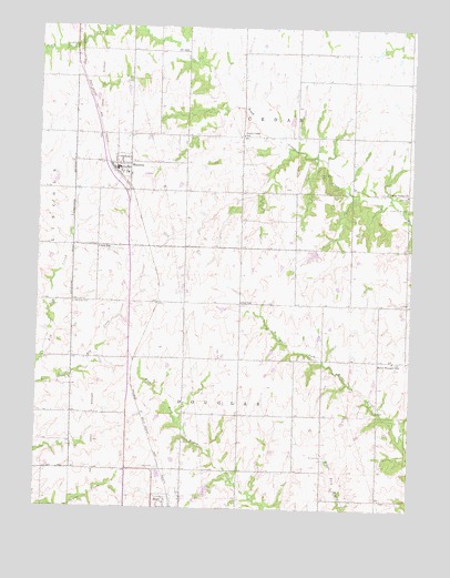
Mayetta, KS USGS Topographic Map
Click on map above to begin viewing in our Map Viewer.

This topographic map contains these locations and features:
Feature Name Type Latitude Longitude GNIS ID View Map
Bell SchoolSchoolN39.3175°W95.7300°478309View Map
Cedar Grove CemeteryCemeteryN39.3371°W95.6564°478305View Map
Cedar Valley ChurchChurchN39.3319°W95.6269°478306View Map
City of MayettaCivilN39.3385°W95.7211°2395050View Map
Hoyt Elementary School (historical)SchoolN39.2522°W95.7025°480312View Map
Hoyt Rural Water District Wastewater Treatment FacilityLocaleN39.2588°W95.7080°2691954View Map
MayettaPopulated PlaceN39.3389°W95.7225°478308View Map
Mayetta CemeteryCemeteryN39.3031°W95.7375°478311View Map
Mayetta Christian ChurchChurchN39.3395°W95.7215°2688737View Map
Mayetta Elementary SchoolSchoolN39.3367°W95.7222°470103View Map
Mayetta Police DepartmentBuildingN39.3380°W95.7236°2504212View Map
Mayetta Post OfficePost OfficeN39.3380°W95.7241°2693848View Map
Mayetta Rural Fire District 1BuildingN39.3394°W95.7225°2111597View Map
Mayetta Sewer Treatment PlantLocaleN39.3365°W95.7133°2691950View Map
Point Pleasant School (historical)SchoolN39.2883°W95.6311°478313View Map
Prairie Band Potawatomi Nation Government CenterBuildingN39.3414°W95.7393°2693204View Map
Prairie Band Potawatomi Tribal Police DepartmentBuildingN39.3424°W95.7376°2504150View Map
Ray SchoolSchoolN39.3036°W95.6822°478310View Map
Royal Valley Middle SchoolSchoolN39.3363°W95.7193°2506507View Map
Royal Valley Unified School District OfficeSchoolN39.3378°W95.7249°2506459View Map
Saint Francis Xavier ChurchChurchN39.3367°W95.7209°2688760View Map
Saint Joseph's Catholic CemeteryCemeteryN39.2602°W95.7095°478314View Map
South Cedar (historical)LocaleN39.3464°W95.6822°482260View Map
South Cedar CemeteryCemeteryN39.3288°W95.6269°478307View Map
South Cedar School (historical)SchoolN39.3469°W95.6822°478304View Map
Township of CedarCivilN39.3541°W95.6636°478197View Map
Township of DouglasCivilN39.2632°W95.6778°478303View Map

Note: Coordinates in the location and feature list above are referenced to NAD83 datum.


Copyright (C) 2008-2024 Ryan Niemi / Sunset Dynamics ... All Rights Reserved