TopoQuest Logo
Do you find TopoQuest useful?
Help keep TopoQuest running and adding new maps/features by donating!
Bitcoin:  19c7KJd3qBynnjoSw5npx9KScwjBe4ifkT
Litecoin:  LXs6TkuXGGXo1vDsWCkWVdjQX94eUKd6ui
Home View Maps Find Maps Find Places Resources & Links


Meriden, Kansas Topographic Map

USGS Map Title: Meriden, KS
USGS Map MRC: 39095B5
DRG (GeoTIFF) Download: o39095b5.tif


Neighboring USGS Topographic Map Quads:


  Mayetta, KS  
39095C6
 

  Holton SE, KS  
39095C5
 

  Valley Falls, KS  
39095C4
 

  Elmont, KS  
39095B6
 

  Meriden, KS  
39095B5
 

  Ozawkie, KS  
39095B4
 

  Topeka, KS  
39095A6
 

  Grantville, KS  
39095A5
 

  Perry, KS  
39095A4


Map MRC Location:

N40°
W96°
N40°
W95°
H8 H7 H6 H5 H4 H3 H2 H1
G8 G7 G6 G5 G4 G3 G2 G1
F8 F7 F6 F5 F4 F3 F2 F1
E8 E7 E6 E5 E4 E3 E2 E1
D8 D7 D6 D5 D4 D3 D2 D1
C8 C7 C6 C5 C4 C3 C2 C1
B8 B7 B6 B5 B4 B3 B2 B1
A8 A7 A6 A5 A4 A3 A2 A1
N39°
W96°
N39°
W95°

Meriden, KS USGS 1:24K Topographic Map Preview:
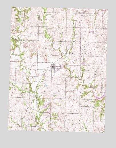
Meriden, KS USGS Topographic Map
Click on map above to begin viewing in our Map Viewer.

This topographic map contains these locations and features:
Feature Name Type Latitude Longitude GNIS ID View Map
Adam RanchLocaleN39.1446°W95.6096°2728846View Map
Anderson Mobile Home ParkPopulated PlaceN39.1397°W95.5657°2509661View Map
Blackhawk AirportAirportN39.1563°W95.5778°2651087View Map
Buena Terra AirportAirportN39.1549°W95.6092°2651044View Map
City of MeridenCivilN39.1896°W95.5677°2395102View Map
Claywell CreekStreamN39.1783°W95.5322°478475View Map
Cotton - O'Neil Meriden ClinicHospitalN39.1871°W95.5641°2509680View Map
Dix SchoolSchoolN39.2139°W95.5528°478478View Map
Durand's GreenhouseBuildingN39.1808°W95.5557°2509584View Map
East Fork Muddy CreekStreamN39.2158°W95.6155°478315View Map
Elm CreekStreamN39.1644°W95.5947°478476View Map
Fin and Feather LakeReservoirN39.1714°W95.5789°478473View Map
Jackson Farmers Grain Elevator Number 5LocaleN39.1923°W95.5703°2695301View Map
Jefferson West Elementary SchoolSchoolN39.1904°W95.5655°2506585View Map
Jefferson West High SchoolSchoolN39.1936°W95.5601°2506625View Map
Jefferson West Middle SchoolSchoolN39.1926°W95.5605°2506373View Map
Jefferson West Unified School District Central OfficeSchoolN39.1875°W95.5613°2506454View Map
Kilmer (historical)LocaleN39.1464°W95.6039°482584View Map
MeridenPopulated PlaceN39.1889°W95.5697°478474View Map
Meriden CemeteryCemeteryN39.1952°W95.5603°2673282View Map
Meriden Community LibraryBuildingN39.1906°W95.5687°2509913View Map
Meriden Police DepartmentBuildingN39.1907°W95.5706°2503903View Map
Meriden Post OfficePost OfficeN39.1910°W95.5711°2510287View Map
Meriden Sewer Treatment PlantLocaleN39.1907°W95.5766°2511244View Map
Rock CreekPopulated PlaceN39.2458°W95.5372°478479View Map
Rock CreekStreamN39.1675°W95.5180°478328View Map
Rock Creek Township Fire DepartmentBuildingN39.1897°W95.5623°2111796View Map
Saint Aloysius Catholic ChurchChurchN39.1867°W95.5588°2509457View Map
Saint Aloysius CemeteryCemeteryN39.1870°W95.5799°2673285View Map
Sunbeam School (historical)SchoolN39.1442°W95.6130°478477View Map
Tick CreekStreamN39.1989°W95.5541°478327View Map
Township of Rock CreekCivilN39.2231°W95.5432°478329View Map
Village Greens Golf CourseLocaleN39.2273°W95.5222°2509800View Map
West Fork Muddy CreekStreamN39.2158°W95.6155°478317View Map

Note: Coordinates in the location and feature list above are referenced to NAD83 datum.


Copyright (C) 2008-2024 Ryan Niemi / Sunset Dynamics ... All Rights Reserved