TopoQuest Logo
Do you find TopoQuest useful?
Help keep TopoQuest running and adding new maps/features by donating!
Bitcoin:  19c7KJd3qBynnjoSw5npx9KScwjBe4ifkT
Litecoin:  LXs6TkuXGGXo1vDsWCkWVdjQX94eUKd6ui
Home View Maps Find Maps Find Places Resources & Links


Elmore, Alabama Topographic Map

USGS Map Title: Elmore, AL
USGS Map MRC: 32086E3
DRG (GeoTIFF) Download: o32086e3.tif


Neighboring USGS Topographic Map Quads:


  Marbury, AL  
32086F4
 

  Holtville, AL  
32086F3
 

  Dexter, AL  
32086F2
 

  Deatsville, AL  
32086E4
 

  Elmore, AL  
32086E3
 

  Wetumpka, AL  
32086E2
 

  Prattville, AL  
32086D4
 

  Montgomery North, AL  
32086D3
 

  Willow Springs, AL  
32086D2


Map MRC Location:

N33°
W87°
N33°
W86°
H8 H7 H6 H5 H4 H3 H2 H1
G8 G7 G6 G5 G4 G3 G2 G1
F8 F7 F6 F5 F4 F3 F2 F1
E8 E7 E6 E5 E4 E3 E2 E1
D8 D7 D6 D5 D4 D3 D2 D1
C8 C7 C6 C5 C4 C3 C2 C1
B8 B7 B6 B5 B4 B3 B2 B1
A8 A7 A6 A5 A4 A3 A2 A1
N32°
W87°
N32°
W86°

Elmore, AL USGS 1:24K Topographic Map Preview:
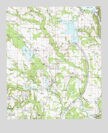
Elmore, AL USGS Topographic Map
Click on map above to begin viewing in our Map Viewer.

This topographic map contains these locations and features:
Feature Name Type Latitude Longitude GNIS ID View Map
Adkin HillPopulated PlaceN32.6090°W86.3111°112934View Map
Adkin Hill ChurchChurchN32.6076°W86.3039°168500View Map
Alabama River CanalCanalN32.5568°W86.2658°137133View Map
Atoka Station (historical)LocaleN32.5465°W86.2639°137137View Map
B D Greer DamDamN32.5168°W86.2833°130652View Map
Bibbs CemeteryCemeteryN32.5007°W86.3391°154987View Map
BroadmoorPopulated PlaceN32.5093°W86.3500°137150View Map
Callaway CreekStreamN32.5151°W86.2775°155005View Map
City of MillbrookCivilN32.5034°W86.3728°2404261View Map
Cold SpringPopulated PlaceN32.6090°W86.3680°155036View Map
Cold Springs ChurchChurchN32.6099°W86.3522°155404View Map
Coosada CemeteryCemeteryN32.5071°W86.3483°116599View Map
Coosada Elementary School (historical)SchoolN32.5096°W86.3255°154695View Map
Cottonford CreekStreamN32.5340°W86.3225°116692View Map
Crenshaw School (historical)SchoolN32.5960°W86.2583°137176View Map
Dead RiverStreamN32.5015°W86.2666°117161View Map
Draper Correctional FacilityBuildingN32.5764°W86.3360°137181View Map
Ebenezer CemeteryCemeteryN32.6196°W86.3416°1730360View Map
Ebenezer ChurchChurchN32.6193°W86.3414°117837View Map
Edgewood AcademySchoolN32.5468°W86.2861°137185View Map
ElmorePopulated PlaceN32.5387°W86.3150°117956View Map
Elmore Bible ChapelChurchN32.5371°W86.3141°137186View Map
Elmore ChurchChurchN32.5690°W86.3211°143073View Map
Elmore Church of ChristChurchN32.5426°W86.3064°137187View Map
Elmore Correctional FacilityBuildingN32.5747°W86.3208°2739751View Map
Elmore DivisionCivilN32.5044°W86.3534°165760View Map
Elmore Elmentary School (historical)SchoolN32.5382°W86.3077°154696View Map
Elmore Post OfficePost OfficeN32.5408°W86.3153°168499View Map
Elmore Volunteer Fire Department Station 1BuildingN32.5416°W86.3126°2691267View Map
Elmore Volunteer Fire Department Station 2BuildingN32.5618°W86.3147°2691352View Map
Fitzpatrick School (historical)SchoolN32.5501°W86.2855°137201View Map
Fort Jackson (historical)MilitaryN32.5042°W86.2564°1680819View Map
Fort Toulouse (historical)MilitaryN32.5042°W86.2556°1680994View Map
Fort Toulouse National Historic ParkParkN32.5004°W86.2502°137203View Map
Fort Toulouse State ParkParkN32.5029°W86.2555°154690View Map
Greer LakeReservoirN32.5168°W86.2833°130651View Map
Harris ChapelChurchN32.5254°W86.3700°119802View Map
Holtville ChurchChurchN32.6157°W86.2764°155104View Map
Holy Assembly Church of Jesus ChristChurchN32.5457°W86.2541°154691View Map
Hurricane BranchStreamN32.6043°W86.3286°137228View Map
Jones CemeteryCemeteryN32.5593°W86.3655°120998View Map
Jones ChapelChurchN32.5540°W86.3705°155118View Map
Jordan DamDamN32.6187°W86.2574°151927View Map
Jordan LakeReservoirN32.6183°W86.2572°121053View Map
Jordan Lake DiversionReservoirN32.5768°W86.2783°130716View Map
Liberty Hill ChurchChurchN32.5812°W86.2594°121575View Map
Log LandingLocaleN32.5237°W86.2552°163437View Map
Middle CreekStreamN32.5343°W86.3264°122685View Map
Millbrook Fire Department Station 2BuildingN32.5212°W86.3748°2691371View Map
Mitts ChapelChurchN32.6101°W86.3536°152352View Map
Mortar CreekStreamN32.5074°W86.3022°155157View Map
Mount Hebron West Baptist ChurchChurchN32.5601°W86.3236°155407View Map
Mount Hebron West CemeteryCemeteryN32.5590°W86.3230°1730363View Map
Mount Zion (historical)LocaleN32.5335°W86.3152°137268View Map
Mount Zion ChapelChurchN32.5971°W86.2758°123433View Map
New Home CemeteryCemeteryN32.5504°W86.2866°1730365View Map
New Home Missionary Baptist ChurchChurchN32.5504°W86.2889°155169View Map
North ElmorePopulated PlaceN32.5565°W86.3191°123992View Map
Odshiapofa (historical)LocaleN32.5210°W86.2555°166068View Map
Okchayudshi (historical)LocaleN32.5140°W86.2527°158145View Map
Overton HeightsPopulated PlaceN32.5090°W86.3464°137281View Map
Pakana (historical)LocaleN32.5099°W86.2514°137282View Map
Parker Ferry (historical)CrossingN32.5062°W86.3014°137283View Map
Parker IslandIslandN32.5004°W86.2916°137284View Map
Pine Grove ChurchChurchN32.5162°W86.3247°124804View Map
Robinson Primary SchoolSchoolN32.5118°W86.3730°137302View Map
SpeignerPopulated PlaceN32.5840°W86.3447°155252View Map
Speigner DamDamN32.5691°W86.3414°130705View Map
Speigner LakeReservoirN32.5735°W86.3467°127176View Map
SpringdalePopulated PlaceN32.5051°W86.3694°137322View Map
SpringfieldPopulated PlaceN32.5182°W86.3747°137323View Map
Staton Correctional FacilityBuildingN32.5770°W86.3330°2739754View Map
Sunny Hill School (historical)SchoolN32.5496°W86.2964°137326View Map
Sweetening Junior High SchoolSchoolN32.5565°W86.3697°165554View Map
Tallapoosa RiverStreamN32.5026°W86.2633°160710View Map
Taskigi MoundSummitN32.5040°W86.2586°154699View Map
Thrasher CemeteryCemeteryN32.6051°W86.2758°137335View Map
Tomonpa (historical)LocaleN32.5140°W86.2583°155410View Map
Town of ElmoreCivilN32.5420°W86.3173°2406444View Map
Tuskugu (historical)Populated PlaceN32.5043°W86.2541°158147View Map
Union Rosenwald SchoolSchoolN32.5968°W86.2836°128348View Map
W A Williamson DamDamN32.5135°W86.3700°130648View Map
Walter Bouldin DamDamN32.5768°W86.2783°130715View Map
Wetumpka Institute (historical)SchoolN32.5590°W86.2530°137353View Map
Wetumpka Municipal AirportAirportN32.5303°W86.3291°129439View Map
Williamsons LakeReservoirN32.5138°W86.3714°130649View Map

Note: Coordinates in the location and feature list above are referenced to NAD83 datum.


Copyright (C) 2008-2025 Ryan Niemi / Sunset Dynamics ... All Rights Reserved