TopoQuest Logo
Do you find TopoQuest useful?
Help keep TopoQuest running and adding new maps/features by donating!
Bitcoin:  19c7KJd3qBynnjoSw5npx9KScwjBe4ifkT
Litecoin:  LXs6TkuXGGXo1vDsWCkWVdjQX94eUKd6ui
Home View Maps Find Maps Find Places Resources & Links


Marbury, Alabama Topographic Map

USGS Map Title: Marbury, AL
USGS Map MRC: 32086F4
DRG (GeoTIFF) Download: o32086f4.tif


Neighboring USGS Topographic Map Quads:


  Clanton East, AL  
32086G5
 

  Mitchell Dam, AL  
32086G4
 

  Richville, AL  
32086G3
 

  White City, AL  
32086F5
 

  Marbury, AL  
32086F4
 

  Holtville, AL  
32086F3
 

  Old Kingston, AL  
32086E5
 

  Deatsville, AL  
32086E4
 

  Elmore, AL  
32086E3


Map MRC Location:

N33°
W87°
N33°
W86°
H8 H7 H6 H5 H4 H3 H2 H1
G8 G7 G6 G5 G4 G3 G2 G1
F8 F7 F6 F5 F4 F3 F2 F1
E8 E7 E6 E5 E4 E3 E2 E1
D8 D7 D6 D5 D4 D3 D2 D1
C8 C7 C6 C5 C4 C3 C2 C1
B8 B7 B6 B5 B4 B3 B2 B1
A8 A7 A6 A5 A4 A3 A2 A1
N32°
W87°
N32°
W86°

Marbury, AL USGS 1:24K Topographic Map Preview:
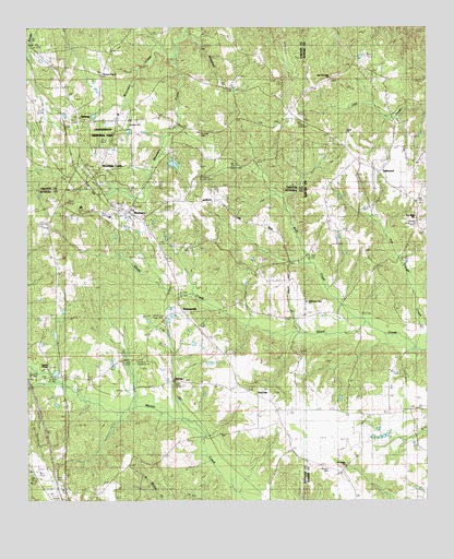
Marbury, AL USGS Topographic Map
Click on map above to begin viewing in our Map Viewer.

This topographic map contains these locations and features:
Feature Name Type Latitude Longitude GNIS ID View Map
Antioch ChurchChurchN32.6982°W86.4941°113149View Map
Bethlehem West ChurchChurchN32.6774°W86.4128°116735View Map
Canaan CemeteryCemeteryN32.7246°W86.4689°115517View Map
Confederate Memorial ParkParkN32.7210°W86.4708°136677View Map
Congregational Holiness CampgroundLocaleN32.6307°W86.4811°147544View Map
Cornerstone ChurchChurchN32.6596°W86.4886°147546View Map
Gates Mill (historical)LocaleN32.6599°W86.4889°147565View Map
Jo Anna CemeteryCemeteryN32.7226°W86.4452°143017View Map
Jo Anna ChurchChurchN32.7229°W86.4411°120898View Map
Liberty ChurchChurchN32.7221°W86.4053°121562View Map
Lightfoot DamDamN32.7135°W86.4533°130935View Map
Lightfoot LakeReservoirN32.7140°W86.4540°130936View Map
LightwoodPopulated PlaceN32.7118°W86.3891°121610View Map
Lightwood Junior High SchoolSchoolN32.7004°W86.3772°165467View Map
Lightwood Volunteer Fire DepartmentBuildingN32.7001°W86.3774°2691197View Map
MarburyPopulated PlaceN32.7012°W86.4711°152222View Map
Marbury Baptist Church CemeteryCemeteryN32.7037°W86.4727°1805677View Map
Marbury Census Designated PlaceCensusN32.6793°W86.4607°2582686View Map
Marbury Church of God CemeteryCemeteryN32.7048°W86.4897°1805674View Map
Marbury Fire DepartmentBuildingN32.6729°W86.4482°2691123View Map
Marbury Post OfficePost OfficeN32.7025°W86.4708°167093View Map
Marbury SchoolSchoolN32.6996°W86.4739°147588View Map
Memorial CemeteryCemeteryN32.7210°W86.4711°152300View Map
MidwayPopulated PlaceN32.7254°W86.4839°152314View Map
Midway CemeteryCemeteryN32.7254°W86.4853°151274View Map
Midway Church of ChristChurchN32.7254°W86.4847°154296View Map
Morning Star CemeteryCemeteryN32.7379°W86.4769°151275View Map
Morning Star ChurchChurchN32.7379°W86.4766°123063View Map
Mount Pisgah ChurchChurchN32.7035°W86.4833°147594View Map
Mount Zion CemeteryCemeteryN32.6329°W86.4058°123432View Map
Mountain CreekPopulated PlaceN32.7107°W86.4789°152547View Map
Mountain Creek Baptist ChurchChurchN32.7126°W86.4783°151273View Map
Mountain Creek CemeteryCemeteryN32.7129°W86.4800°151272View Map
Myrick ChapelChurchN32.6599°W86.4928°152578View Map
New Harmony CemeteryCemeteryN32.7360°W86.4050°1730364View Map
New Harmony ChurchChurchN32.7371°W86.4050°155168View Map
New Hope CemeteryCemeteryN32.6968°W86.3783°1730366View Map
New Hope ChurchChurchN32.6990°W86.3780°123845View Map
Pine FlatPopulated PlaceN32.6543°W86.4311°156891View Map
PyronPopulated PlaceN32.7024°W86.4939°147638View Map
RollinsPopulated PlaceN32.6571°W86.4550°147640View Map
Saint James ChurchChurchN32.6337°W86.4011°126109View Map
Saint James School (historical)SchoolN32.6357°W86.4000°137310View Map
Saint Paul African Methodist Episcopal ChurchChurchN32.7074°W86.4672°151282View Map
Saint Paul CemeteryCemeteryN32.7076°W86.4675°151283View Map
Union ChurchChurchN32.7221°W86.3989°128303View Map
WadsworthPopulated PlaceN32.6749°W86.4508°128490View Map
Wadsworth Baptist ChurchChurchN32.6746°W86.4494°154284View Map
West Mountain CreekStreamN32.7432°W86.4536°128789View Map
Wilder Hill (historical)Populated PlaceN32.6340°W86.4950°147674View Map
Wolf CreekStreamN32.6718°W86.3928°129159View Map

Note: Coordinates in the location and feature list above are referenced to NAD83 datum.


Copyright (C) 2008-2024 Ryan Niemi / Sunset Dynamics ... All Rights Reserved