TopoQuest Logo
Do you find TopoQuest useful?
Help keep TopoQuest running and adding new maps/features by donating!
Bitcoin:  19c7KJd3qBynnjoSw5npx9KScwjBe4ifkT
Litecoin:  LXs6TkuXGGXo1vDsWCkWVdjQX94eUKd6ui
Home View Maps Find Maps Find Places Resources & Links


Holtville, Alabama Topographic Map

USGS Map Title: Holtville, AL
USGS Map MRC: 32086F3
DRG (GeoTIFF) Download: o32086f3.tif


Neighboring USGS Topographic Map Quads:


  Mitchell Dam, AL  
32086G4
 

  Richville, AL  
32086G3
 

  Rockford SW, AL  
32086G2
 

  Marbury, AL  
32086F4
 

  Holtville, AL  
32086F3
 

  Dexter, AL  
32086F2
 

  Deatsville, AL  
32086E4
 

  Elmore, AL  
32086E3
 

  Wetumpka, AL  
32086E2


Map MRC Location:

N33°
W87°
N33°
W86°
H8 H7 H6 H5 H4 H3 H2 H1
G8 G7 G6 G5 G4 G3 G2 G1
F8 F7 F6 F5 F4 F3 F2 F1
E8 E7 E6 E5 E4 E3 E2 E1
D8 D7 D6 D5 D4 D3 D2 D1
C8 C7 C6 C5 C4 C3 C2 C1
B8 B7 B6 B5 B4 B3 B2 B1
A8 A7 A6 A5 A4 A3 A2 A1
N32°
W87°
N32°
W86°

Holtville, AL USGS 1:24K Topographic Map Preview:
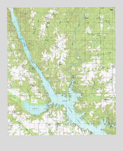
Holtville, AL USGS Topographic Map
Click on map above to begin viewing in our Map Viewer.

This topographic map contains these locations and features:
Feature Name Type Latitude Longitude GNIS ID View Map
Bensons Mill (historical)LocaleN32.6535°W86.3436°143016View Map
Big BranchStreamN32.7062°W86.3550°137145View Map
BuyckPopulated PlaceN32.7046°W86.2569°157906View Map
Buyck ChurchChurchN32.7071°W86.2527°137152View Map
Buyck Volunteer Fire Department Station 1BuildingN32.6752°W86.2516°2691086View Map
Buyck Volunteer Fire Department Station 2BuildingN32.6972°W86.2549°2691363View Map
Camp ChandlerLocaleN32.6349°W86.2583°115475View Map
Coosa RiverPopulated PlaceN32.6479°W86.3697°116596View Map
Coosa River ChurchChurchN32.6487°W86.3675°137170View Map
Deatsville DivisionCivilN32.6430°W86.3568°165758View Map
Dunlap CreekStreamN32.7251°W86.2961°117675View Map
Friendship ChurchChurchN32.6943°W86.3153°118715View Map
Gennie BranchStreamN32.6529°W86.3491°137207View Map
Harmony ChurchChurchN32.7346°W86.3289°119763View Map
Hogbed CreekStreamN32.6535°W86.3486°120201View Map
Holman CemeteryCemeteryN32.6923°W86.2502°120288View Map
HoltvillePopulated PlaceN32.6362°W86.3266°120302View Map
Holtville - Slapout Fire and RescueBuildingN32.6346°W86.3199°2691351View Map
Holtville Census Designated PlaceCensusN32.6314°W86.3267°2582683View Map
Holtville High SchoolSchoolN32.6357°W86.3264°137224View Map
Holtville ParkParkN32.6499°W86.3289°120303View Map
Jake CreekStreamN32.7271°W86.3636°120801View Map
Lake Hill ChurchChurchN32.6674°W86.3391°121320View Map
Lebanon Baptist ChurchChurchN32.6790°W86.2544°158001View Map
Little York Post Office (historical)Post OfficeN32.6293°W86.3111°166067View Map
Morris Ferry (historical)CrossingN32.7001°W86.3478°137264View Map
Mount Pisgah ChurchChurchN32.6612°W86.2552°123348View Map
Mount Pisgah ChurchChurchN32.6662°W86.2533°137267View Map
Mount Pisgah SchoolSchoolN32.6662°W86.2672°123349View Map
New Home Assembly of God ChurchChurchN32.7024°W86.2711°155170View Map
Nobles Ferry (historical)CrossingN32.6918°W86.3414°137276View Map
Pinkston CreekStreamN32.6632°W86.2969°152949View Map
Providence Methodist ChurchChurchN32.7365°W86.2591°158061View Map
Rivers ChapelChurchN32.7396°W86.3266°155216View Map
Sewell CemeteryCemeteryN32.7071°W86.2777°153375View Map
Sewell Memorial Junior High SchoolSchoolN32.6943°W86.2761°165527View Map
Shoal CreekStreamN32.6574°W86.3236°153438View Map
Sofkahatchee CreekStreamN32.6312°W86.2669°158088View Map
Speigner CemeteryCemeteryN32.6840°W86.2833°137321View Map
Sykes Mill (historical)LocaleN32.7418°W86.2841°158146View Map
Tan Trough CreekStreamN32.6649°W86.3728°127659View Map
TitusPopulated PlaceN32.7124°W86.3183°128000View Map
Titus Post OfficePost OfficeN32.7117°W86.3185°168478View Map
Titus Volunteer Fire Department Station 1BuildingN32.7105°W86.3179°2691373View Map
Titus Volunteer Fire Department Station 2BuildingN32.6494°W86.2782°2691355View Map
Town CreekStreamN32.6985°W86.3455°153709View Map
Trash BranchStreamN32.7174°W86.3597°137339View Map
Wadsworths Old Ferry (historical)CrossingN32.7257°W86.3611°137347View Map
Welona CreekStreamN32.7118°W86.3519°128736View Map
Weoka CreekStreamN32.6554°W86.3014°153927View Map
Weoka MillsPopulated PlaceN32.6818°W86.3005°157234View Map
Woods Store (historical)LocaleN32.7379°W86.2833°137357View Map

Note: Coordinates in the location and feature list above are referenced to NAD83 datum.


Copyright (C) 2008-2025 Ryan Niemi / Sunset Dynamics ... All Rights Reserved