TopoQuest Logo
Do you find TopoQuest useful?
Help keep TopoQuest running and adding new maps/features by donating!
Bitcoin:  19c7KJd3qBynnjoSw5npx9KScwjBe4ifkT
Litecoin:  LXs6TkuXGGXo1vDsWCkWVdjQX94eUKd6ui
Home View Maps Find Maps Find Places Resources & Links


Elwood, Texas Topographic Map

USGS Map Title: Elwood, TX
USGS Map MRC: 31095A7
DRG (GeoTIFF) Download: o31095a7.tif


Neighboring USGS Topographic Map Quads:


  Leona, TX  
31095B8
 

  Middleton, TX  
31095B7
 

  Austonio, TX  
31095B6
 

  Leona SW, TX  
31095A8
 

  Elwood, TX  
31095A7
 

  Sand Ridge, TX  
31095A6
 

  Madisonville, TX  
30095H8
 

  Connor, TX  
30095H7
 

  Baker Lake, TX  
30095H6


Map MRC Location:

N32°
W96°
N32°
W95°
H8 H7 H6 H5 H4 H3 H2 H1
G8 G7 G6 G5 G4 G3 G2 G1
F8 F7 F6 F5 F4 F3 F2 F1
E8 E7 E6 E5 E4 E3 E2 E1
D8 D7 D6 D5 D4 D3 D2 D1
C8 C7 C6 C5 C4 C3 C2 C1
B8 B7 B6 B5 B4 B3 B2 B1
A8 A7 A6 A5 A4 A3 A2 A1
N31°
W96°
N31°
W95°

Elwood, TX USGS 1:24K Topographic Map Preview:
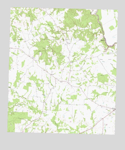
Elwood, TX USGS Topographic Map
Click on map above to begin viewing in our Map Viewer.

This topographic map contains these locations and features:
Feature Name Type Latitude Longitude GNIS ID View Map
Alphin CemeteryCemeteryN31.0449°W95.8230°1351042View Map
Big Dickey LakeLakeN31.0376°W95.8320°1352056View Map
Black Oak BranchStreamN31.0791°W95.7838°1352348View Map
Boggy CreekStreamN31.1205°W95.7763°1352582View Map
Camp BranchStreamN31.0446°W95.8722°1353613View Map
City of MidwayCivilN31.0252°W95.7538°2411100View Map
Cobb CreekStreamN31.1027°W95.7666°1354711View Map
Convict BranchStreamN31.1088°W95.8730°1354893View Map
DingervillePopulated PlaceN31.0738°W95.8466°1379665View Map
ElwoodPopulated PlaceN31.0588°W95.8255°1379723View Map
Goose PrairieFlatN31.0752°W95.7619°1358179View Map
Harbuck BranchStreamN31.0180°W95.8297°1358756View Map
Henesy BranchStreamN31.0999°W95.8125°1359035View Map
Little Spring BranchStreamN31.1135°W95.8711°1361478View Map
MidwayPopulated PlaceN31.0260°W95.7505°1362795View Map
Midway Post OfficePost OfficeN31.0199°W95.7579°2731811View Map
Myrtle CreekStreamN31.0235°W95.8441°1363565View Map
Old ElwoodPopulated PlaceN31.0719°W95.8030°1380295View Map
Person BranchStreamN31.0121°W95.8216°1365096View Map
Slaughter LakeReservoirN31.0059°W95.7618°1863884View Map
Slaughter Lake DamDamN31.0052°W95.7619°1863883View Map
Tan YardLocaleN31.0913°W95.8072°1369574View Map
Tan Yard CemeteryCemeteryN31.0785°W95.8002°1369575View Map
The CanyonValleyN31.0883°W95.7590°1369771View Map
Westmoreland BranchStreamN31.0132°W95.8277°1371300View Map
Wilson ChapelChurchN31.1188°W95.8288°1371711View Map

Note: Coordinates in the location and feature list above are referenced to NAD83 datum.


Copyright (C) 2008-2025 Ryan Niemi / Sunset Dynamics ... All Rights Reserved