TopoQuest Logo
Do you find TopoQuest useful?
Help keep TopoQuest running and adding new maps/features by donating!
Bitcoin:  19c7KJd3qBynnjoSw5npx9KScwjBe4ifkT
Litecoin:  LXs6TkuXGGXo1vDsWCkWVdjQX94eUKd6ui
Home View Maps Find Maps Find Places Resources & Links


Connor, Texas Topographic Map

USGS Map Title: Connor, TX
USGS Map MRC: 30095H7
DRG (GeoTIFF) Download: o30095h7.tif


Neighboring USGS Topographic Map Quads:


  Leona SW, TX  
31095A8
 

  Elwood, TX  
31095A7
 

  Sand Ridge, TX  
31095A6
 

  Madisonville, TX  
30095H8
 

  Connor, TX  
30095H7
 

  Baker Lake, TX  
30095H6
 

  Bedias, TX  
30095G8
 

  Steep Branch, TX  
30095G7
 

  Crabbs Prairie, TX  
30095G6


Map MRC Location:

N31°
W96°
N31°
W95°
H8 H7 H6 H5 H4 H3 H2 H1
G8 G7 G6 G5 G4 G3 G2 G1
F8 F7 F6 F5 F4 F3 F2 F1
E8 E7 E6 E5 E4 E3 E2 E1
D8 D7 D6 D5 D4 D3 D2 D1
C8 C7 C6 C5 C4 C3 C2 C1
B8 B7 B6 B5 B4 B3 B2 B1
A8 A7 A6 A5 A4 A3 A2 A1
N30°
W96°
N30°
W95°

Connor, TX USGS 1:24K Topographic Map Preview:
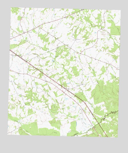
Connor, TX USGS Topographic Map
Click on map above to begin viewing in our Map Viewer.

This topographic map contains these locations and features:
Feature Name Type Latitude Longitude GNIS ID View Map
Burke-Sullivan LakeReservoirN30.9270°W95.8073°1860613View Map
Burke-Sullivan Lake DamDamN30.9269°W95.8052°1860612View Map
Burrows CemeteryCemeteryN30.9580°W95.8219°1353389View Map
Caney CreekStreamN30.8780°W95.7958°1353734View Map
Collard CreekStreamN30.8830°W95.7819°1354783View Map
ConnorPopulated PlaceN30.9649°W95.8127°1379586View Map
Farris CemeteryCemeteryN30.9277°W95.8316°1357258View Map
JenkinsPopulated PlaceN30.9752°W95.8591°1380000View Map
Joe Brown LakeLakeN30.9488°W95.8263°1360278View Map
Larrison CemeteryCemeteryN30.9938°W95.7994°1360954View Map
Little Rock ChurchChurchN30.9694°W95.8005°1361449View Map
Mill BranchStreamN30.8780°W95.7966°1374935View Map
Nixon BranchStreamN30.8980°W95.8127°1363918View Map
Park CemeteryCemeteryN30.9410°W95.8536°1364815View Map
Pooles CreekStreamN30.8927°W95.7688°1365581View Map
Rocky Hill CemeteryCemeteryN30.9391°W95.8316°1366789View Map
Sand BranchStreamN30.9535°W95.8283°1367556View Map
South Bethel SchoolSchoolN30.9702°W95.7997°1368630View Map
Springboard LakeLakeN30.9534°W95.8238°1369036View Map
Spurlock LakeReservoirN30.9116°W95.8098°1860615View Map
Spurlock Lake DamDamN30.9102°W95.8102°1860614View Map
Willow BranchStreamN30.9474°W95.8244°1371619View Map

Note: Coordinates in the location and feature list above are referenced to NAD83 datum.


Copyright (C) 2008-2024 Ryan Niemi / Sunset Dynamics ... All Rights Reserved