TopoQuest Logo
Do you find TopoQuest useful?
Help keep TopoQuest running and adding new maps/features by donating!
Bitcoin:  19c7KJd3qBynnjoSw5npx9KScwjBe4ifkT
Litecoin:  LXs6TkuXGGXo1vDsWCkWVdjQX94eUKd6ui
Home View Maps Find Maps Find Places Resources & Links


Emmet, Arkansas Topographic Map

USGS Map Title: Emmet, AR
USGS Map MRC: 33093F4
DRG (GeoTIFF) Download: o33093f4.tif


Neighboring USGS Topographic Map Quads:


  Blevins, AR  
33093G5
 

  Prescott West, AR  
33093G4
 

  Prescott East, AR  
33093G3
 

  Hope, AR  
33093F5
 

  Emmet, AR  
33093F4
 

  Laneburg, AR  
33093F3
 

  Patmos, AR  
33093E5
 

  Bodcaw, AR  
33093E4
 

  Willisville, AR  
33093E3


Map MRC Location:

N34°
W94°
N34°
W93°
H8 H7 H6 H5 H4 H3 H2 H1
G8 G7 G6 G5 G4 G3 G2 G1
F8 F7 F6 F5 F4 F3 F2 F1
E8 E7 E6 E5 E4 E3 E2 E1
D8 D7 D6 D5 D4 D3 D2 D1
C8 C7 C6 C5 C4 C3 C2 C1
B8 B7 B6 B5 B4 B3 B2 B1
A8 A7 A6 A5 A4 A3 A2 A1
N33°
W94°
N33°
W93°

Emmet, AR USGS 1:24K Topographic Map Preview:
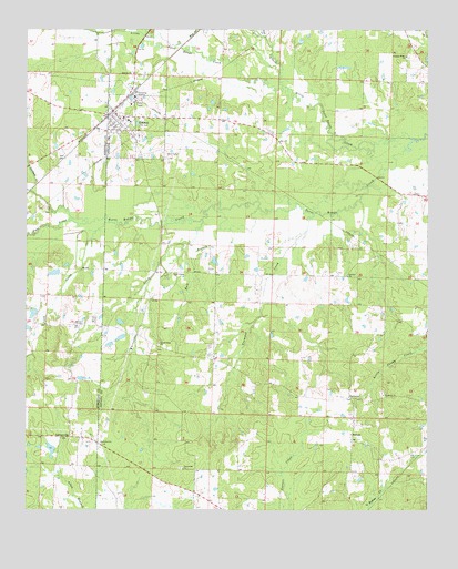
Emmet, AR USGS Topographic Map
Click on map above to begin viewing in our Map Viewer.

This topographic map contains these locations and features:
Feature Name Type Latitude Longitude GNIS ID View Map
Antioch ChurchChurchN33.6862°W93.3999°45895View Map
Antioch Church (historical)ChurchN33.7229°W93.4268°60335View Map
Antioch School (historical)SchoolN33.6854°W93.4032°60336View Map
Bull BranchStreamN33.7037°W93.4418°47166View Map
Catfish PondReservoirN33.6867°W93.4914°80725View Map
Catfish Pond DamDamN33.6868°W93.4902°80724View Map
CentervillePopulated PlaceN33.6443°W93.4893°56955View Map
City of EmmetCivilN33.7228°W93.4659°2403565View Map
Clayton (historical)Populated PlaceN33.6262°W93.4399°60469View Map
EmmetPopulated PlaceN33.7262°W93.4705°48893View Map
Emmet Elementary SchoolSchoolN33.7265°W93.4682°60352View Map
Emmet Fire StationBuildingN33.7268°W93.4704°2116404View Map
Emmet High SchoolSchoolN33.7261°W93.4678°60353View Map
Ephesus ChurchChurchN33.7387°W93.4668°48907View Map
Fairview Church (historical)ChurchN33.6357°W93.4452°60354View Map
Forest Hill ChurchChurchN33.6359°W93.4510°49167View Map
Garland CreekStreamN33.7082°W93.4993°49341View Map
HarmonyPopulated PlaceN33.6543°W93.3991°57048View Map
Harmony United Methodist ChurchChurchN33.6551°W93.3888°77122View Map
KHPA-FM (Hope)TowerN33.7196°W93.4855°85398View Map
Lick CreekStreamN33.6998°W93.4743°51141View Map
Little Terre Rouge CreekStreamN33.7218°W93.3802°51331View Map
Macedonia Church (historical)ChurchN33.6390°W93.4693°60369View Map
May CreekStreamN33.7459°W93.4485°51754View Map
New Liberty Missionary Baptist ChurchChurchN33.6865°W93.4541°77829View Map
New Liberty School (historical)SchoolN33.6754°W93.4485°60376View Map
Pate CreekStreamN33.7004°W93.4821°53212View Map
Pine CreekStreamN33.7484°W93.4263°53414View Map
Pleasant Ridge ChurchChurchN33.7432°W93.3818°53593View Map
Rocky Mound PondReservoirN33.6762°W93.4979°81010View Map
Rocky Mound Pond DamDamN33.6768°W93.4968°81009View Map
Rolling Hills PondReservoirN33.6723°W93.4997°81012View Map
Rolling Hills Pond DamDamN33.6718°W93.4985°81011View Map
Snell CemeteryCemeteryN33.7182°W93.4577°54981View Map
Steel CreekStreamN33.7354°W93.4205°55188View Map
SuttonPopulated PlaceN33.6448°W93.3985°58719View Map
Sweet Home United Methodist ChurchChurchN33.6687°W93.4585°78511View Map
Township of AlbanyCivilN33.6571°W93.3857°68898View Map
Township of EmmetCivilN33.7093°W93.4435°68901View Map
Trammel CreekStreamN33.7021°W93.4105°78574View Map
Vickers CreekStreamN33.7493°W93.4627°55904View Map
Whiteside CreekStreamN33.7009°W93.4452°56327View Map

Note: Coordinates in the location and feature list above are referenced to NAD83 datum.


Copyright (C) 2008-2024 Ryan Niemi / Sunset Dynamics ... All Rights Reserved