TopoQuest Logo
Do you find TopoQuest useful?
Help keep TopoQuest running and adding new maps/features by donating!
Bitcoin:  19c7KJd3qBynnjoSw5npx9KScwjBe4ifkT
Litecoin:  LXs6TkuXGGXo1vDsWCkWVdjQX94eUKd6ui
Home View Maps Find Maps Find Places Resources & Links


Arkdale NE, Wisconsin Topographic Map

USGS Map Title: Arkdale NE, WI
USGS Map MRC: 44089B7
DRG (GeoTIFF) Download: o44089b7.tif


Neighboring USGS Topographic Map Quads:


  Nekoosa, WI  
44089C8
 

  Wisconsin Rapids South, WI  
44089C7
 

  Kellner, WI  
44089C6
 

  Arkdale NW, WI  
44089B8
 

  Arkdale NE, WI  
44089B7
 

  Coloma NW, WI  
44089B6
 

  Arkdale, WI  
44089A8
 

  Roche A Cri, WI  
44089A7
 

  Coloma SW, WI  
44089A6


Map MRC Location:

N45°
W90°
N45°
W89°
H8 H7 H6 H5 H4 H3 H2 H1
G8 G7 G6 G5 G4 G3 G2 G1
F8 F7 F6 F5 F4 F3 F2 F1
E8 E7 E6 E5 E4 E3 E2 E1
D8 D7 D6 D5 D4 D3 D2 D1
C8 C7 C6 C5 C4 C3 C2 C1
B8 B7 B6 B5 B4 B3 B2 B1
A8 A7 A6 A5 A4 A3 A2 A1
N44°
W90°
N44°
W89°

Arkdale NE, WI USGS 1:24K Topographic Map Preview:
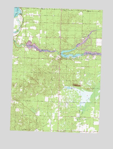
Arkdale NE, WI USGS Topographic Map
Click on map above to begin viewing in our Map Viewer.

This topographic map contains these locations and features:
Feature Name Type Latitude Longitude GNIS ID View Map
70 ReservoirReservoirN44.2100°W89.7868°1791783View Map
Altoona Lake 830ReservoirN44.2017°W89.7993°1791663View Map
Chester School (historical)SchoolN44.2361°W89.8632°1837578View Map
Devils ElbowBendN44.2430°W89.8665°1563931View Map
Dorra Cooshe MountSummitN44.1730°W89.7840°2760568View Map
Dorra Cooshe MountainSummitN44.1730°W89.7837°1876556View Map
Dorro Couche LakeLakeN44.1700°W89.7946°1564069View Map
Dorro Couche Lookout TowerTowerN44.1730°W89.7840°1581206View Map
Lake ArrowheadReservoirN44.2097°W89.8414°1793430View Map
Lake Arrowhead 3WR1493 DamDamN44.2083°W89.8585°1793429View Map
Lake Arrowhead Census Designated PlaceCensusN44.2030°W89.8389°2586515View Map
Lake Camelot 3WR324 DamDamN44.2100°W89.7868°1791782View Map
Lake Camelot Census Designated PlaceCensusN44.2147°W89.7623°2586516View Map
Lake SherwoodReservoirN44.2031°W89.7914°1574045View Map
Lake Sherwood Census Designated PlaceCensusN44.2057°W89.7941°2586519View Map
Nekoosa Lookout TowerTowerN44.2489°W89.8057°1581293View Map
New Rome (historical)Populated PlaceN44.2422°W89.8626°1837593View Map
Niebull CemeteryCemeteryN44.1266°W89.7535°1570291View Map
Niebull School (historical)SchoolN44.1266°W89.7573°1837594View Map
RomePopulated PlaceN44.2206°W89.8084°2742066View Map
Rome Police DepartmentBuildingN44.2219°W89.8093°2759797View Map
Rome Township Fire DepartmentBuildingN44.1983°W89.8688°2697797View Map
Rome Township Fire DepartmentBuildingN44.2218°W89.8093°2698016View Map
Sherwood 3WR1125 DamDamN44.2033°W89.8068°1791662View Map
Spring BranchStreamN44.2133°W89.7848°1574589View Map
Spring Branch CemeteryCemeteryN44.2219°W89.7776°1574590View Map
Town of RomeCivilN44.2014°W89.8155°1584060View Map
Zion ChurchChurchN44.1266°W89.7551°1577158View Map

Note: Coordinates in the location and feature list above are referenced to NAD83 datum.


Copyright (C) 2008-2024 Ryan Niemi / Sunset Dynamics ... All Rights Reserved