TopoQuest Logo
Do you find TopoQuest useful?
Help keep TopoQuest running and adding new maps/features by donating!
Bitcoin:  19c7KJd3qBynnjoSw5npx9KScwjBe4ifkT
Litecoin:  LXs6TkuXGGXo1vDsWCkWVdjQX94eUKd6ui
Home View Maps Find Maps Find Places Resources & Links


Roche A Cri, Wisconsin Topographic Map

USGS Map Title: Roche A Cri, WI
USGS Map MRC: 44089A7
DRG (GeoTIFF) Download: o44089a7.tif


Neighboring USGS Topographic Map Quads:


  Arkdale NW, WI  
44089B8
 

  Arkdale NE, WI  
44089B7
 

  Coloma NW, WI  
44089B6
 

  Arkdale, WI  
44089A8
 

  Roche A Cri, WI  
44089A7
 

  Coloma SW, WI  
44089A6
 

  Dellwood, WI  
43089H8
 

  Adams, WI  
43089H7
 

  Grand Marsh, WI  
43089H6


Map MRC Location:

N45°
W90°
N45°
W89°
H8 H7 H6 H5 H4 H3 H2 H1
G8 G7 G6 G5 G4 G3 G2 G1
F8 F7 F6 F5 F4 F3 F2 F1
E8 E7 E6 E5 E4 E3 E2 E1
D8 D7 D6 D5 D4 D3 D2 D1
C8 C7 C6 C5 C4 C3 C2 C1
B8 B7 B6 B5 B4 B3 B2 B1
A8 A7 A6 A5 A4 A3 A2 A1
N44°
W90°
N44°
W89°

Roche A Cri, WI USGS 1:24K Topographic Map Preview:
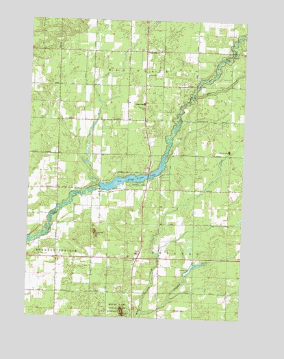
Roche A Cri, WI USGS Topographic Map
Click on map above to begin viewing in our Map Viewer.

This topographic map contains these locations and features:
Feature Name Type Latitude Longitude GNIS ID View Map
Adams County Fire District Strongs Prairie SubstationBuildingN44.0255°W89.8676°2697615View Map
Adams County Landfill, Recycling and Composting FacilityLocaleN44.0308°W89.8419°2635479View Map
Big FlatsPopulated PlaceN44.1119°W89.8079°1561723View Map
Big Flats Volunteer Fire DepartmentBuildingN44.1124°W89.7991°2697483View Map
Big Flats WP277 DamDamN44.0547°W89.8333°1791780View Map
Big Roche a Cri LakeReservoirN44.0582°W89.8155°1791781View Map
Bingham CreekStreamN44.0025°W89.8071°1561799View Map
CottonvillePopulated PlaceN44.0583°W89.8065°1837579View Map
Cottonville CemeteryCemeteryN44.0544°W89.8268°1563429View Map
Cottonville RocksSummitN44.0364°W89.8354°1563430View Map
Cottonville School (historical)SchoolN44.0500°W89.8335°1837580View Map
Dead Horse CreekStreamN44.0539°W89.8404°1563768View Map
Dry CreekStreamN44.0927°W89.7793°1564116View Map
Minnie RockSummitN44.0705°W89.7585°1569570View Map
Pine Land Elementary SchoolSchoolN44.1017°W89.8064°1571530View Map
Rabbit RockSummitN44.0902°W89.8085°1572008View Map
Roche a CriSummitN44.0027°W89.8187°1572417View Map
Roche a Cri (historical)Populated PlaceN44.0536°W89.8335°1837632View Map
Roche a Cri State ParkParkN44.0016°W89.8179°1572419View Map
Roche-A-Cri Mound State Natural AreaParkN44.0025°W89.8187°2054276View Map
Roche-A-Cri Woods State Natural AreaParkN44.0025°W89.8260°2054277View Map
Town of Big FlatsCivilN44.1120°W89.7980°1582809View Map
Town of PrestonCivilN44.0251°W89.7778°1583982View Map
Zanadu Airport (historical)AirportN44.0325°W89.8651°1581861View Map

Note: Coordinates in the location and feature list above are referenced to NAD83 datum.


Copyright (C) 2008-2025 Ryan Niemi / Sunset Dynamics ... All Rights Reserved