TopoQuest Logo
Do you find TopoQuest useful?
Help keep TopoQuest running and adding new maps/features by donating!
Bitcoin:  19c7KJd3qBynnjoSw5npx9KScwjBe4ifkT
Litecoin:  LXs6TkuXGGXo1vDsWCkWVdjQX94eUKd6ui
Home View Maps Find Maps Find Places Resources & Links


Englewood, Alabama Topographic Map

USGS Map Title: Englewood, AL
USGS Map MRC: 33087A5
DRG (GeoTIFF) Download: o33087a5.tif


Neighboring USGS Topographic Map Quads:


  Coker, AL  
33087B6
 

  Tuscaloosa, AL  
33087B5
 

  Cottondale, AL  
33087B4
 

  Fosters, AL  
33087A6
 

  Englewood, AL  
33087A5
 

  Duncanville, AL  
33087A4
 

  Moundville West, AL  
32087H6
 

  Moundville East, AL  
32087H5
 

  Payne Lake, AL  
32087H4


Map MRC Location:

N34°
W88°
N34°
W87°
H8 H7 H6 H5 H4 H3 H2 H1
G8 G7 G6 G5 G4 G3 G2 G1
F8 F7 F6 F5 F4 F3 F2 F1
E8 E7 E6 E5 E4 E3 E2 E1
D8 D7 D6 D5 D4 D3 D2 D1
C8 C7 C6 C5 C4 C3 C2 C1
B8 B7 B6 B5 B4 B3 B2 B1
A8 A7 A6 A5 A4 A3 A2 A1
N33°
W88°
N33°
W87°

Englewood, AL USGS 1:24K Topographic Map Preview:
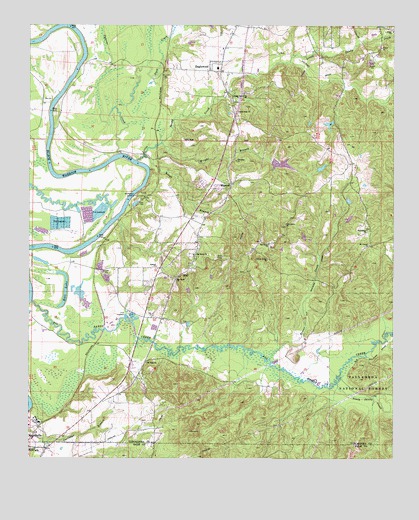
Englewood, AL USGS Topographic Map
Click on map above to begin viewing in our Map Viewer.

This topographic map contains these locations and features:
Feature Name Type Latitude Longitude GNIS ID View Map
Alabama Fire CollegeBuildingN33.1211°W87.5671°2683258View Map
Antioch Baptist ChurchChurchN33.0557°W87.5814°159071View Map
Antioch School (historical)SchoolN33.0551°W87.5811°162771View Map
Bald BarBarN33.0510°W87.6245°162772View Map
Big Sandy Baptist ChurchChurchN33.0590°W87.5683°159181View Map
Big Sandy CemeteryCemeteryN33.0582°W87.5678°158720View Map
Big Sandy CemeteryCemeteryN33.0614°W87.5425°162774View Map
Big Sandy ChurchChurchN33.0515°W87.5747°159180View Map
Big Sandy CreekStreamN33.0451°W87.6233°159183View Map
Big Sandy School (historical)SchoolN33.0587°W87.5639°162775View Map
Big Sandy United Methodist ChurchChurchN33.0621°W87.5428°159182View Map
Cain Lake Dam Number 3DamN33.0835°W87.5250°161344View Map
Cain Lake Number 1ReservoirN33.0964°W87.5221°161352View Map
Cain Lake Number 3ReservoirN33.0840°W87.5248°161345View Map
Cards Switch (historical)LocaleN33.0701°W87.5911°162777View Map
Center CemeteryCemeteryN33.0542°W87.5504°154791View Map
Cunningham BarBarN33.0690°W87.5958°162779View Map
Cunningham CreekStreamN33.0690°W87.5947°162780View Map
Cypress CreekStreamN33.0882°W87.5936°159478View Map
Duck CreekStreamN33.1018°W87.5956°159532View Map
Duncanville Volunteer Fire Department Inglewood StationBuildingN33.0780°W87.5558°2682734View Map
Eagle ShoalsBarN33.1015°W87.6181°162784View Map
Ebenezer ChurchChurchN33.0862°W87.5539°159552View Map
EnglewoodPopulated PlaceN33.1118°W87.5597°159569View Map
Englewood Baptist ChurchChurchN33.1185°W87.5586°162785View Map
Englewood Elementary SchoolSchoolN33.1126°W87.5606°162786View Map
Englewood SwampSwampN33.1035°W87.5867°162787View Map
Frank Butler Civitan ParkParkN33.1126°W87.5622°162789View Map
Friendship CemeteryCemeteryN33.0659°W87.5094°158729View Map
Friendship ChurchChurchN33.0660°W87.5089°159633View Map
Frierson (historical)LocaleN33.0598°W87.5486°162790View Map
Gilgal Baptist ChurchChurchN33.1232°W87.5003°159665View Map
Gilgal CemeteryCemeteryN33.1243°W87.5006°162791View Map
Gunn ChuteChannelN33.1151°W87.6070°162793View Map
Hintons Mill (historical)LocaleN33.0973°W87.5750°162795View Map
HullPopulated PlaceN33.0537°W87.5717°159826View Map
Hull Consolidated School (historical)SchoolN33.0576°W87.5678°162797View Map
Hull LakeLakeN33.0443°W87.6137°159827View Map
Hulls CemeteryCemeteryN33.0442°W87.5919°158734View Map
Hulls LandingLocaleN33.0593°W87.6092°162798View Map
Indian Mounds Baptist ChapelChurchN33.0023°W87.6189°154560View Map
Jack Duke LakeReservoirN33.0850°W87.5371°161346View Map
Jack Duke Lake DamDamN33.0851°W87.5383°161347View Map
Kentons Mill (historical)LocaleN33.1035°W87.5586°162799View Map
Kings (historical)LocaleN33.0757°W87.5839°162800View Map
Kings BranchStreamN33.0868°W87.5842°159898View Map
Kings MountainSummitN33.0882°W87.5795°162801View Map
Kings Mountain BarBarN33.0771°W87.5889°162802View Map
Lake Duke Dam LowerDamN33.0851°W87.5400°161349View Map
Lake Duke LowerReservoirN33.0852°W87.5406°161348View Map
Little Center ChurchChurchN33.0573°W87.5431°159960View Map
Little Center School (historical)SchoolN33.0573°W87.5428°162804View Map
Little Log ShoalsBarN33.0815°W87.6156°162805View Map
Little SandyPopulated PlaceN33.1001°W87.5550°162806View Map
Little Sandy Baptist ChurchChurchN33.1046°W87.5553°159983View Map
Little Sandy CemeteryCemeteryN33.1034°W87.5544°162807View Map
Little Sandy CreekStreamN33.0860°W87.5883°159984View Map
Little Satan Church (historical)ChurchN33.0104°W87.5389°162808View Map
Log ShoalsBarN33.0862°W87.6186°162809View Map
MaxwellPopulated PlaceN33.0793°W87.5556°160059View Map
Maxwell BendBendN33.0829°W87.5853°157822View Map
Maxwells Crossing (historical)LocaleN33.0868°W87.5808°157824View Map
McCowans BarBarN33.0154°W87.6236°157829View Map
McGowins BluffCliffN33.0143°W87.6231°157830View Map
McPherson LandingLocaleN33.0762°W87.5886°160079View Map
Mount Carmel ChurchChurchN33.0618°W87.5083°160147View Map
Mount Sinai ChurchChurchN33.0276°W87.5845°160177View Map
Mount Sinai ChurchChurchN33.0771°W87.5125°154790View Map
New Bethlehem Church (historical)ChurchN33.0751°W87.6056°162812View Map
Oak Grove CemeteryCemeteryN33.0673°W87.5372°158747View Map
Oak Grove ChurchChurchN33.0676°W87.5369°160267View Map
Oak Grove School (historical)SchoolN33.0682°W87.5375°162813View Map
Old Railroad Grade Pond DamDamN33.0968°W87.5200°161353View Map
Pheiffer LandingLocaleN33.0696°W87.5942°162816View Map
Rosser CreekStreamN33.0290°W87.5422°160538View Map
Rossers Mill (historical)LocaleN33.0501°W87.5069°162820View Map
South Sandy CreekStreamN33.0218°W87.5189°160649View Map
Tussels BarBarN33.0868°W87.5936°162828View Map
Warrior LakeLakeN33.0317°W87.5501°132737View Map
Woolseys Bluff Landing (historical)LocaleN33.0946°W87.6167°162829View Map
Wright BranchStreamN33.0910°W87.5797°160873View Map
Zion Hope ChurchChurchN33.1001°W87.5531°160877View Map

Note: Coordinates in the location and feature list above are referenced to NAD83 datum.


Copyright (C) 2008-2024 Ryan Niemi / Sunset Dynamics ... All Rights Reserved