TopoQuest Logo
Do you find TopoQuest useful?
Help keep TopoQuest running and adding new maps/features by donating!
Bitcoin:  19c7KJd3qBynnjoSw5npx9KScwjBe4ifkT
Litecoin:  LXs6TkuXGGXo1vDsWCkWVdjQX94eUKd6ui
Home View Maps Find Maps Find Places Resources & Links


Duncanville, Alabama Topographic Map

USGS Map Title: Duncanville, AL
USGS Map MRC: 33087A4
DRG (GeoTIFF) Download: o33087a4.tif


Neighboring USGS Topographic Map Quads:


  Tuscaloosa, AL  
33087B5
 

  Cottondale, AL  
33087B4
 

  Coaling, AL  
33087B3
 

  Englewood, AL  
33087A5
 

  Duncanville, AL  
33087A4
 

  Pearson, AL  
33087A3
 

  Moundville East, AL  
32087H5
 

  Payne Lake, AL  
32087H4
 

  Pondville, AL  
32087H3


Map MRC Location:

N34°
W88°
N34°
W87°
H8 H7 H6 H5 H4 H3 H2 H1
G8 G7 G6 G5 G4 G3 G2 G1
F8 F7 F6 F5 F4 F3 F2 F1
E8 E7 E6 E5 E4 E3 E2 E1
D8 D7 D6 D5 D4 D3 D2 D1
C8 C7 C6 C5 C4 C3 C2 C1
B8 B7 B6 B5 B4 B3 B2 B1
A8 A7 A6 A5 A4 A3 A2 A1
N33°
W88°
N33°
W87°

Duncanville, AL USGS 1:24K Topographic Map Preview:
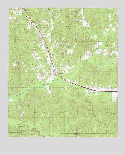
Duncanville, AL USGS Topographic Map
Click on map above to begin viewing in our Map Viewer.

This topographic map contains these locations and features:
Feature Name Type Latitude Longitude GNIS ID View Map
Allen School (historical)SchoolN33.0432°W87.4364°162770View Map
Bear CreekStreamN33.0554°W87.4425°159130View Map
Big Sandy-Duncanville DivisionCivilN33.0599°W87.4685°165971View Map
Bunch CreekStreamN33.0557°W87.4478°159271View Map
Clifton (historical)LocaleN33.0140°W87.4786°159007View Map
Counters BranchStreamN33.0640°W87.4256°159454View Map
Darden BranchStreamN33.0482°W87.4686°159486View Map
DuncanvillePopulated PlaceN33.0618°W87.4422°159538View Map
Duncanville Baptist ChurchChurchN33.0679°W87.4492°162781View Map
Duncanville CemeteryCemeteryN33.0626°W87.4422°162782View Map
Duncanville ChurchChurchN33.0762°W87.4381°154789View Map
Duncanville Post OfficePost OfficeN33.0678°W87.4478°169148View Map
Duncanville United Methodist ChurchChurchN33.0615°W87.4425°162783View Map
Duncanville Volunteer Fire Department Monticello StationBuildingN33.1158°W87.4804°2682856View Map
Duncanville Volunteer Fire Department Southfork StationBuildingN33.0900°W87.4601°2682751View Map
Evergreen School (historical)SchoolN33.0273°W87.4797°162788View Map
Flint BranchStreamN33.1001°W87.3844°159616View Map
Fosters Ferry (historical)CrossingN33.1185°W87.4958°148163View Map
Griffin (historical)LocaleN33.0093°W87.4897°162792View Map
Hewetts Mill (historical)LocaleN33.0471°W87.4714°162794View Map
Horse CreekStreamN33.0804°W87.4028°159810View Map
Howell School (historical)SchoolN33.0454°W87.3978°162796View Map
Indian CreekStreamN33.0412°W87.4881°159836View Map
Jackson Sod FarmLocaleN33.0578°W87.4461°2516194View Map
Lake Judson DamDamN33.1235°W87.4550°161357View Map
Little Indian CreekStreamN33.0632°W87.4894°159973View Map
Lye BranchStreamN33.0751°W87.4108°160011View Map
Matthews LakeReservoirN33.0876°W87.4324°160056View Map
Maxwell Elementary SchoolSchoolN33.1162°W87.4797°157823View Map
Modina (historical)LocaleN33.0562°W87.4506°157847View Map
Monticello EstatesPopulated PlaceN33.1193°W87.4750°157851View Map
Monticello TwoPopulated PlaceN33.1123°W87.4844°157852View Map
Mount Olive CemeteryCemeteryN33.0784°W87.4692°158763View Map
Mount Olive ChurchChurchN33.0782°W87.4700°160162View Map
Mount Olive School (historical)SchoolN33.0787°W87.4697°157869View Map
Mount Sinai CemeteryCemeteryN33.0296°W87.4778°157871View Map
Mount Sinai ChurchChurchN33.0296°W87.4783°160178View Map
Mount Zion Baptist ChurchChurchN33.1168°W87.4314°160187View Map
Mount Zion CemeteryCemeteryN33.1179°W87.4294°162810View Map
Pattons LakeReservoirN33.1154°W87.4257°160347View Map
Pearl (historical)LocaleN33.0840°W87.3783°162814View Map
Phalin (historical)LocaleN33.0496°W87.4167°162815View Map
Pleasant Hill Church (historical)ChurchN33.0868°W87.4036°162817View Map
Raintree CountryPopulated PlaceN33.1098°W87.4944°162819View Map
Sand MountainSummitN33.1021°W87.4786°162821View Map
Shady Grove Church (historical)ChurchN33.0260°W87.4058°162824View Map
Shiloh CemeteryCemeteryN33.0126°W87.3897°162825View Map
Shiloh Lookout TowerTowerN33.0232°W87.3783°164418View Map
Shiloh Methodist ChurchChurchN33.0135°W87.3900°160599View Map
Skyview LakeReservoirN33.1226°W87.4213°160620View Map
South Sandy CemeteryCemeteryN33.0052°W87.4866°160648View Map
South Sandy Church (historical)ChurchN33.0143°W87.4983°162826View Map
Spring Hill Church (historical)ChurchN33.0868°W87.3992°162827View Map
Steiner LakeReservoirN33.1135°W87.4210°160671View Map
Steiner Lake DamDamN33.1135°W87.4183°161354View Map
Sycamore School (historical)SchoolN33.0035°W87.4875°161958View Map
Tadpole CreekStreamN33.0601°W87.4486°160706View Map
WUAL-FM (Tuscaloosa)TowerN33.0946°W87.4131°161170View Map

Note: Coordinates in the location and feature list above are referenced to NAD83 datum.


Copyright (C) 2008-2024 Ryan Niemi / Sunset Dynamics ... All Rights Reserved