TopoQuest Logo
Do you find TopoQuest useful?
Help keep TopoQuest running and adding new maps/features by donating!
Bitcoin:  19c7KJd3qBynnjoSw5npx9KScwjBe4ifkT
Litecoin:  LXs6TkuXGGXo1vDsWCkWVdjQX94eUKd6ui
Home View Maps Find Maps Find Places Resources & Links


Fosters, Alabama Topographic Map

USGS Map Title: Fosters, AL
USGS Map MRC: 33087A6
DRG (GeoTIFF) Download: o33087a6.tif


Neighboring USGS Topographic Map Quads:


  Romulus, AL  
33087B7
 

  Coker, AL  
33087B6
 

  Tuscaloosa, AL  
33087B5
 

  Ralph, AL  
33087A7
 

  Fosters, AL  
33087A6
 

  Englewood, AL  
33087A5
 

  Knoxville, AL  
32087H7
 

  Moundville West, AL  
32087H6
 

  Moundville East, AL  
32087H5


Map MRC Location:

N34°
W88°
N34°
W87°
H8 H7 H6 H5 H4 H3 H2 H1
G8 G7 G6 G5 G4 G3 G2 G1
F8 F7 F6 F5 F4 F3 F2 F1
E8 E7 E6 E5 E4 E3 E2 E1
D8 D7 D6 D5 D4 D3 D2 D1
C8 C7 C6 C5 C4 C3 C2 C1
B8 B7 B6 B5 B4 B3 B2 B1
A8 A7 A6 A5 A4 A3 A2 A1
N33°
W88°
N33°
W87°

Fosters, AL USGS 1:24K Topographic Map Preview:
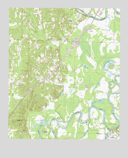
Fosters, AL USGS Topographic Map
Click on map above to begin viewing in our Map Viewer.

This topographic map contains these locations and features:
Feature Name Type Latitude Longitude GNIS ID View Map
Arthur CreekStreamN33.0951°W87.7142°113237View Map
Beale CemeteryCemeteryN33.0788°W87.6951°158719View Map
Beals BarBarN33.0173°W87.6947°147840View Map
Beals LandingLocaleN33.0260°W87.6583°147841View Map
Big Cypress Lake DamDamN33.0668°W87.6400°131187View Map
Big LakeLakeN33.0526°W87.6501°114294View Map
Big Sandy CutoffBendN33.0473°W87.6264°147877View Map
Bohannons BarBarN33.0132°W87.7145°132473View Map
Burroughs LandingLocaleN33.0265°W87.6722°147923View Map
Buzzards BarBarN33.0160°W87.6667°147925View Map
Carthage BranchStreamN33.0118°W87.6286°159333View Map
Cypress PondLakeN33.0650°W87.6373°116999View Map
Dry CreekStreamN33.0998°W87.6664°117570View Map
Dry Creek CemeteryCemeteryN33.1140°W87.6696°148067View Map
Dry Creek ChurchChurchN33.1157°W87.6697°117598View Map
Dry Creek Junior High School (historical)SchoolN33.1135°W87.6786°165405View Map
Eddins CutoffBendN33.0187°W87.6981°148092View Map
Foster CemeteryCemeteryN33.0748°W87.6959°158726View Map
Foster CemeteryCemeteryN33.0800°W87.7032°158727View Map
Foster Ferry BridgeBridgeN33.1187°W87.6620°118536View Map
Foster LandingLocaleN33.1173°W87.6397°148161View Map
FostersPopulated PlaceN33.0948°W87.6858°156372View Map
Fosters - Ralph Volunteer Fire Department Fosters StationBuildingN33.0941°W87.6910°2683423View Map
Fosters BarBarN33.0446°W87.6261°148162View Map
Fosters DivisionCivilN33.0820°W87.7272°165976View Map
Fosters Mill (historical)LocaleN33.0926°W87.7078°148164View Map
Fosters Post OfficePost OfficeN33.0950°W87.6869°169155View Map
Grant CreekStreamN33.0182°W87.6939°119238View Map
Grant Creek School (historical)SchoolN33.1096°W87.6997°148190View Map
Grants Creek Baptist ChurchChurchN33.0960°W87.7053°119239View Map
Grants Creek CemeteryCemeteryN33.0965°W87.7036°158732View Map
Hemphill BendBendN33.0157°W87.6322°119944View Map
Hiphill LandingLocaleN33.0321°W87.6556°148235View Map
Holly Springs Baptist ChurchChurchN33.1215°W87.7361°155874View Map
Holly Springs CemeteryCemeteryN33.1211°W87.7366°148241View Map
Interchange 62CrossingN33.0893°W87.6764°155713View Map
Izzard ShoalsBarN33.0040°W87.7150°138999View Map
Jones - Townsend CemeteryCemeteryN33.0557°W87.6910°158735View Map
Jones Archaeological MuseumBuildingN33.0062°W87.6350°2492250View Map
Kings Ferry (historical)CrossingN33.0601°W87.6300°148301View Map
Kings Ferry Landing (historical)LocaleN33.0598°W87.6289°148302View Map
Lake GloriaReservoirN33.0428°W87.6886°131174View Map
Lake Gloria DamDamN33.0418°W87.6883°131173View Map
Lewis BarBarN33.0312°W87.6317°148327View Map
Little Mission Baptist ChurchChurchN33.0071°W87.7325°158003View Map
Live Oak School (historical)SchoolN33.0062°W87.7456°132613View Map
Manleys LandingLocaleN33.1140°W87.6511°148354View Map
Moon LakeLakeN33.0550°W87.6349°122984View Map
Mound State MonumentParkN33.0048°W87.6331°160144View Map
Moundville State MonumentParkN33.0050°W87.6314°2492245View Map
Mount Zion African Methodist Episcopal Zion ChurchChurchN33.1129°W87.6692°129353View Map
Mount Zion Baptist ChurchChurchN33.0648°W87.6772°155890View Map
Mount Zion CemeteryCemeteryN33.0648°W87.6778°158744View Map
Mount Zion CemeteryCemeteryN33.0565°W87.7283°158745View Map
Mount Zion School (historical)SchoolN33.1151°W87.6695°148357View Map
MountainbrookPopulated PlaceN33.0982°W87.7033°1700467View Map
Mud BarBarN33.0118°W87.6847°148358View Map
Myrtlewood Elementary SchoolSchoolN33.0946°W87.6897°165488View Map
O T Princes LandingLocaleN33.0104°W87.6389°148420View Map
Parham Ridge CemeteryCemeteryN33.0517°W87.7453°154792View Map
R H Fosters LandingLocaleN33.0423°W87.6386°148471View Map
Rossers Bluff Landing (historical)LocaleN33.0118°W87.6395°148509View Map
Sharpes Ferry Landing (historical)LocaleN33.0604°W87.6306°148546View Map
Snag LakeLakeN33.0364°W87.6489°127062View Map
Snag Lake DamDamN33.0335°W87.6550°131168View Map
Stewarts Mill (historical)LocaleN33.0543°W87.7436°148601View Map
SylvanPopulated PlaceN33.0729°W87.6986°148611View Map
Sylvan CemeteryCemeteryN33.0698°W87.6995°148612View Map
Sylvan School (historical)SchoolN33.0701°W87.6992°148613View Map
Sylvan United Methodist ChurchChurchN33.0704°W87.6986°153636View Map
Thornton CreekStreamN33.0954°W87.7145°127935View Map
Touson LakeLakeN33.0069°W87.6623°153706View Map
Toxy BendBendN33.0165°W87.6658°153713View Map
Twentyone Mile BarBarN33.1201°W87.6267°148672View Map
Vancleave BarBarN33.0257°W87.6320°148700View Map
Vancleaves Landing (historical)LocaleN33.0362°W87.6361°148701View Map
Victorious Life ChurchChurchN33.0679°W87.7022°1700484View Map
Warrior Chapel (historical)ChurchN33.0418°W87.7089°148714View Map
Wells CemeteryCemeteryN33.0585°W87.7328°1700485View Map
Wiggins LakeLakeN33.0027°W87.6400°128945View Map
Wiggins Lake DamDamN33.0035°W87.6417°131141View Map
Wild Horse BarBarN33.0257°W87.6425°148747View Map
Wilford BendBendN33.0085°W87.7153°148750View Map
Willifords LandingLocaleN33.0182°W87.7125°148752View Map
Woods CreekStreamN33.0935°W87.7086°129212View Map
Zion Hill CemeteryCemeteryN33.1134°W87.6690°148776View Map
Zion School (historical)SchoolN33.0648°W87.6772°148777View Map

Note: Coordinates in the location and feature list above are referenced to NAD83 datum.


Copyright (C) 2008-2024 Ryan Niemi / Sunset Dynamics ... All Rights Reserved