TopoQuest Logo
Do you find TopoQuest useful?
Help keep TopoQuest running and adding new maps/features by donating!
Bitcoin:  19c7KJd3qBynnjoSw5npx9KScwjBe4ifkT
Litecoin:  LXs6TkuXGGXo1vDsWCkWVdjQX94eUKd6ui
Home View Maps Find Maps Find Places Resources & Links


Enoch, Utah Topographic Map

USGS Map Title: Enoch, UT
USGS Map MRC: 37113G1
DRG (GeoTIFF) Download: o37113g1.tif


Neighboring USGS Topographic Map Quads:


  Enoch NW, UT  
37113H2
 

  Enoch NE, UT  
37113H1
 

  Parowan Gap, UT  
37112H8
 

  The Three Peaks, UT  
37113G2
 

  Enoch, UT  
37113G1
 

  Summit, UT  
37112G8
 

  Cedar City NW, UT  
37113F2
 

  Cedar City, UT  
37113F1
 

  Flanigan Arch, UT  
37112F8


Map MRC Location:

N38°
W114°
N38°
W113°
H8 H7 H6 H5 H4 H3 H2 H1
G8 G7 G6 G5 G4 G3 G2 G1
F8 F7 F6 F5 F4 F3 F2 F1
E8 E7 E6 E5 E4 E3 E2 E1
D8 D7 D6 D5 D4 D3 D2 D1
C8 C7 C6 C5 C4 C3 C2 C1
B8 B7 B6 B5 B4 B3 B2 B1
A8 A7 A6 A5 A4 A3 A2 A1
N37°
W114°
N37°
W113°

Enoch, UT USGS 1:24K Topographic Map Preview:
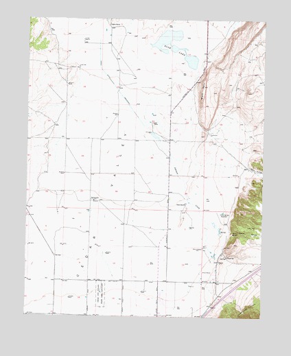
Enoch, UT USGS Topographic Map
Click on map above to begin viewing in our Map Viewer.

This topographic map contains these locations and features:
Feature Name Type Latitude Longitude GNIS ID View Map
Adams RanchLocaleN37.8722°W113.0836°1425047View Map
Bell SpringSpringN37.7751°W113.0193°1425411View Map
Black PointSummitN37.8472°W113.0327°1425700View Map
Braffits CreekStreamN37.8528°W113.0361°1425942View Map
Cedar City Upland State Game SanctuaryParkN37.7603°W113.0861°1426442View Map
Cedar ValleyValleyN37.8719°W113.0715°1426492View Map
City of EnochCivilN37.7664°W113.0431°2410444View Map
Clark Airport (historical)AirportN37.7655°W113.0841°1434552View Map
Clark RanchLocaleN37.7980°W113.0416°1426661View Map
Clarks CanyonValleyN37.7866°W113.0186°1426669View Map
Clarks SpringSpringN37.7857°W113.0137°1426670View Map
EnochPopulated PlaceN37.7733°W113.0244°1437554View Map
Enoch CemeteryCemeteryN37.7691°W113.0280°1427827View Map
Enoch City Police DepartmentBuildingN37.7644°W113.0438°2730446View Map
Enoch Elementary SchoolSchoolN37.7635°W113.0306°1435510View Map
Fort JohnsonPopulated PlaceN37.7791°W113.0322°1437562View Map
Jehovahs Witnesses Cedar City CongregationChurchN37.7569°W113.0277°1436735View Map
Johnson CreekStreamN37.8416°W113.0616°1429217View Map
Jones SpringSpringN37.7751°W113.0189°1429242View Map
KBRE-AM (Cedar City)TowerN37.7641°W113.1050°1455729View Map
Leigh FarmLocaleN37.8316°W113.0602°1429580View Map
Lone TreeLocaleN37.8550°W113.0988°1429878View Map
North Spring ReservoirReservoirN37.7941°W113.0216°1430857View Map
Rush LakeLakeN37.8634°W113.0488°1432057View Map
StevensvilleLocaleN37.7986°W113.0900°1432974View Map
The Church of Jesus Christ of Latter Day SaintsChurchN37.7653°W113.0161°1436903View Map
Valley Bible ChurchChurchN37.7544°W113.0286°1436791View Map
Winn HollowValleyN37.8133°W113.0088°1434406View Map

Note: Coordinates in the location and feature list above are referenced to NAD83 datum.


Copyright (C) 2008-2025 Ryan Niemi / Sunset Dynamics ... All Rights Reserved