TopoQuest Logo
Do you find TopoQuest useful?
Help keep TopoQuest running and adding new maps/features by donating!
Bitcoin:  19c7KJd3qBynnjoSw5npx9KScwjBe4ifkT
Litecoin:  LXs6TkuXGGXo1vDsWCkWVdjQX94eUKd6ui
Home View Maps Find Maps Find Places Resources & Links


Flanigan Arch, Utah Topographic Map

USGS Map Title: Flanigan Arch, UT
USGS Map MRC: 37112F8
DRG (GeoTIFF) Download: o37112f8.tif


Neighboring USGS Topographic Map Quads:


  Enoch, UT  
37113G1
 

  Summit, UT  
37112G8
 

  Parowan, UT  
37112G7
 

  Cedar City, UT  
37113F1
 

  Flanigan Arch, UT  
37112F8
 

  Brian Head, UT  
37112F7
 

  Cedar Mountain, UT  
37113E1
 

  Webster Flat, UT  
37112E8
 

  Navajo Lake, UT  
37112E7


Map MRC Location:

N38°
W113°
N38°
W112°
H8 H7 H6 H5 H4 H3 H2 H1
G8 G7 G6 G5 G4 G3 G2 G1
F8 F7 F6 F5 F4 F3 F2 F1
E8 E7 E6 E5 E4 E3 E2 E1
D8 D7 D6 D5 D4 D3 D2 D1
C8 C7 C6 C5 C4 C3 C2 C1
B8 B7 B6 B5 B4 B3 B2 B1
A8 A7 A6 A5 A4 A3 A2 A1
N37°
W113°
N37°
W112°

Flanigan Arch, UT USGS 1:24K Topographic Map Preview:
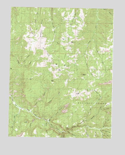
Flanigan Arch, UT USGS Topographic Map
Click on map above to begin viewing in our Map Viewer.

This topographic map contains these locations and features:
Feature Name Type Latitude Longitude GNIS ID View Map
Ashdoen Gorge WildernessReserveN37.6375°W112.8816°1450052View Map
Ashdown CreekStreamN37.6300°W112.9358°1438281View Map
Ashdown Gorge WildernessReserveN37.6412°W112.8830°2035042View Map
Avavick KnollSummitN37.7119°W112.9647°1448097View Map
Big HillSummitN37.6889°W112.9966°1438675View Map
Bluebell SpringSpringN37.6797°W112.9497°1438970View Map
Brown CreekStreamN37.7214°W112.9011°1439161View Map
Calf HollowValleyN37.6333°W112.8961°1439428View Map
Cedar MountainSummitN37.6394°W112.9766°1448249View Map
Cluff MineMineN37.6347°W112.9491°1439822View Map
Crow CreekStreamN37.6303°W112.9361°1440171View Map
Dairy HillSummitN37.7150°W112.9791°1440232View Map
Deep CanyonValleyN37.7178°W112.9469°1440338View Map
Den HollowValleyN37.6305°W112.8869°1440409View Map
Eagle PeakSummitN37.6958°W112.9455°1440761View Map
Eagle SpringSpringN37.6903°W112.9411°1440762View Map
Ellies CanyonValleyN37.6444°W112.9663°1440918View Map
First LakeLakeN37.6947°W112.9323°1441053View Map
Flanigan ArchArchN37.6341°W112.9272°1448408View Map
Grouse SpringSpringN37.7169°W112.9233°1441516View Map
Hells CanyonValleyN37.6944°W112.9877°1441687View Map
High MountainSummitN37.6697°W112.9136°1441756View Map
Jones HillSummitN37.6808°W112.9769°1442209View Map
Lake CreekStreamN37.6411°W112.9169°1442401View Map
Last Chance CanyonValleyN37.6422°W112.9524°1442449View Map
Long HollowValleyN37.6311°W112.9283°1442918View Map
MacFarlane MineMineN37.6325°W112.9427°1443056View Map
Maple CanyonValleyN37.6494°W112.9744°1443146View Map
Maple Canyon CreekStreamN37.6491°W112.9752°1451295View Map
Martins FlatFlatN37.6414°W112.9513°1443210View Map
Middle RidgeRidgeN37.7361°W112.9613°1443376View Map
Pickering CreekStreamN37.6597°W112.9599°1444336View Map
Potato HollowValleyN37.6358°W112.9072°1444605View Map
Rattlesnake CreekStreamN37.6350°W112.9174°1444737View Map
Rattlesnake Creek TrailTrailN37.6597°W112.8763°1448897View Map
Red CreekStreamN37.7061°W112.9108°1444786View Map
Right Hand CreekStreamN37.6525°W112.9874°1444970View Map
Shooting Star CreekStreamN37.6333°W112.8911°1445550View Map
Spring CreekStreamN37.6350°W112.8849°1446009View Map
Stud FlatFlatN37.6580°W112.8802°1446202View Map
Sugarloaf MountainSummitN37.6864°W112.9119°1446215View Map
Summit MountainSummitN37.7083°W112.9294°1446241View Map
Third House FlatFlatN37.7128°W112.8783°1446525View Map
Tinks RacetrackLocaleN37.6686°W112.9097°1446617View Map
Toms LakeLakeN37.7198°W112.9341°1446644View Map
Tri Story CanyonValleyN37.6528°W112.8911°1446711View Map
Webb CanyonValleyN37.7497°W112.8894°1447084View Map
Whiskey HollowValleyN37.6255°W112.9536°1447229View Map
Windy RidgeRidgeN37.7053°W112.9558°1447472View Map

Note: Coordinates in the location and feature list above are referenced to NAD83 datum.


Copyright (C) 2008-2024 Ryan Niemi / Sunset Dynamics ... All Rights Reserved