TopoQuest Logo
Do you find TopoQuest useful?
Help keep TopoQuest running and adding new maps/features by donating!
Bitcoin:  19c7KJd3qBynnjoSw5npx9KScwjBe4ifkT
Litecoin:  LXs6TkuXGGXo1vDsWCkWVdjQX94eUKd6ui
Home View Maps Find Maps Find Places Resources & Links


Cedar City NW, Utah Topographic Map

USGS Map Title: Cedar City NW, UT
USGS Map MRC: 37113F2
DRG (GeoTIFF) Download: o37113f2.tif


Neighboring USGS Topographic Map Quads:


  Avon SE, UT  
37113G3
 

  The Three Peaks, UT  
37113G2
 

  Enoch, UT  
37113G1
 

  Desert Mound, UT  
37113F3
 

  Cedar City NW, UT  
37113F2
 

  Cedar City, UT  
37113F1
 

  Stoddard Mountain, UT  
37113E3
 

  Kanarraville, UT  
37113E2
 

  Cedar Mountain, UT  
37113E1


Map MRC Location:

N38°
W114°
N38°
W113°
H8 H7 H6 H5 H4 H3 H2 H1
G8 G7 G6 G5 G4 G3 G2 G1
F8 F7 F6 F5 F4 F3 F2 F1
E8 E7 E6 E5 E4 E3 E2 E1
D8 D7 D6 D5 D4 D3 D2 D1
C8 C7 C6 C5 C4 C3 C2 C1
B8 B7 B6 B5 B4 B3 B2 B1
A8 A7 A6 A5 A4 A3 A2 A1
N37°
W114°
N37°
W113°

Cedar City NW, UT USGS 1:24K Topographic Map Preview:
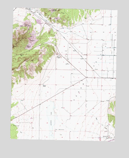
Cedar City NW, UT USGS Topographic Map
Click on map above to begin viewing in our Map Viewer.

This topographic map contains these locations and features:
Feature Name Type Latitude Longitude GNIS ID View Map
Armstrong MineMineN37.7136°W113.2322°1425169View Map
Bauers KnollSummitN37.7039°W113.1927°1425328View Map
Citabriair AirportAirportN37.6339°W113.2402°2443199View Map
Duncan CreekStreamN37.6283°W113.2286°1440716View Map
East Pioche MineMineN37.7328°W113.2333°1427716View Map
Eightmile HillsSummitN37.6997°W113.2344°1427760View Map
Eightmile PassGapN37.7053°W113.2422°1427761View Map
Eightmile SpringsSpringN37.6774°W113.2131°1427767View Map
Granite MountainSummitN37.7208°W113.2402°1428321View Map
Great Western MineMineN37.7483°W113.2041°1428385View Map
HalivahPopulated PlaceN37.7105°W113.1750°1437578View Map
Iron SpringsPopulated PlaceN37.7497°W113.2347°1437596View Map
KSUB-AM (Cedar City)TowerN37.6986°W113.1797°1455728View Map
Lindsay Hill MineMineN37.7175°W113.2288°1429646View Map
Quichapa LakeLakeN37.6372°W113.2024°1431528View Map
Shirts CreekStreamN37.6458°W113.1952°1455909View Map
Smith MineMineN37.7408°W113.1977°1432570View Map
The BottomsFlatN37.6350°W113.1941°1433276View Map
Vermillion MineMineN37.7333°W113.2394°1433883View Map
West Pioche MineMineN37.7328°W113.2344°1434106View Map

Note: Coordinates in the location and feature list above are referenced to NAD83 datum.


Copyright (C) 2008-2025 Ryan Niemi / Sunset Dynamics ... All Rights Reserved