TopoQuest Logo
Do you find TopoQuest useful?
Help keep TopoQuest running and adding new maps/features by donating!
Bitcoin:  19c7KJd3qBynnjoSw5npx9KScwjBe4ifkT
Litecoin:  LXs6TkuXGGXo1vDsWCkWVdjQX94eUKd6ui
Home View Maps Find Maps Find Places Resources & Links


Enterprise, Utah Topographic Map

USGS Map Title: Enterprise, UT
USGS Map MRC: 37113E6
DRG (GeoTIFF) Download: o37113e6.tif


Neighboring USGS Topographic Map Quads:


  Pinon Point, UT  
37113F7
 

  Beryl Junction, UT  
37113F6
 

  Newcastle, UT  
37113F5
 

  Hebron, UT  
37113E7
 

  Enterprise, UT  
37113E6
 

  Pinto, UT  
37113E5
 

  Maple Ridge, UT  
37113D7
 

  Central West, UT  
37113D6
 

  Central East, UT  
37113D5


Map MRC Location:

N38°
W114°
N38°
W113°
H8 H7 H6 H5 H4 H3 H2 H1
G8 G7 G6 G5 G4 G3 G2 G1
F8 F7 F6 F5 F4 F3 F2 F1
E8 E7 E6 E5 E4 E3 E2 E1
D8 D7 D6 D5 D4 D3 D2 D1
C8 C7 C6 C5 C4 C3 C2 C1
B8 B7 B6 B5 B4 B3 B2 B1
A8 A7 A6 A5 A4 A3 A2 A1
N37°
W114°
N37°
W113°

Enterprise, UT USGS 1:24K Topographic Map Preview:
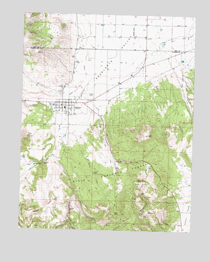
Enterprise, UT USGS Topographic Map
Click on map above to begin viewing in our Map Viewer.

This topographic map contains these locations and features:
Feature Name Type Latitude Longitude GNIS ID View Map
Big MountainSummitN37.5108°W113.6572°1438705View Map
Big Mountain Electronic SiteLocaleN37.5066°W113.6608°1449980View Map
Black CanyonValleyN37.5380°W113.7386°1438835View Map
Bullrush CreekStreamN37.5078°W113.7158°1439313View Map
Bullrush SpringSpringN37.5118°W113.7145°1439316View Map
Calf Springs CreekStreamN37.5436°W113.7277°1439430View Map
City of EnterpriseCivilN37.5716°W113.7431°2410446View Map
Cliff SpringSpringN37.5290°W113.6652°1439814View Map
Cottonwood SpringSpringN37.5404°W113.6768°1440037View Map
Cottonwood WashValleyN37.5800°W113.7122°1440044View Map
EnterprisePopulated PlaceN37.5736°W113.7191°1440940View Map
Enterprise Administrative SiteLocaleN37.5591°W113.7211°1449979View Map
Enterprise City CemeteryCemeteryN37.5761°W113.7091°1448379View Map
Enterprise Elementary SchoolSchoolN37.5700°W113.7198°1448381View Map
Enterprise High SchoolSchoolN37.5648°W113.7156°1448380View Map
Enterprise Police DepartmentBuildingN37.5674°W113.7163°2730442View Map
Enterprise Post OfficePost OfficeN37.5739°W113.7218°1455261View Map
Enterprise Volunteer Fire DepartmentBuildingN37.5699°W113.7159°2627168View Map
Enterprise Work CenterLocaleN37.5703°W113.7136°1454566View Map
Gary and Joyce Holt ReservoirReservoirN37.5375°W113.7407°1447629View Map
Gary and Joyce Holt Reservoir DamDamN37.5378°W113.7397°1447630View Map
Gum HillSummitN37.5550°W113.6583°1441527View Map
Holt CanyonValleyN37.5930°W113.6355°1441822View Map
Holt CemeteryCemeteryN37.5850°W113.6355°1441823View Map
Holt Historical SiteLocaleN37.5783°W113.6333°1451262View Map
Mud SpringSpringN37.5190°W113.6689°1443682View Map
Pendleton SpringSpringN37.5389°W113.7339°1444280View Map
Rose SpringSpringN37.5361°W113.6812°1445141View Map
Shinbone CreekStreamN37.5208°W113.7108°1445526View Map
Spring CreekStreamN37.5761°W113.7280°1446008View Map
The Church of Jesus Christ of Latter Day SaintsChurchN37.5722°W113.7219°1455636View Map
Tom SpringSpringN37.5049°W113.7161°1446638View Map
Twin SpringSpringN37.5100°W113.6814°1446807View Map
Twin Spring CreekStreamN37.5550°W113.7222°1446809View Map
Willow SpringSpringN37.5327°W113.6975°1447429View Map
Winsor Memorial CemeteryCemeteryN37.5822°W113.7219°1447485View Map

Note: Coordinates in the location and feature list above are referenced to NAD83 datum.


Copyright (C) 2008-2025 Ryan Niemi / Sunset Dynamics ... All Rights Reserved