TopoQuest Logo
Do you find TopoQuest useful?
Help keep TopoQuest running and adding new maps/features by donating!
Bitcoin:  19c7KJd3qBynnjoSw5npx9KScwjBe4ifkT
Litecoin:  LXs6TkuXGGXo1vDsWCkWVdjQX94eUKd6ui
Home View Maps Find Maps Find Places Resources & Links


Central West, Utah Topographic Map

USGS Map Title: Central West, UT
USGS Map MRC: 37113D6
DRG (GeoTIFF) Download: o37113d6.tif


Neighboring USGS Topographic Map Quads:


  Hebron, UT  
37113E7
 

  Enterprise, UT  
37113E6
 

  Pinto, UT  
37113E5
 

  Maple Ridge, UT  
37113D7
 

  Central West, UT  
37113D6
 

  Central East, UT  
37113D5
 

  Gunlock, UT  
37113C7
 

  Veyo, UT  
37113C6
 

  Saddle Mountain, UT  
37113C5


Map MRC Location:

N38°
W114°
N38°
W113°
H8 H7 H6 H5 H4 H3 H2 H1
G8 G7 G6 G5 G4 G3 G2 G1
F8 F7 F6 F5 F4 F3 F2 F1
E8 E7 E6 E5 E4 E3 E2 E1
D8 D7 D6 D5 D4 D3 D2 D1
C8 C7 C6 C5 C4 C3 C2 C1
B8 B7 B6 B5 B4 B3 B2 B1
A8 A7 A6 A5 A4 A3 A2 A1
N37°
W114°
N37°
W113°

Central West, UT USGS 1:24K Topographic Map Preview:
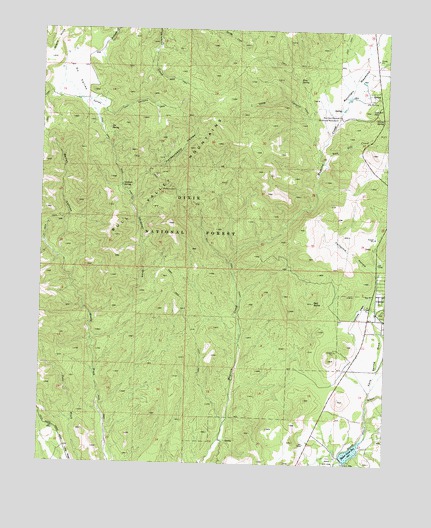
Central West, UT USGS Topographic Map
Click on map above to begin viewing in our Map Viewer.

This topographic map contains these locations and features:
Feature Name Type Latitude Longitude GNIS ID View Map
Abe SpringSpringN37.4795°W113.6291°1438114View Map
Baker ReservoirReservoirN37.3786°W113.6379°1447623View Map
Baker Reservoir DamDamN37.3769°W113.6411°1447624View Map
Baker Reservoir Recreation AreaParkN37.3761°W113.6383°1451179View Map
Baker Reservoir Recreation Area CampgroundLocaleN37.3761°W113.6383°1451180View Map
Bellas CanyonValleyN37.4350°W113.7436°1438582View Map
Blue SpringSpringN37.4857°W113.6579°1438952View Map
California HollowValleyN37.4325°W113.6316°1439433View Map
Central CemeteryCemeteryN37.4234°W113.6253°2769303View Map
Central Census Designated PlaceCensusN37.4150°W113.6263°2629947View Map
Central Fire Statiion - Northwestern Special Service Fire DistrictBuildingN37.4172°W113.6287°2768442View Map
Dan Sill CreekStreamN37.4619°W113.6483°1440247View Map
Dan Sill HillSummitN37.4772°W113.6316°1440248View Map
Deep CanyonValleyN37.4653°W113.6505°1440337View Map
Dixie Deer Airport (historical)AirportN37.4189°W113.6347°1447587View Map
Gardner DrawValleyN37.4108°W113.7316°1441270View Map
Gardner SpringSpringN37.4554°W113.7215°1441273View Map
Hardscrabble HollowValleyN37.4516°W113.7180°1441588View Map
Hardscramble SpringSpringN37.4655°W113.6952°1451258View Map
Hiway SpringSpringN37.4749°W113.6272°1441782View Map
Joe SpringSpringN37.4714°W113.7263°1442159View Map
Kane Spring DrawValleyN37.3950°W113.6313°1442276View Map
Maple SpringSpringN37.4852°W113.6714°1451298View Map
Mountain MeadowParkN37.4755°W113.6436°1443644View Map
Mountain Meadows Massacre MemorialCemeteryN37.4755°W113.6437°2769308View Map
Mud SpringSpringN37.4904°W113.6758°1455839View Map
Ox ValleyBasinN37.4858°W113.7386°1444140View Map
Red Bank SpringSpringN37.4854°W113.6820°1449967View Map
Red ButteSummitN37.4216°W113.6519°1444763View Map
Red Hardscrabble TrailTrailN37.4541°W113.7025°1449968View Map
Shinbone TrailTrailN37.4891°W113.7097°1450047View Map
Valley CanyonValleyN37.4764°W113.7277°1446906View Map

Note: Coordinates in the location and feature list above are referenced to NAD83 datum.


Copyright (C) 2008-2025 Ryan Niemi / Sunset Dynamics ... All Rights Reserved