TopoQuest Logo
Do you find TopoQuest useful?
Help keep TopoQuest running and adding new maps/features by donating!
Bitcoin:  19c7KJd3qBynnjoSw5npx9KScwjBe4ifkT
Litecoin:  LXs6TkuXGGXo1vDsWCkWVdjQX94eUKd6ui
Home View Maps Find Maps Find Places Resources & Links


Central East, Utah Topographic Map

USGS Map Title: Central East, UT
USGS Map MRC: 37113D5
DRG (GeoTIFF) Download: o37113d5.tif


Neighboring USGS Topographic Map Quads:


  Enterprise, UT  
37113E6
 

  Pinto, UT  
37113E5
 

  Page Ranch, UT  
37113E4
 

  Central West, UT  
37113D6
 

  Central East, UT  
37113D5
 

  Grass Valley, UT  
37113D4
 

  Veyo, UT  
37113C6
 

  Saddle Mountain, UT  
37113C5
 

  Signal Peak, UT  
37113C4


Map MRC Location:

N38°
W114°
N38°
W113°
H8 H7 H6 H5 H4 H3 H2 H1
G8 G7 G6 G5 G4 G3 G2 G1
F8 F7 F6 F5 F4 F3 F2 F1
E8 E7 E6 E5 E4 E3 E2 E1
D8 D7 D6 D5 D4 D3 D2 D1
C8 C7 C6 C5 C4 C3 C2 C1
B8 B7 B6 B5 B4 B3 B2 B1
A8 A7 A6 A5 A4 A3 A2 A1
N37°
W114°
N37°
W113°

Central East, UT USGS 1:24K Topographic Map Preview:
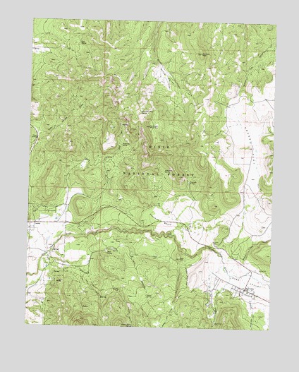
Central East, UT USGS Topographic Map
Click on map above to begin viewing in our Map Viewer.

This topographic map contains these locations and features:
Feature Name Type Latitude Longitude GNIS ID View Map
Atchinson MountainSummitN37.4566°W113.5647°1438298View Map
Atchinson SpringSpringN37.4388°W113.5563°1438299View Map
Cedar KnollSummitN37.4030°W113.5477°1439576View Map
Cedar Knoll CanyonValleyN37.4047°W113.5447°1439578View Map
CentralPopulated PlaceN37.4166°W113.6244°1439624View Map
Earl CanyonValleyN37.4119°W113.5622°1440763View Map
Earl SpringSpringN37.3755°W113.5450°1451235View Map
Eightmile SpringSpringN37.4494°W113.5784°1440874View Map
Enterprise DivisionCivilN37.4521°W113.6138°1939364View Map
Forsyth CreekStreamN37.3964°W113.5161°1441181View Map
Four Mile Bench Sewage LagoonSwampN37.4200°W113.5600°1449971View Map
Fourmile BenchBenchN37.4178°W113.5525°1441189View Map
Fourmile SpringSpringN37.4344°W113.5434°1441196View Map
Grass ValleyValleyN37.4019°W113.5147°1441431View Map
Grass Valley CreekStreamN37.3978°W113.5227°1441433View Map
Grassy FlatFlatN37.4489°W113.5133°1441441View Map
Harrison PeakSummitN37.4869°W113.5388°1441616View Map
Horse ValleyBasinN37.4778°W113.5561°1441899View Map
Indian HollowValleyN37.3847°W113.5747°1442006View Map
Indian Hollow SpringSpringN37.3756°W113.5710°1442012View Map
Indian SpringSpringN37.3878°W113.5642°1442020View Map
Kane SpringSpringN37.4519°W113.6222°1442273View Map
Lark CanyonValleyN37.4153°W113.5816°1442439View Map
Lloyd CreekStreamN37.3966°W113.5216°1442821View Map
Mahogany CreekStreamN37.4022°W113.6186°1443083View Map
Mountain Home SpringSpringN37.4628°W113.5690°1443641View Map
Mud SpringSpringN37.4051°W113.5847°1443681View Map
Nervine SpringSpringN37.3871°W113.5872°1451310View Map
Oak SpringSpringN37.4907°W113.6008°1444031View Map
Pine ValleyPopulated PlaceN37.3911°W113.5141°1444412View Map
Pine ValleyValleyN37.4061°W113.5375°1444413View Map
Pine Valley CemeteryCemeteryN37.3991°W113.5083°1448838View Map
Pine Valley Census Designated PlaceCensusN37.3904°W113.5060°2629953View Map
Pine Valley Church Historical SiteLocaleN37.4183°W113.5447°1448852View Map
Pine Valley Fire DepartmentBuildingN37.3869°W113.5021°2627297View Map
Pine Valley Post Office (historical)Post OfficeN37.3911°W113.5141°2027181View Map
Pine Valley Work CenterLocaleN37.3903°W113.5125°1454575View Map

Note: Coordinates in the location and feature list above are referenced to NAD83 datum.


Copyright (C) 2008-2025 Ryan Niemi / Sunset Dynamics ... All Rights Reserved