TopoQuest Logo
Do you find TopoQuest useful?
Help keep TopoQuest running and adding new maps/features by donating!
Bitcoin:  19c7KJd3qBynnjoSw5npx9KScwjBe4ifkT
Litecoin:  LXs6TkuXGGXo1vDsWCkWVdjQX94eUKd6ui
Home View Maps Find Maps Find Places Resources & Links


Equality, Illinois Topographic Map

USGS Map Title: Equality, IL
USGS Map MRC: 37088F3
DRG (GeoTIFF) Download: o37088f3.tif


Neighboring USGS Topographic Map Quads:


  Eldorado, IL  
37088G4
 

  Ridgway, IL  
37088G3
 

  New Haven SW, IL  
37088G2
 

  Rudement, IL  
37088F4
 

  Equality, IL  
37088F3
 

  Shawneetown, IL  
37088F2
 

  Herod, IL  
37088E4
 

  Karbers Ridge, IL  
37088E3
 

  Saline Mines, IL  
37088E2


Map MRC Location:

N38°
W89°
N38°
W88°
H8 H7 H6 H5 H4 H3 H2 H1
G8 G7 G6 G5 G4 G3 G2 G1
F8 F7 F6 F5 F4 F3 F2 F1
E8 E7 E6 E5 E4 E3 E2 E1
D8 D7 D6 D5 D4 D3 D2 D1
C8 C7 C6 C5 C4 C3 C2 C1
B8 B7 B6 B5 B4 B3 B2 B1
A8 A7 A6 A5 A4 A3 A2 A1
N37°
W89°
N37°
W88°

Equality, IL USGS 1:24K Topographic Map Preview:
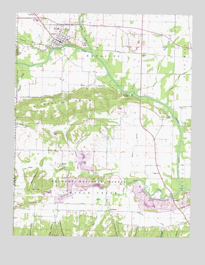
Equality, IL USGS Topographic Map
Click on map above to begin viewing in our Map Viewer.

This topographic map contains these locations and features:
Feature Name Type Latitude Longitude GNIS ID View Map
Barnett CemeteryCemeteryN37.6481°W88.3395°403912View Map
Berkel MineMineN37.6828°W88.3473°404213View Map
Black BranchStreamN37.6609°W88.3012°404481View Map
Burnt Shanty HollowValleyN37.6619°W88.3560°405256View Map
Captain Vinyard HollowValleyN37.6334°W88.3424°424712View Map
Cedar Bluff School (historical)SchoolN37.6256°W88.2909°1810992View Map
Central School (historical)SchoolN37.6481°W88.3742°1810993View Map
Clayton HollowValleyN37.6313°W88.2871°424750View Map
Cockerel BranchStreamN37.7278°W88.3587°406318View Map
Colbert HollowValleyN37.6373°W88.3628°424765View Map
Dorsey School (historical)SchoolN37.7000°W88.2989°1810994View Map
Eagle CreekStreamN37.6528°W88.2553°424850View Map
Eagle Ripple FordCrossingN37.6528°W88.2534°1810995View Map
Elmwood CemeteryCemeteryN37.7498°W88.3628°407956View Map
EqualityPopulated PlaceN37.7339°W88.3434°408051View Map
Equality Post OfficePost OfficeN37.7342°W88.3435°2788744View Map
Equality Village CemeteryCemeteryN37.7375°W88.3436°1820838View Map
Equality Volunteer Fire DepartmentBuildingN37.7338°W88.3420°2681794View Map
GibsoniaPopulated PlaceN37.6470°W88.2625°408991View Map
Greer School (historical)SchoolN37.6653°W88.3187°1810997View Map
Hickory Hill Catholic CemeteryCemeteryN37.7350°W88.2878°411855View Map
Hickory Hill ChurchChurchN37.7353°W88.2884°410166View Map
Hickory Hill School (historical)SchoolN37.7353°W88.2887°1810999View Map
Horseshoe CreekStreamN37.7212°W88.3725°410565View Map
Hutt CreekStreamN37.6448°W88.3125°425024View Map
Island Ripple Bridge (historical)BridgeN37.6973°W88.2659°1811000View Map
KedronPopulated PlaceN37.6656°W88.3414°422859View Map
LawlerPopulated PlaceN37.7281°W88.2859°422900View Map
Lawler DitchCanalN37.7167°W88.2750°411857View Map
LeamingtonPopulated PlaceN37.6395°W88.3070°422904View Map
Leamington CemeteryCemeteryN37.6389°W88.3070°1820770View Map
Level Hill CemeteryCemeteryN37.6928°W88.2673°411958View Map
Little Eagle CreekStreamN37.6553°W88.2953°425114View Map
Lloyd CemeteryCemeteryN37.6731°W88.3481°412730View Map
Maher HillSummitN37.6506°W88.3598°412849View Map
Negro Spring Salt WellWellN37.7050°W88.2948°414342View Map
North Fork Saline RiverStreamN37.7284°W88.3214°414605View Map
Olive School (historical)SchoolN37.7028°W88.3556°1811003View Map
Pisgah ChurchChurchN37.6612°W88.2725°415739View Map
Pisgah School (historical)SchoolN37.6623°W88.2817°1811004View Map
Poplar HollowValleyN37.6766°W88.3324°416034View Map
Pounds HollowValleyN37.6302°W88.2686°425351View Map
Rice HollowValleyN37.6331°W88.3458°425373View Map
Robinette CreekStreamN37.6489°W88.2973°425392View Map
Sugarcamp BranchStreamN37.6612°W88.3012°419323View Map
Thacker HollowValleyN37.6344°W88.2985°425552View Map
Township of Eagle CreekCivilN37.6434°W88.3190°428925View Map
Township of EqualityCivilN37.7321°W88.3181°428975View Map
Village of EqualityCivilN37.7371°W88.3421°2398838View Map
Wildcat HillsRangeN37.7014°W88.3359°421152View Map

Note: Coordinates in the location and feature list above are referenced to NAD83 datum.


Copyright (C) 2008-2024 Ryan Niemi / Sunset Dynamics ... All Rights Reserved