TopoQuest Logo
Do you find TopoQuest useful?
Help keep TopoQuest running and adding new maps/features by donating!
Bitcoin:  19c7KJd3qBynnjoSw5npx9KScwjBe4ifkT
Litecoin:  LXs6TkuXGGXo1vDsWCkWVdjQX94eUKd6ui
Home View Maps Find Maps Find Places Resources & Links


Erect, North Carolina Topographic Map

USGS Map Title: Erect, NC
USGS Map MRC: 35079E6
DRG (GeoTIFF) Download: o35079e6.tif


Neighboring USGS Topographic Map Quads:


  Asheboro, NC  
35079F7
 

  Ramseur, NC  
35079F6
 

  Coleridge, NC  
35079F5
 

  Seagrove, NC  
35079E7
 

  Erect, NC  
35079E6
 

  Bennett, NC  
35079E5
 

  Star, NC  
35079D7
 

  Spies, NC  
35079D6
 

  Robbins, NC  
35079D5


Map MRC Location:

N36°
W80°
N36°
W79°
H8 H7 H6 H5 H4 H3 H2 H1
G8 G7 G6 G5 G4 G3 G2 G1
F8 F7 F6 F5 F4 F3 F2 F1
E8 E7 E6 E5 E4 E3 E2 E1
D8 D7 D6 D5 D4 D3 D2 D1
C8 C7 C6 C5 C4 C3 C2 C1
B8 B7 B6 B5 B4 B3 B2 B1
A8 A7 A6 A5 A4 A3 A2 A1
N35°
W80°
N35°
W79°

Erect, NC USGS 1:24K Topographic Map Preview:
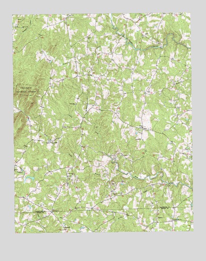
Erect, NC USGS Topographic Map
Click on map above to begin viewing in our Map Viewer.

This topographic map contains these locations and features:
Feature Name Type Latitude Longitude GNIS ID View Map
Antioch ChurchChurchN35.5843°W79.6359°1008750View Map
Bachelor CreekStreamN35.6099°W79.6698°1008828View Map
Brower SchoolSchoolN35.5599°W79.6595°1009641View Map
Coleridge Fire Department Station 10BuildingN35.5585°W79.6596°2638726View Map
Community ChurchChurchN35.5210°W79.6792°1018007View Map
ErectLocaleN35.5588°W79.6592°1011101View Map
Goss LakeReservoirN35.6185°W79.6948°1017252View Map
Goss Lake DamDamN35.6185°W79.6948°1017253View Map
JugtownPopulated PlaceN35.5082°W79.6500°1020998View Map
Lambert CreekStreamN35.5457°W79.7198°1012669View Map
Lambert Mill DamReservoirN35.5317°W79.7377°1017221View Map
Lambert Mill DamDamN35.5318°W79.7364°1017222View Map
Little CreekStreamN35.5443°W79.6850°1012939View Map
Meadow BranchStreamN35.5324°W79.6675°1013451View Map
Mount Olivet ChurchChurchN35.5529°W79.6606°1013758View Map
Needhams Grove ChurchChurchN35.5068°W79.6392°1013895View Map
New Center ChurchChurchN35.5340°W79.7078°1013916View Map
Panther Creek ChurchChurchN35.6176°W79.7428°1014213View Map
Piney Ridge ChurchChurchN35.5899°W79.6939°1014459View Map
Pleasant Hill ChurchChurchN35.5735°W79.7064°1014524View Map
Pond MountainSummitN35.5846°W79.7478°1022028View Map
Redeem ChurchChurchN35.6112°W79.6973°1014794View Map
Reedy CreekStreamN35.5274°W79.6423°1024253View Map
Richardson CreekStreamN35.5618°W79.6945°1014867View Map
Shiloh ChurchChurchN35.6129°W79.6561°1015433View Map
Township of BrowerCivilN35.5585°W79.6398°1027076View Map
Township of RichlandCivilN35.5605°W79.7473°1027090View Map
Trinity ChurchChurchN35.5438°W79.6734°1016229View Map
Union Grove ChurchChurchN35.5129°W79.7236°1016320View Map
Union Grove ChurchChurchN35.6240°W79.7103°1016321View Map
WestmorePopulated PlaceN35.5021°W79.7148°1016558View Map
Yow MillPopulated PlaceN35.5524°W79.7225°1023352View Map

Note: Coordinates in the location and feature list above are referenced to NAD83 datum.


Copyright (C) 2008-2025 Ryan Niemi / Sunset Dynamics ... All Rights Reserved