TopoQuest Logo
Do you find TopoQuest useful?
Help keep TopoQuest running and adding new maps/features by donating!
Bitcoin:  19c7KJd3qBynnjoSw5npx9KScwjBe4ifkT
Litecoin:  LXs6TkuXGGXo1vDsWCkWVdjQX94eUKd6ui
Home View Maps Find Maps Find Places Resources & Links


Ramseur, North Carolina Topographic Map

USGS Map Title: Ramseur, NC
USGS Map MRC: 35079F6
DRG (GeoTIFF) Download: o35079f6.tif


Neighboring USGS Topographic Map Quads:


  Randleman, NC  
35079G7
 

  Grays Chapel, NC  
35079G6
 

  Liberty, NC  
35079G5
 

  Asheboro, NC  
35079F7
 

  Ramseur, NC  
35079F6
 

  Coleridge, NC  
35079F5
 

  Seagrove, NC  
35079E7
 

  Erect, NC  
35079E6
 

  Bennett, NC  
35079E5


Map MRC Location:

N36°
W80°
N36°
W79°
H8 H7 H6 H5 H4 H3 H2 H1
G8 G7 G6 G5 G4 G3 G2 G1
F8 F7 F6 F5 F4 F3 F2 F1
E8 E7 E6 E5 E4 E3 E2 E1
D8 D7 D6 D5 D4 D3 D2 D1
C8 C7 C6 C5 C4 C3 C2 C1
B8 B7 B6 B5 B4 B3 B2 B1
A8 A7 A6 A5 A4 A3 A2 A1
N35°
W80°
N35°
W79°

Ramseur, NC USGS 1:24K Topographic Map Preview:
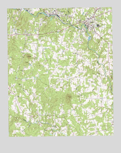
Ramseur, NC USGS Topographic Map
Click on map above to begin viewing in our Map Viewer.

This topographic map contains these locations and features:
Feature Name Type Latitude Longitude GNIS ID View Map
Allen H Leonard Memorial ParkParkN35.7324°W79.6592°1007592View Map
Bethel ChurchChurchN35.6643°W79.7389°981145View Map
Bush CreekStreamN35.7457°W79.7061°982319View Map
Carter LakeReservoirN35.6956°W79.7241°999268View Map
Carter Lake DamDamN35.6951°W79.7248°999269View Map
Cedar Falls Post OfficePost OfficeN35.7327°W79.7410°2774319View Map
Dakota Air Ranch AirportAirportN35.6512°W79.6499°2787159View Map
Eastside Volunteer Fire Protection Association Station 2BuildingN35.6452°W79.7124°2638362View Map
Eastside Volunteer Fire Protection Association Station 3BuildingN35.6816°W79.7390°2639242View Map
Fox MountainSummitN35.7031°W79.7257°985360View Map
FranklinvillePopulated PlaceN35.7437°W79.6923°1020358View Map
Franklinville Elementary SchoolSchoolN35.7474°W79.6931°1006757View Map
Franklinville Fire Department Station 8BuildingN35.7444°W79.6933°2638439View Map
Franklinville Post OfficePost OfficeN35.7474°W79.6947°2774336View Map
Gospel ChurchChurchN35.7237°W79.7236°985854View Map
Holly Springs ChurchChurchN35.6707°W79.6678°986963View Map
Iron MountainSummitN35.6974°W79.7292°1020896View Map
Mill CreekStreamN35.6846°W79.6342°989925View Map
Millstone CreekStreamN35.6776°W79.6278°990033View Map
Mount Taber ChurchChurchN35.6890°W79.7323°990580View Map
Old Salem CemeteryCemeteryN35.7415°W79.6739°991602View Map
Panther CreekStreamN35.6365°W79.7242°1014210View Map
Pilot MountainSummitN35.6632°W79.6784°992213View Map
Pleasant Cross ChurchChurchN35.7254°W79.7270°992453View Map
Pleasant Ridge ChurchChurchN35.7054°W79.6678°992564View Map
Pugh Field (historical)AirportN35.7335°W79.7298°997962View Map
RamseurPopulated PlaceN35.7335°W79.6525°1022142View Map
Ramseur Elementary SchoolSchoolN35.7390°W79.6528°1006756View Map
Ramseur LakeReservoirN35.7335°W79.6564°999320View Map
Ramseur Lake DamDamN35.7335°W79.6564°999319View Map
Ramseur Police DepartmentBuildingN35.7323°W79.6539°2769758View Map
Ramseur Post OfficePost OfficeN35.7330°W79.6547°2773983View Map
Ramseur Volunteer Fire DepartmentBuildingN35.7331°W79.6496°2638518View Map
Randolph Mill DamDamN35.7436°W79.7030°999334View Map
Randolph Mill LakeReservoirN35.7435°W79.7031°999335View Map
Reed CreekStreamN35.7079°W79.6459°993155View Map
Sandy CreekStreamN35.7321°W79.6717°994260View Map
Sandy RunStreamN35.6846°W79.6403°994326View Map
Smith Air StripAirportN35.6348°W79.7127°2679114View Map
Spoons ChapelChurchN35.6762°W79.7350°995312View Map
Squirrel CreekStreamN35.6390°W79.7167°1015766View Map
Stouts ChapelChurchN35.6646°W79.6642°995593View Map
Sunset Knolls CemeteryCemeteryN35.7315°W79.6497°1007591View Map
Town of FranklinvilleCivilN35.7421°W79.6892°2406522View Map
Town of RamseurCivilN35.7375°W79.6545°2407172View Map
Township of GrantCivilN35.6547°W79.7378°1027082View Map

Note: Coordinates in the location and feature list above are referenced to NAD83 datum.


Copyright (C) 2008-2024 Ryan Niemi / Sunset Dynamics ... All Rights Reserved