TopoQuest Logo
Do you find TopoQuest useful?
Help keep TopoQuest running and adding new maps/features by donating!
Bitcoin:  19c7KJd3qBynnjoSw5npx9KScwjBe4ifkT
Litecoin:  LXs6TkuXGGXo1vDsWCkWVdjQX94eUKd6ui
Home View Maps Find Maps Find Places Resources & Links


Star, North Carolina Topographic Map

USGS Map Title: Star, NC
USGS Map MRC: 35079D7
DRG (GeoTIFF) Download: o35079d7.tif


Neighboring USGS Topographic Map Quads:


  Eleazer, NC  
35079E8
 

  Seagrove, NC  
35079E7
 

  Erect, NC  
35079E6
 

  Lovejoy, NC  
35079D8
 

  Star, NC  
35079D7
 

  Spies, NC  
35079D6
 

  Troy, NC  
35079C8
 

  Biscoe, NC  
35079C7
 

  Candor, NC  
35079C6


Map MRC Location:

N36°
W80°
N36°
W79°
H8 H7 H6 H5 H4 H3 H2 H1
G8 G7 G6 G5 G4 G3 G2 G1
F8 F7 F6 F5 F4 F3 F2 F1
E8 E7 E6 E5 E4 E3 E2 E1
D8 D7 D6 D5 D4 D3 D2 D1
C8 C7 C6 C5 C4 C3 C2 C1
B8 B7 B6 B5 B4 B3 B2 B1
A8 A7 A6 A5 A4 A3 A2 A1
N35°
W80°
N35°
W79°

Star, NC USGS 1:24K Topographic Map Preview:
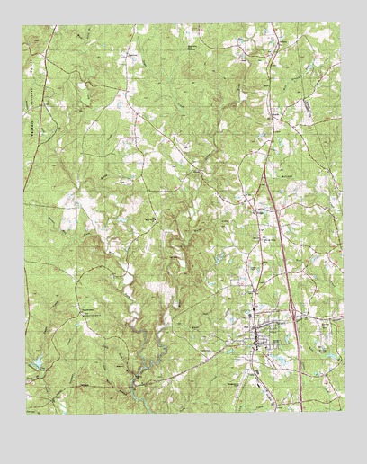
Star, NC USGS Topographic Map
Click on map above to begin viewing in our Map Viewer.

This topographic map contains these locations and features:
Feature Name Type Latitude Longitude GNIS ID View Map
Allen CemeteryCemeteryN35.4251°W79.8148°1017805View Map
AllredsPopulated PlaceN35.4532°W79.8056°1024501View Map
AsburyPopulated PlaceN35.4937°W79.7739°1018856View Map
Asbury ChurchChurchN35.4901°W79.7767°1008787View Map
Barnes Mill CreekStreamN35.4301°W79.8431°1023804View Map
Betsy BranchStreamN35.4949°W79.8503°1009231View Map
Black Ankle MineMineN35.4912°W79.8103°1009427View Map
Black Rock BranchStreamN35.3868°W79.8323°1009447View Map
Dicks CreekStreamN35.3754°W79.8259°1023947View Map
Emergency Medical Rescue SquadBuildingN35.3979°W79.7836°2720662View Map
EtherPopulated PlaceN35.4399°W79.7839°1023962View Map
Ether Post OfficePost OfficeN35.4401°W79.7843°2774264View Map
Forks of Little River ChurchChurchN35.4068°W79.8517°1017806View Map
Foster PondReservoirN35.4368°W79.8381°1017203View Map
Foster Pond DamDamN35.4368°W79.8381°1017202View Map
Gold Mine BranchStreamN35.3810°W79.8334°1011550View Map
Green Grove ChurchChurchN35.3949°W79.8056°1011699View Map
Hughs CreekStreamN35.3932°W79.8698°1012270View Map
Lick CreekStreamN35.3754°W79.7509°1024084View Map
Lick CreekStreamN35.3785°W79.8034°1024085View Map
Montgomery County AirportAirportN35.3880°W79.7880°1024426View Map
New Hope CemeteryCemeteryN35.3951°W79.7559°1013920View Map
New Hope ChurchChurchN35.4021°W79.7584°1013923View Map
Nichols RunStreamN35.4604°W79.8637°1024187View Map
OkeewemeePopulated PlaceN35.4076°W79.8539°1024197View Map
Ott LakeReservoirN35.3835°W79.7681°1017181View Map
Ott Lake DamDamN35.3835°W79.7681°1017182View Map
Rocky CreekStreamN35.4462°W79.8423°1024272View Map
Shady Grove ChurchChurchN35.4368°W79.8237°1015374View Map
Southern Correctional InstitutionBuildingN35.3795°W79.8717°2769861View Map
StarPopulated PlaceN35.4021°W79.7842°1015791View Map
Star Fire DepartmentBuildingN35.3930°W79.7847°2638567View Map
Star Middle SchoolSchoolN35.3954°W79.7839°1017623View Map
Star Police DepartmentBuildingN35.3930°W79.7846°2769575View Map
Star Post OfficePost OfficeN35.3986°W79.7839°2774036View Map
SteedsPopulated PlaceN35.4710°W79.7775°1015806View Map
Suck BranchStreamN35.3874°W79.8684°1024329View Map
Suggs CreekStreamN35.4632°W79.8003°1024333View Map
Suggs Creek ChurchChurchN35.4899°W79.8339°1015940View Map
Town of StarCivilN35.3991°W79.7833°2406660View Map
Township of Little RiverCivilN35.4636°W79.8464°1026959View Map
Township of StarCivilN35.4233°W79.7820°1026964View Map
Troy ReservoirsReservoirN35.3921°W79.8696°1017184View Map
Troy Reservoirs DamDamN35.3918°W79.8698°1017183View Map
Wards CreekStreamN35.4301°W79.8106°1024389View Map
West Fork Little RiverStreamN35.3901°W79.8281°1024401View Map
White Oak CreekStreamN35.4038°W79.8200°1024404View Map
White Oak Springs ChurchChurchN35.4304°W79.7814°1016588View Map

Note: Coordinates in the location and feature list above are referenced to NAD83 datum.


Copyright (C) 2008-2025 Ryan Niemi / Sunset Dynamics ... All Rights Reserved