TopoQuest Logo
Do you find TopoQuest useful?
Help keep TopoQuest running and adding new maps/features by donating!
Bitcoin:  19c7KJd3qBynnjoSw5npx9KScwjBe4ifkT
Litecoin:  LXs6TkuXGGXo1vDsWCkWVdjQX94eUKd6ui
Home View Maps Find Maps Find Places Resources & Links


Seagrove, North Carolina Topographic Map

USGS Map Title: Seagrove, NC
USGS Map MRC: 35079E7
DRG (GeoTIFF) Download: o35079e7.tif


Neighboring USGS Topographic Map Quads:


  Farmer, NC  
35079F8
 

  Asheboro, NC  
35079F7
 

  Ramseur, NC  
35079F6
 

  Eleazer, NC  
35079E8
 

  Seagrove, NC  
35079E7
 

  Erect, NC  
35079E6
 

  Lovejoy, NC  
35079D8
 

  Star, NC  
35079D7
 

  Spies, NC  
35079D6


Map MRC Location:

N36°
W80°
N36°
W79°
H8 H7 H6 H5 H4 H3 H2 H1
G8 G7 G6 G5 G4 G3 G2 G1
F8 F7 F6 F5 F4 F3 F2 F1
E8 E7 E6 E5 E4 E3 E2 E1
D8 D7 D6 D5 D4 D3 D2 D1
C8 C7 C6 C5 C4 C3 C2 C1
B8 B7 B6 B5 B4 B3 B2 B1
A8 A7 A6 A5 A4 A3 A2 A1
N35°
W80°
N35°
W79°

Seagrove, NC USGS 1:24K Topographic Map Preview:
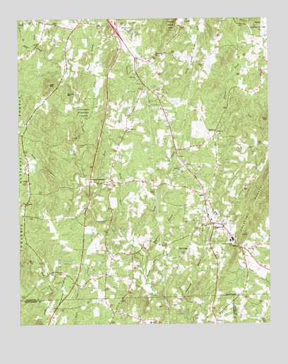
Seagrove, NC USGS Topographic Map
Click on map above to begin viewing in our Map Viewer.

This topographic map contains these locations and features:
Feature Name Type Latitude Longitude GNIS ID View Map
Antioch ChurchChurchN35.6010°W79.8164°1008751View Map
Asheworth BranchStreamN35.5068°W79.7948°1008800View Map
Auman LakeReservoirN35.5707°W79.8483°1017238View Map
Auman Lake DamDamN35.5701°W79.8464°1017239View Map
Aumans CrossroadsPopulated PlaceN35.5587°W79.8392°1008816View Map
Bell BranchStreamN35.6137°W79.8650°1009159View Map
Big BranchStreamN35.5957°W79.8459°1009272View Map
Big Oak Christian ChurchChurchN35.5007°W79.8064°1009346View Map
Black AnklePopulated PlaceN35.5021°W79.8073°1957821View Map
Blacks LakeReservoirN35.5679°W79.8239°1017236View Map
Blacks Lake DamDamN35.5668°W79.8231°1017237View Map
Cagle CemeteryCemeteryN35.5007°W79.7523°1009897View Map
Center Cross ChurchChurchN35.5201°W79.8311°1010146View Map
Emmanuel ChurchChurchN35.5632°W79.7942°1011087View Map
Fairview ChurchChurchN35.5310°W79.7575°1011136View Map
Flag Springs ChurchChurchN35.6104°W79.8067°1011239View Map
Fulp ChurchChurchN35.5529°W79.7831°1011414View Map
Huldah ChurchChurchN35.5785°W79.7759°1012272View Map
Hurley LakeReservoirN35.5751°W79.8614°1017240View Map
Hurley Lake DamDamN35.5751°W79.8614°1017241View Map
Kies MountainSummitN35.5990°W79.8598°1021033View Map
Kings CreekStreamN35.5346°W79.8181°1012634View Map
Maple Springs ChurchChurchN35.5307°W79.7906°1013319View Map
MichfieldPopulated PlaceN35.5782°W79.7767°1021422View Map
Mitchell ChurchChurchN35.6237°W79.7911°1013635View Map
Nancys MountainSummitN35.5946°W79.8503°1021601View Map
Needhams MountainSummitN35.5365°W79.7639°1021610View Map
New Hope ChurchChurchN35.5801°W79.8203°1013926View Map
PisgahPopulated PlaceN35.5499°W79.8712°1014483View Map
Pisgah ChurchChurchN35.5587°W79.8700°1014485View Map
Pleasant Hill ChurchChurchN35.5571°W79.8289°1014523View Map
Reed CreekStreamN35.5515°W79.8386°1014804View Map
Reedy CreekStreamN35.5576°W79.8456°1014810View Map
Rocky CreekStreamN35.5424°W79.8278°1015037View Map
Scott BranchStreamN35.6160°W79.8720°1015332View Map
SeagrovePopulated PlaceN35.5404°W79.7731°1020072View Map
Seagrove Elementary SchoolSchoolN35.5449°W79.7759°1017640View Map
Seagrove Post OfficePost OfficeN35.5427°W79.7805°2774353View Map
Seagrove Volunteer Fire DepartmentBuildingN35.5411°W79.7746°2638602View Map
Slacks LakeReservoirN35.5353°W79.7524°1017223View Map
Slacks Lake DamDamN35.5351°W79.7514°1017224View Map
South Prong Little RiverStreamN35.6107°W79.8592°1015708View Map
Southwestern Randolph High SchoolSchoolN35.6249°W79.8698°1017639View Map
Town of SeagroveCivilN35.5398°W79.7791°2407304View Map
Township of UnionCivilN35.5597°W79.8742°1027093View Map
Wagners BranchStreamN35.5276°W79.8117°1016386View Map
Wesley Dean BranchStreamN35.5168°W79.8106°1016512View Map
WhynotLocaleN35.5310°W79.7636°1016647View Map
Whynot CemeteryCemeteryN35.5315°W79.7589°1957825View Map
Wimbish LakeReservoirN35.5253°W79.8351°1017218View Map
Wimbish Lake DamDamN35.5251°W79.8331°1017219View Map

Note: Coordinates in the location and feature list above are referenced to NAD83 datum.


Copyright (C) 2008-2025 Ryan Niemi / Sunset Dynamics ... All Rights Reserved