TopoQuest Logo
Do you find TopoQuest useful?
Help keep TopoQuest running and adding new maps/features by donating!
Bitcoin:  19c7KJd3qBynnjoSw5npx9KScwjBe4ifkT
Litecoin:  LXs6TkuXGGXo1vDsWCkWVdjQX94eUKd6ui
Home View Maps Find Maps Find Places Resources & Links


Eadytown, South Carolina Topographic Map

USGS Map Title: Eadytown, SC
USGS Map MRC: 33080D2
DRG (GeoTIFF) Download: o33080d2.tif


Neighboring USGS Topographic Map Quads:


  Summerton, SC  
33080E3
 

  Jordan, SC  
33080E2
 

  Butlers Bay, SC  
33080E1
 

  Eutawville, SC  
33080D3
 

  Eadytown, SC  
33080D2
 

  Pineville, SC  
33080D1
 

  Sandridge, SC  
33080C3
 

  Cross, SC  
33080C2
 

  Chicora, SC  
33080C1


Map MRC Location:

N34°
W81°
N34°
W80°
H8 H7 H6 H5 H4 H3 H2 H1
G8 G7 G6 G5 G4 G3 G2 G1
F8 F7 F6 F5 F4 F3 F2 F1
E8 E7 E6 E5 E4 E3 E2 E1
D8 D7 D6 D5 D4 D3 D2 D1
C8 C7 C6 C5 C4 C3 C2 C1
B8 B7 B6 B5 B4 B3 B2 B1
A8 A7 A6 A5 A4 A3 A2 A1
N33°
W81°
N33°
W80°

Eadytown, SC USGS 1:24K Topographic Map Preview:
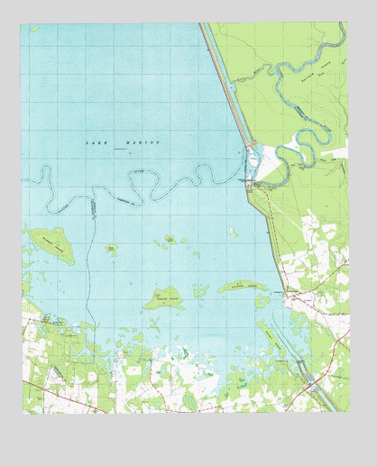
Eadytown, SC USGS Topographic Map
Click on map above to begin viewing in our Map Viewer.

This topographic map contains these locations and features:
Feature Name Type Latitude Longitude GNIS ID View Map
Bass IslandIslandN33.4279°W80.2159°1220352View Map
Bethel ChurchChurchN33.4068°W80.1351°1234273View Map
Bethel School (historical)SchoolN33.4068°W80.1351°1234274View Map
Blackoak Island (historical)IslandN33.4627°W80.1887°1235888View Map
Bluefield CemeteryCemeteryN33.4474°W80.1554°1220822View Map
Cherry Grove Swamp (historical)SwampN33.3974°W80.1726°1234288View Map
Chimney IslandIslandN33.4163°W80.1670°1221568View Map
Church IslandIslandN33.4118°W80.1943°1221596View Map
Corsada (historical)Populated PlaceN33.3807°W80.1962°1234290View Map
Dead End Church (historical)ChurchN33.4121°W80.1490°1234294View Map
EadytownPopulated PlaceN33.4124°W80.1470°1247585View Map
Eadytown Fire Department Company 13BuildingN33.4150°W80.1370°2368070View Map
Folly Pond School (historical)SchoolN33.3793°W80.1523°1234302View Map
Gaillard IslandIslandN33.4846°W80.1367°1222623View Map
Greenland ChurchChurchN33.4110°W80.1423°1245839View Map
Greenland Swamp (historical)SwampN33.4341°W80.1637°1234313View Map
Hickory Hill ChurchChurchN33.4113°W80.1468°1223139View Map
Hickory Hill School (historical)SchoolN33.4035°W80.1459°1234316View Map
Irvin Lake (historical)LakeN33.4402°W80.2151°1234322View Map
Little RiverStreamN33.4849°W80.1526°1224031View Map
Moss Pond (historical)Populated PlaceN33.3807°W80.1448°1234343View Map
Mount Pleasant Plantation CemeteryCemeteryN33.3815°W80.2084°1234346View Map
Pine Grove Lake (historical)LakeN33.4957°W80.2456°1235993View Map
Pine IslandIslandN33.4307°W80.1934°1225459View Map
Pintail IslandIslandN33.3985°W80.1543°1225509View Map
Richardson School (historical)SchoolN33.3802°W80.2345°1706239View Map
Rock Pond CampgroundLocaleN33.4007°W80.2312°1242807View Map
Rocks CemeteryCemeteryN33.3802°W80.2420°1225952View Map
Rocks CemeteryCemeteryN33.4132°W80.1992°1225953View Map
Rocks Church (historical)ChurchN33.4121°W80.1993°1234372View Map
Rocks Creek (historical)StreamN33.4413°W80.2054°1234373View Map
Rocks Creek School (historical)SchoolN33.4141°W80.2145°1251766View Map
Saint Lukes Church (historical)ChurchN33.4210°W80.1281°1234378View Map
Saint Matthews ChurchChurchN33.3766°W80.2226°1226213View Map
Santee DamDamN33.4542°W80.1639°1226397View Map
Sixteen IslandIslandN33.4296°W80.2373°1226657View Map
South Carolina Noname 14016 DamDamN33.4918°W80.1781°1238642View Map
Spring Plain (historical)Populated PlaceN33.3768°W80.1779°1234394View Map
Springwood Swamp (historical)SwampN33.4003°W80.1332°1234396View Map
Thomas Walter GraveCemeteryN33.4540°W80.1431°1234401View Map
Unity ChurchChurchN33.3827°W80.2423°1227315View Map
Unity Church (historical)ChurchN33.4141°W80.2143°1234653View Map
West ChapelChurchN33.3774°W80.1481°1227483View Map
Wilsons LandingPopulated PlaceN33.4485°W80.1618°1231930View Map

Note: Coordinates in the location and feature list above are referenced to NAD83 datum.


Copyright (C) 2008-2025 Ryan Niemi / Sunset Dynamics ... All Rights Reserved