TopoQuest Logo
Do you find TopoQuest useful?
Help keep TopoQuest running and adding new maps/features by donating!
Bitcoin:  19c7KJd3qBynnjoSw5npx9KScwjBe4ifkT
Litecoin:  LXs6TkuXGGXo1vDsWCkWVdjQX94eUKd6ui
Home View Maps Find Maps Find Places Resources & Links


Exeland, Wisconsin Topographic Map

USGS Map Title: Exeland, WI
USGS Map MRC: 45091F2
DRG (GeoTIFF) Download: o45091f2.tif


Neighboring USGS Topographic Map Quads:


  Couderay, WI  
45091G3
 

  Radisson, WI  
45091G2
 

  Winter, WI  
45091G1
 

  Weirgor, WI  
45091F3
 

  Exeland, WI  
45091F2
 

  Hogsback Creek, WI  
45091F1
 

  Becky Creek, WI  
45091E3
 

  Crane, WI  
45091E2
 

  Exeland SE, WI  
45091E1


Map MRC Location:

N46°
W92°
N46°
W91°
H8 H7 H6 H5 H4 H3 H2 H1
G8 G7 G6 G5 G4 G3 G2 G1
F8 F7 F6 F5 F4 F3 F2 F1
E8 E7 E6 E5 E4 E3 E2 E1
D8 D7 D6 D5 D4 D3 D2 D1
C8 C7 C6 C5 C4 C3 C2 C1
B8 B7 B6 B5 B4 B3 B2 B1
A8 A7 A6 A5 A4 A3 A2 A1
N45°
W92°
N45°
W91°

Exeland, WI USGS 1:24K Topographic Map Preview:
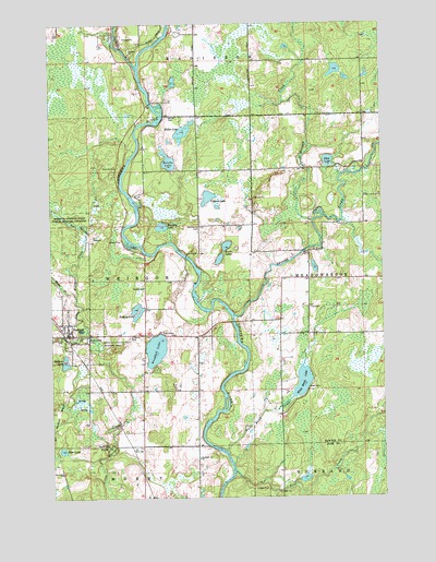
Exeland, WI USGS Topographic Map
Click on map above to begin viewing in our Map Viewer.

This topographic map contains these locations and features:
Feature Name Type Latitude Longitude GNIS ID View Map
Balsam LakeLakeN45.6609°W91.2451°1561141View Map
Balsam Ridge School (historical)SchoolN45.7397°W91.1324°1833735View Map
Bass LakeLakeN45.6376°W91.2464°1561252View Map
Bellile CemeteryCemeteryN45.7255°W91.2057°1561540View Map
Bellisle Falls School (historical)SchoolN45.7261°W91.2057°1833737View Map
Boribo LakeLakeN45.7138°W91.2054°1562078View Map
Brunet Methodist ChurchChurchN45.6866°W91.1532°1833742View Map
Brunet RiverStreamN45.6727°W91.1815°1578868View Map
Brunette School (historical)SchoolN45.6750°W91.1527°1833743View Map
Couderay RiverStreamN45.7388°W91.2171°1563432View Map
ExelandPopulated PlaceN45.6680°W91.2440°1564783View Map
Exeland CemeteryCemeteryN45.6675°W91.2210°1564784View Map
Exeland ChurchChurchN45.6352°W91.1952°1564785View Map
Exeland ChurchChurchN45.6805°W91.2154°1564786View Map
Exeland Elementary SchoolSchoolN45.6683°W91.2443°1833751View Map
Exeland Fire Protection DistrictBuildingN45.6704°W91.2442°2696974View Map
Hess LakeLakeN45.7135°W91.1452°1566334View Map
Jacques LakeLakeN45.6734°W91.2173°1567087View Map
Kenyon CreekStreamN45.6977°W91.1515°1567423View Map
Maple CreekStreamN45.6783°W91.2407°1568963View Map
Meadowbrook TownhallBuildingN45.6750°W91.1527°1833776View Map
Mennonite CemeteryCemeteryN45.6966°W91.1946°1569339View Map
Miller LakeLakeN45.7215°W91.1995°1569517View Map
Murphy LakeLakeN45.6965°W91.2082°1570045View Map
Nail CreekStreamN45.6322°W91.1818°1570096View Map
Reppert School (historical)SchoolN45.7116°W91.1938°1833789View Map
Riverside School (historical)SchoolN45.7189°W91.1315°1833790View Map
South LakesLakeN45.6879°W91.1866°1574462View Map
Swan CreekStreamN45.6677°W91.2354°1575161View Map
Swan Creek ParkParkN45.6669°W91.2363°1575162View Map
Town of WeirgorCivilN45.6828°W91.2354°1584393View Map
Village of ExelandCivilN45.6670°W91.2425°1583181View Map
Villard LakeLakeN45.7042°W91.1905°1576099View Map
Weirgor Springs State Public Hunting GroundsParkN45.6980°W91.2440°1576403View Map
White Birch CreekStreamN45.6369°W91.1849°1576623View Map
White Birch LakeLakeN45.6554°W91.1558°1576625View Map
Windfall LakeLakeN45.6641°W91.2110°1576853View Map
Windfall School (historical)SchoolN45.6611°W91.2140°1833813View Map

Note: Coordinates in the location and feature list above are referenced to NAD83 datum.


Copyright (C) 2008-2025 Ryan Niemi / Sunset Dynamics ... All Rights Reserved