TopoQuest Logo
Do you find TopoQuest useful?
Help keep TopoQuest running and adding new maps/features by donating!
Bitcoin:  19c7KJd3qBynnjoSw5npx9KScwjBe4ifkT
Litecoin:  LXs6TkuXGGXo1vDsWCkWVdjQX94eUKd6ui
Home View Maps Find Maps Find Places Resources & Links


Radisson, Wisconsin Topographic Map

USGS Map Title: Radisson, WI
USGS Map MRC: 45091G2
DRG (GeoTIFF) Download: o45091g2.tif


Neighboring USGS Topographic Map Quads:


  Chief Lake, WI  
45091H3
 

  New Post, WI  
45091H2
 

  Barker Lake, WI  
45091H1
 

  Couderay, WI  
45091G3
 

  Radisson, WI  
45091G2
 

  Winter, WI  
45091G1
 

  Weirgor, WI  
45091F3
 

  Exeland, WI  
45091F2
 

  Hogsback Creek, WI  
45091F1


Map MRC Location:

N46°
W92°
N46°
W91°
H8 H7 H6 H5 H4 H3 H2 H1
G8 G7 G6 G5 G4 G3 G2 G1
F8 F7 F6 F5 F4 F3 F2 F1
E8 E7 E6 E5 E4 E3 E2 E1
D8 D7 D6 D5 D4 D3 D2 D1
C8 C7 C6 C5 C4 C3 C2 C1
B8 B7 B6 B5 B4 B3 B2 B1
A8 A7 A6 A5 A4 A3 A2 A1
N45°
W92°
N45°
W91°

Radisson, WI USGS 1:24K Topographic Map Preview:
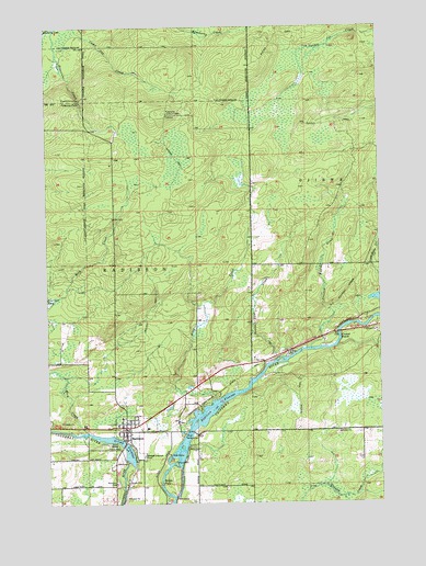
Radisson, WI USGS Topographic Map
Click on map above to begin viewing in our Map Viewer.

This topographic map contains these locations and features:
Feature Name Type Latitude Longitude GNIS ID View Map
Arpin 2WP 329 DamDamN45.7600°W91.2018°1793066View Map
Arpin DamDamN45.7602°W91.2024°1560957View Map
Bellile FallsFallsN45.7550°W91.2079°1561541View Map
Crooked RapidsRapidsN45.7936°W91.1407°1563551View Map
Crooked Rapids CreekStreamN45.7905°W91.1532°1563552View Map
Grimh FlowageReservoirN45.7626°W91.2196°1565905View Map
Grimh WP 370 DamDamN45.7608°W91.2207°1791768View Map
Hemlock Spur CreekStreamN45.7888°W91.1585°1566293View Map
King CreekStreamN45.7769°W91.1891°1567495View Map
Pipestone CampLocaleN45.8563°W91.2371°1571559View Map
Pipestone FallsFallsN45.8552°W91.2368°1571560View Map
Pipestone Lookout TowerTowerN45.8525°W91.2046°1581319View Map
RadissonPopulated PlaceN45.7688°W91.2213°1572019View Map
Radisson CemeteryCemeteryN45.7552°W91.2249°1572020View Map
Radisson Elementary SchoolSchoolN45.7725°W91.2227°1833788View Map
Radisson FlowageReservoirN45.7725°W91.1926°1572021View Map
Radisson Volunteer Fire DepartmentBuildingN45.7692°W91.2180°2696945View Map
Rock CreekStreamN45.7686°W91.2354°1572437View Map
Town of RadissonCivilN45.7894°W91.2002°1583993View Map
Village of RadissonCivilN45.7683°W91.2179°1583992View Map

Note: Coordinates in the location and feature list above are referenced to NAD83 datum.


Copyright (C) 2008-2024 Ryan Niemi / Sunset Dynamics ... All Rights Reserved