TopoQuest Logo
Do you find TopoQuest useful?
Help keep TopoQuest running and adding new maps/features by donating!
Bitcoin:  19c7KJd3qBynnjoSw5npx9KScwjBe4ifkT
Litecoin:  LXs6TkuXGGXo1vDsWCkWVdjQX94eUKd6ui
Home View Maps Find Maps Find Places Resources & Links


Fair Bluff, North Carolina Topographic Map

USGS Map Title: Fair Bluff, NC
USGS Map MRC: 34079C1
DRG (GeoTIFF) Download: o34079c1.tif


Neighboring USGS Topographic Map Quads:


  Gaddysville, NC  
34079D2
 

  Fairmont, NC  
34079D1
 

  Evergreen, NC  
34078D8
 

  Lake View, SC  
34079C2
 

  Fair Bluff, NC  
34079C1
 

  Cerro Gordo, NC  
34078C8
 

  Nichols, SC  
34079B2
 

  Duford, SC  
34079B1
 

  Tabor City West, NC  
34078B8


Map MRC Location:

N35°
W80°
N35°
W79°
H8 H7 H6 H5 H4 H3 H2 H1
G8 G7 G6 G5 G4 G3 G2 G1
F8 F7 F6 F5 F4 F3 F2 F1
E8 E7 E6 E5 E4 E3 E2 E1
D8 D7 D6 D5 D4 D3 D2 D1
C8 C7 C6 C5 C4 C3 C2 C1
B8 B7 B6 B5 B4 B3 B2 B1
A8 A7 A6 A5 A4 A3 A2 A1
N34°
W80°
N34°
W79°

Fair Bluff, NC USGS 1:24K Topographic Map Preview:
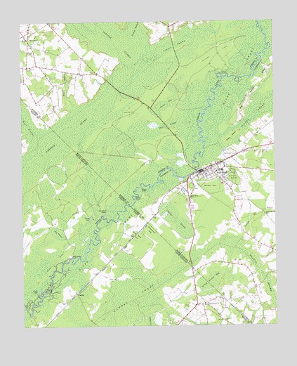
Fair Bluff, NC USGS Topographic Map
Click on map above to begin viewing in our Map Viewer.

This topographic map contains these locations and features:
Feature Name Type Latitude Longitude GNIS ID View Map
Ashpole SwampSwampN34.3249°W79.1064°1244937View Map
Barden BaySwampN34.3079°W79.0320°980545View Map
Bear SwampStreamN34.3268°W79.1170°1220412View Map
Big Sandy RidgeRidgeN34.3435°W79.0120°1025155View Map
Big ThickSwampN34.2879°W79.1075°1220741View Map
Buck Head BayBasinN34.2871°W79.0681°1221073View Map
Bush IslandIslandN34.3266°W79.0211°982320View Map
Butler Branch Baptist ChurchChurchN34.3166°W79.0245°2505915View Map
CauseyPopulated PlaceN34.2635°W79.0981°1227879View Map
Coleman Mill BranchStreamN34.2854°W79.0173°1025250View Map
Coward SwampSwampN34.3638°W79.0464°983649View Map
Cypress BranchSwampN34.3104°W79.0203°983880View Map
Cypress Branch ChurchChurchN34.2957°W79.0050°983881View Map
Deadman LakesLakeN34.2966°W79.0838°1221961View Map
Devils ElbowBendN34.3029°W79.0695°984145View Map
Fair BluffPopulated PlaceN34.3135°W79.0373°1020187View Map
Fair Bluff Baptist ChurchChurchN34.3121°W79.0396°2505885View Map
Fair Bluff Elementary SchoolSchoolN34.3138°W79.0256°1006499View Map
Fair Bluff Fire DepartmentBuildingN34.3127°W79.0355°2638511View Map
Fair Bluff Police DepartmentBuildingN34.3133°W79.0368°2130944View Map
Fair Bluff Post OfficePost OfficeN34.3136°W79.0358°2505363View Map
Fair Bluff Rescue SquadBuildingN34.3126°W79.0357°2720391View Map
Fair Bluff Wastewater Treatment PlantLocaleN34.3159°W79.0409°2506002View Map
Flat SwampSwampN34.3324°W79.0520°985193View Map
Floyd LakeLakeN34.2947°W79.0913°1222468View Map
Gapway SwampSwampN34.2621°W79.0703°1247869View Map
Gapway SwampSwampN34.2813°W79.0175°985549View Map
Green BaySwampN34.3410°W79.0517°986042View Map
Griffin CemeteryCemeteryN34.2868°W79.0706°1222908View Map
Griffin CemeteryCemeteryN34.3252°W79.0156°986149View Map
Hammon CemeteryCemeteryN34.2599°W79.1056°1223001View Map
Hammond CemeteryCemeteryN34.2527°W79.0256°1223006View Map
Heron LakesLakeN34.3068°W79.0657°986650View Map
Hickory Grove Baptist ChurchChurchN34.2628°W79.0144°2506153View Map
Horne SwampSwampN34.2935°W79.0489°987069View Map
Indian SwampStreamN34.3710°W79.0764°987369View Map
Jordan CreekStreamN34.2543°W79.0634°1246208View Map
MariettaPopulated PlaceN34.3688°W79.1223°989338View Map
Marietta CemeteryCemeteryN34.3563°W79.1209°989339View Map
Marietta Post OfficePost OfficeN34.3690°W79.1220°2774311View Map
Marietta Township (historical)CivilN34.3685°W79.1228°1027110View Map
Meares CemeteryCemeteryN34.3202°W79.0214°989691View Map
Mill BranchStreamN34.3407°W79.0989°989860View Map
Parker CemeteryCemeteryN34.2696°W79.0823°1225300View Map
Powell CemeteryCemeteryN34.3071°W79.0467°992768View Map
River SwampSwampN34.3160°W79.0461°993378View Map
Sandy Grove ChurchChurchN34.3029°W79.0417°994273View Map
Sawscalpel BayBasinN34.2891°W79.0611°1226427View Map
Sawscalpel BayBayN34.2891°W79.0611°994396View Map
Sellers FieldFlatN34.3616°W79.0281°994493View Map
Spring Branch BaySwampN34.2652°W79.0370°1226812View Map
Spring Branch BaySwampN34.2674°W79.0323°995325View Map
Spring Branch ChurchChurchN34.2591°W79.0350°1250996View Map
Spring Branch School (historical)SchoolN34.2588°W79.0339°1243971View Map
Strickland FieldAirportN34.2683°W79.0224°2679169View Map
Sundays LandingLocaleN34.3535°W79.0253°1022839View Map
Town of Fair BluffCivilN34.3126°W79.0333°2406477View Map
Town of MariettaCivilN34.3682°W79.1249°2406097View Map
Township of Fair BluffCivilN34.2984°W79.0034°1026576View Map
Turner ChapelChurchN34.3629°W79.1209°996358View Map
Watermelon BluffCliffN34.2779°W79.0998°1227430View Map
White LakeLakeN34.2653°W79.1170°1227537View Map
WWKO-AM (Fair Bluff)TowerN34.3232°W79.0017°1018357View Map

Note: Coordinates in the location and feature list above are referenced to NAD83 datum.


Copyright (C) 2008-2024 Ryan Niemi / Sunset Dynamics ... All Rights Reserved