TopoQuest Logo
Do you find TopoQuest useful?
Help keep TopoQuest running and adding new maps/features by donating!
Bitcoin:  19c7KJd3qBynnjoSw5npx9KScwjBe4ifkT
Litecoin:  LXs6TkuXGGXo1vDsWCkWVdjQX94eUKd6ui
Home View Maps Find Maps Find Places Resources & Links


Fairmount, Texas Topographic Map

USGS Map Title: Fairmount, TX
USGS Map MRC: 31093B6
DRG (GeoTIFF) Download: o31093b6.tif


Neighboring USGS Topographic Map Quads:


  Hemphill, TX  
31093C7
 

  Negreet SW, TX  
31093C6
 

  Toro, LA  
31093C5
 

  Hurricane Creek, TX  
31093B7
 

  Fairmount, TX  
31093B6
 

  Haddens, LA  
31093B5
 

  Weeks Settlement, TX  
31093A7
 

  Wiergate, TX  
31093A6
 

  Wiergate SE, TX  
31093A5


Map MRC Location:

N32°
W94°
N32°
W93°
H8 H7 H6 H5 H4 H3 H2 H1
G8 G7 G6 G5 G4 G3 G2 G1
F8 F7 F6 F5 F4 F3 F2 F1
E8 E7 E6 E5 E4 E3 E2 E1
D8 D7 D6 D5 D4 D3 D2 D1
C8 C7 C6 C5 C4 C3 C2 C1
B8 B7 B6 B5 B4 B3 B2 B1
A8 A7 A6 A5 A4 A3 A2 A1
N31°
W94°
N31°
W93°

Fairmount, TX USGS 1:24K Topographic Map Preview:
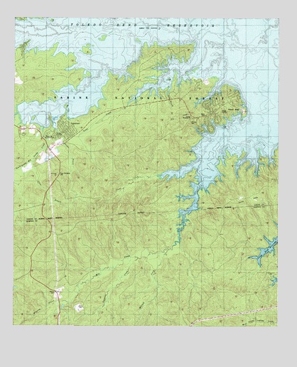
Fairmount, TX USGS Topographic Map
Click on map above to begin viewing in our Map Viewer.

This topographic map contains these locations and features:
Feature Name Type Latitude Longitude GNIS ID View Map
Big Sandy CreekStreamN31.2482°W93.6946°1381431View Map
Buck CreekStreamN31.1530°W93.6393°1384845View Map
Clark-Dickey CemeteryCemeteryN31.1969°W93.7419°2575490View Map
Clear BranchStreamN31.1916°W93.7421°1381651View Map
Clear CreekStreamN31.1932°W93.6607°1381658View Map
Copperas CreekStreamN31.1530°W93.6916°1381698View Map
FairdalePopulated PlaceN31.2305°W93.6618°1381856View Map
Fairmont Volunteer Fire DepartmentBuildingN31.2150°W93.6886°2655507View Map
FairmountPopulated PlaceN31.1969°W93.7332°1381857View Map
Fairmount CemeteryCemeteryN31.2046°W93.7380°1381858View Map
Fox Hunters HillSummitN31.1863°W93.7291°1381893View Map
Hickory RidgePopulated PlaceN31.2127°W93.6421°1381999View Map
Hickory Ridge SpringsSpringN31.2252°W93.6585°1998360View Map
Long BranchStreamN31.2246°W93.6785°1382194View Map
Miles CreekStreamN31.2469°W93.7152°1382285View Map
Mill Creek CemeteryCemeteryN31.1717°W93.6639°2575524View Map
Mitchell CreekStreamN31.1560°W93.6766°1382311View Map
Mount Sinai CemeteryCemeteryN31.2094°W93.6643°1382352View Map
Sand HillsSummitN31.1755°W93.6416°1382699View Map
Sandy BranchStreamN31.2019°W93.6346°1382702View Map
Sandy BranchStreamN31.2438°W93.7293°1382705View Map
Shingle BranchStreamN31.2155°W93.7288°1382757View Map
South Prong CreekStreamN31.2035°W93.7363°1382783View Map
Watering BranchStreamN31.1341°W93.7235°1382925View Map
Weaver CemeteryCemeteryN31.1391°W93.7302°1382927View Map

Note: Coordinates in the location and feature list above are referenced to NAD83 datum.


Copyright (C) 2008-2025 Ryan Niemi / Sunset Dynamics ... All Rights Reserved