TopoQuest Logo
Do you find TopoQuest useful?
Help keep TopoQuest running and adding new maps/features by donating!
Bitcoin:  19c7KJd3qBynnjoSw5npx9KScwjBe4ifkT
Litecoin:  LXs6TkuXGGXo1vDsWCkWVdjQX94eUKd6ui
Home View Maps Find Maps Find Places Resources & Links


Negreet SW, Texas Topographic Map

USGS Map Title: Negreet SW, TX
USGS Map MRC: 31093C6
DRG (GeoTIFF) Download: o31093c6.tif


Neighboring USGS Topographic Map Quads:


  Milam, TX  
31093D7
 

  Salter Creek, LA  
31093D6
 

  Negreet, LA  
31093D5
 

  Hemphill, TX  
31093C7
 

  Negreet SW, TX  
31093C6
 

  Toro, LA  
31093C5
 

  Hurricane Creek, TX  
31093B7
 

  Fairmount, TX  
31093B6
 

  Haddens, LA  
31093B5


Map MRC Location:

N32°
W94°
N32°
W93°
H8 H7 H6 H5 H4 H3 H2 H1
G8 G7 G6 G5 G4 G3 G2 G1
F8 F7 F6 F5 F4 F3 F2 F1
E8 E7 E6 E5 E4 E3 E2 E1
D8 D7 D6 D5 D4 D3 D2 D1
C8 C7 C6 C5 C4 C3 C2 C1
B8 B7 B6 B5 B4 B3 B2 B1
A8 A7 A6 A5 A4 A3 A2 A1
N31°
W94°
N31°
W93°

Negreet SW, TX USGS 1:24K Topographic Map Preview:
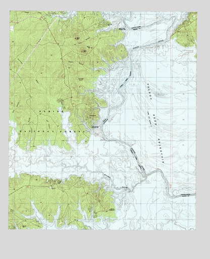
Negreet SW, TX USGS Topographic Map
Click on map above to begin viewing in our Map Viewer.

This topographic map contains these locations and features:
Feature Name Type Latitude Longitude GNIS ID View Map
Arthurs LakeLakeN31.2802°W93.6507°1381279View Map
Ashmore BranchStreamN31.2882°W93.7346°1381338View Map
Bar LakeLakeN31.3149°W93.6671°553344View Map
Bar Lake School (historical)SchoolN31.3196°W93.6613°546075View Map
Big BranchStreamN31.2888°W93.7257°1381418View Map
Black LakeLakeN31.3088°W93.6805°553684View Map
Blackland SloughGutN31.2974°W93.6338°553703View Map
Blackmail BranchStreamN31.3205°W93.6816°1381454View Map
Bull CreekStreamN31.2888°W93.7480°1381550View Map
Bull CreekStreamN31.2891°W93.7474°1383048View Map
Columbus (historical)Populated PlaceN31.3546°W93.6532°546095View Map
Coma CreekStreamN31.3743°W93.7277°1383068View Map
Crane Pond (historical)LakeN31.3630°W93.6588°1381283View Map
Cutoff LakeLakeN31.3057°W93.6824°554154View Map
Cutoff Pond (historical)LakeN31.3180°W93.6857°1381284View Map
Ferry LakeLakeN31.2724°W93.6368°554395View Map
Godwins Ferry (historical)CrossingN31.3210°W93.6766°557920View Map
Gordon ShoalsBarN31.3613°W93.6452°546116View Map
Green Lake (historical)LakeN31.2732°W93.6257°546118View Map
Grocer LakeLakeN31.2741°W93.6421°554626View Map
Gum LakeLakeN31.2994°W93.6627°554631View Map
Gum Slough (historical)GutN31.3363°W93.6432°546119View Map
Harpers Bend (historical)BendN31.3699°W93.6413°1381288View Map
Hegren BranchStreamN31.3421°W93.6685°1381986View Map
Housen BayouStreamN31.2838°W93.6605°1383109View Map
Hurricane BayouStreamN31.2866°W93.7038°1382051View Map
Indian Mounds WildernessReserveN31.3402°W93.7418°1383775View Map
Isaac Low CemeteryCemeteryN31.3677°W93.6849°1382206View Map
Lowes CreekStreamN31.2535°W93.6485°1382207View Map
McCartney LakeLakeN31.2746°W93.6332°555258View Map
McCord CemeteryCemeteryN31.2519°W93.7408°2575548View Map
Moss HillSummitN31.3541°W93.6952°1382329View Map
Oak Hill CemeteryCemeteryN31.2742°W93.7219°2575529View Map
Oak Hill ChurchChurchN31.2738°W93.7213°1382410View Map
Oil Well BranchStreamN31.3713°W93.6730°1382421View Map
Robertson Ferry (historical)CrossingN31.2738°W93.6441°546163View Map
Rock HillSummitN31.3596°W93.7049°1382633View Map
Sabine Lookout TowerTowerN31.2669°W93.6888°1384659View Map
Saint James Church (historical)ChurchN31.3191°W93.6657°557923View Map
Saint Johns Church (historical)ChurchN31.3194°W93.6610°546172View Map
Saint Mary Church (historical)ChurchN31.2921°W93.6288°546175View Map
Sand HillSummitN31.3521°W93.7002°1382698View Map
Sixmile CreekStreamN31.2502°W93.6635°1383187View Map
Sixmile CreekStreamN31.2505°W93.6252°1383188View Map
Spate LakeLakeN31.3269°W93.6716°556107View Map
Tom Self LakeLakeN31.2882°W93.6488°556254View Map
Willow PondLakeN31.2810°W93.6438°556444View Map

Note: Coordinates in the location and feature list above are referenced to NAD83 datum.


Copyright (C) 2008-2025 Ryan Niemi / Sunset Dynamics ... All Rights Reserved