TopoQuest Logo
Do you find TopoQuest useful?
Help keep TopoQuest running and adding new maps/features by donating!
Bitcoin:  19c7KJd3qBynnjoSw5npx9KScwjBe4ifkT
Litecoin:  LXs6TkuXGGXo1vDsWCkWVdjQX94eUKd6ui
Home View Maps Find Maps Find Places Resources & Links


Wiergate, Texas Topographic Map

USGS Map Title: Wiergate, TX
USGS Map MRC: 31093A6
DRG (GeoTIFF) Download: o31093a6.tif


Neighboring USGS Topographic Map Quads:


  Hurricane Creek, TX  
31093B7
 

  Fairmount, TX  
31093B6
 

  Haddens, LA  
31093B5
 

  Weeks Settlement, TX  
31093A7
 

  Wiergate, TX  
31093A6
 

  Wiergate SE, TX  
31093A5
 

  Jamestown, TX  
30093H7
 

  Shankleville, TX  
30093H6
 

  Evans, LA  
30093H5


Map MRC Location:

N32°
W94°
N32°
W93°
H8 H7 H6 H5 H4 H3 H2 H1
G8 G7 G6 G5 G4 G3 G2 G1
F8 F7 F6 F5 F4 F3 F2 F1
E8 E7 E6 E5 E4 E3 E2 E1
D8 D7 D6 D5 D4 D3 D2 D1
C8 C7 C6 C5 C4 C3 C2 C1
B8 B7 B6 B5 B4 B3 B2 B1
A8 A7 A6 A5 A4 A3 A2 A1
N31°
W94°
N31°
W93°

Wiergate, TX USGS 1:24K Topographic Map Preview:
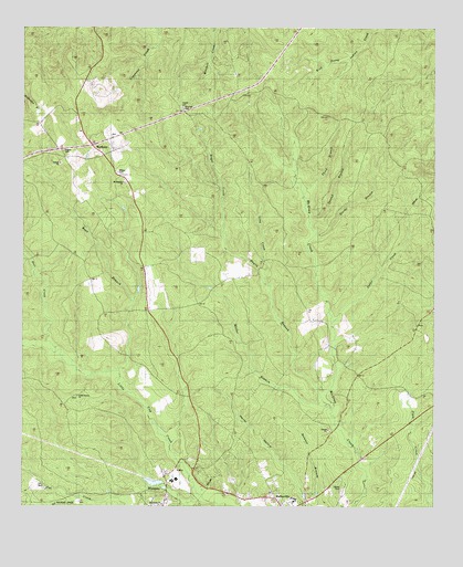
Wiergate, TX USGS Topographic Map
Click on map above to begin viewing in our Map Viewer.

This topographic map contains these locations and features:
Feature Name Type Latitude Longitude GNIS ID View Map
Bayou BranchStreamN31.0282°W93.6585°1351628View Map
Bear BranchStreamN31.0346°W93.7213°1351658View Map
Burkeville DivisionCivilN31.0632°W93.7048°1938581View Map
Deer CreekStreamN31.0421°W93.7441°1355848View Map
Eddie Gatson CemeteryCemeteryN31.0288°W93.7335°1356811View Map
Faith ChapelChurchN31.0021°W93.6843°1357199View Map
Jeeter CreekStreamN31.0477°W93.6552°1360193View Map
Long CreekStreamN31.0610°W93.6763°1361719View Map
Macedonia ChurchChurchN31.0027°W93.7088°1362026View Map
Mattox CemeteryCemeteryN31.0874°W93.7210°1362055View Map
MayflowerPopulated PlaceN31.0945°W93.7294°1380159View Map
Miller BranchStreamN31.0271°W93.6577°1362887View Map
Mitchell CemeteryCemeteryN31.1041°W93.7007°1362991View Map
Mount Pleasant ChurchChurchN31.0846°W93.7191°1363310View Map
Plum SchoolSchoolN31.0344°W93.6574°1365487View Map
Royal CreekStreamN31.0610°W93.6763°1366985View Map
Second Branch McGraw CreekStreamN31.0746°W93.6632°1367915View Map
Smith LakeReservoirN31.0064°W93.7093°1864509View Map
Smith Lake DamDamN31.0052°W93.7085°1864508View Map
Starks BranchStreamN31.0705°W93.6621°1369125View Map
Survey SchoolSchoolN31.0866°W93.7196°1369432View Map
Tanner CemeteryCemeteryN31.0046°W93.6530°1369598View Map
Third Branch McGraw CreekStreamN31.0794°W93.6638°1369830View Map
Wiergate Post OfficePost OfficeN31.0078°W93.7070°2731544View Map

Note: Coordinates in the location and feature list above are referenced to NAD83 datum.


Copyright (C) 2008-2025 Ryan Niemi / Sunset Dynamics ... All Rights Reserved