TopoQuest Logo
Do you find TopoQuest useful?
Help keep TopoQuest running and adding new maps/features by donating!
Bitcoin:  19c7KJd3qBynnjoSw5npx9KScwjBe4ifkT
Litecoin:  LXs6TkuXGGXo1vDsWCkWVdjQX94eUKd6ui
Home View Maps Find Maps Find Places Resources & Links


Fandon, Illinois Topographic Map

USGS Map Title: Fandon, IL
USGS Map MRC: 40090C7
DRG (GeoTIFF) Download: o40090c7.tif


Neighboring USGS Topographic Map Quads:


  Fountain Green, IL  
40090D8
 

  Colchester, IL  
40090D7
 

  Macomb, IL  
40090D6
 

  Plymouth, IL  
40090C8
 

  Fandon, IL  
40090C7
 

  Doddsville, IL  
40090C6
 

  Augusta, IL  
40090B8
 

  Camden, IL  
40090B7
 

  Erwin, IL  
40090B6


Map MRC Location:

N41°
W91°
N41°
W90°
H8 H7 H6 H5 H4 H3 H2 H1
G8 G7 G6 G5 G4 G3 G2 G1
F8 F7 F6 F5 F4 F3 F2 F1
E8 E7 E6 E5 E4 E3 E2 E1
D8 D7 D6 D5 D4 D3 D2 D1
C8 C7 C6 C5 C4 C3 C2 C1
B8 B7 B6 B5 B4 B3 B2 B1
A8 A7 A6 A5 A4 A3 A2 A1
N40°
W91°
N40°
W90°

Fandon, IL USGS 1:24K Topographic Map Preview:
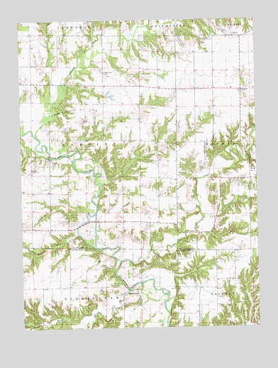
Fandon, IL USGS Topographic Map
Click on map above to begin viewing in our Map Viewer.

This topographic map contains these locations and features:
Feature Name Type Latitude Longitude GNIS ID View Map
Archer-Bethel CemeteryCemeteryN40.3639°W90.7562°1824300View Map
Beckford BranchStreamN40.2878°W90.8446°404077View Map
BirminghamPopulated PlaceN40.2642°W90.8210°422466View Map
Buncombe School (historical)SchoolN40.2923°W90.8068°1721190View Map
Camp CreekStreamN40.2773°W90.8232°405451View Map
Camp Creek Church of the Brethren (historical)ChurchN40.3287°W90.7824°1721191View Map
Clark AirportAirportN40.3260°W90.8251°427696View Map
Colmar-Plymouth Oil FieldOilfieldN40.3378°W90.8601°424768View Map
Cow Ford BridgeBridgeN40.2912°W90.8451°1721201View Map
Dowacter Airport (historical)AirportN40.3139°W90.8718°427698View Map
Duncan Church (historical)ChurchN40.3484°W90.8312°1721204View Map
Dunkard CemeteryCemeteryN40.3289°W90.7829°407500View Map
Dunsworth CemeteryCemeteryN40.3528°W90.7743°1954734View Map
Eagle Community ChurchChurchN40.3134°W90.7510°407561View Map
Eagle Free Methodist Church (historical)ChurchN40.3134°W90.7510°1824352View Map
Eagle School (historical)SchoolN40.3137°W90.7510°1721205View Map
East School (historical)SchoolN40.3048°W90.8593°1721207View Map
FandonPopulated PlaceN40.3684°W90.7615°408266View Map
Fandon Christian ChurchChurchN40.3678°W90.7632°1824359View Map
Fandon School (historical)SchoolN40.3695°W90.7640°1824360View Map
Flour CreekStreamN40.2667°W90.8057°408476View Map
Gibson CemeteryCemeteryN40.3670°W90.7751°408989View Map
Grindstone CreekStreamN40.2937°W90.7793°409517View Map
Guinea School (historical)SchoolN40.2653°W90.7729°1720682View Map
Hogwallow BranchStreamN40.2917°W90.8446°410367View Map
Lamoine BridgeBridgeN40.3195°W90.8604°1721227View Map
Lamoine Chapel (historical)ChurchN40.3128°W90.8601°1721228View Map
Miler GraveCemeteryN40.3700°W90.7665°1824421View Map
Noel CemeteryCemeteryN40.2609°W90.8229°414543View Map
Prather CemeteryCemeteryN40.2598°W90.7618°416186View Map
Scott CemeteryCemeteryN40.2995°W90.7923°1824465View Map
Scott ChurchChurchN40.2987°W90.7924°418142View Map
Shanghai School (historical)SchoolN40.3098°W90.7929°1721256View Map
Stookey School (historical)SchoolN40.3342°W90.8312°1721257View Map
Sullivan CemeteryCemeteryN40.3475°W90.7562°1954765View Map
Township of LamoineCivilN40.3261°W90.8506°429228View Map
Troublesome CreekStreamN40.3281°W90.8665°419889View Map
Warmack CemeteryCemeteryN40.3477°W90.7505°1954745View Map
Waymack CemeteryCemeteryN40.3478°W90.7504°1954746View Map
West Bethel Baptist ChurchChurchN40.3462°W90.7568°404311View Map
West Bethel School (historical)SchoolN40.3417°W90.7715°1721264View Map
White Flock CemeteryCemeteryN40.3536°W90.8301°421038View Map
White Flock Congregational Church (historical)ChurchN40.3487°W90.8118°1824505View Map
White Flock School (historical)SchoolN40.3531°W90.8129°1721266View Map
Williams CreekStreamN40.2509°W90.8418°421203View Map

Note: Coordinates in the location and feature list above are referenced to NAD83 datum.


Copyright (C) 2008-2024 Ryan Niemi / Sunset Dynamics ... All Rights Reserved