TopoQuest Logo
Do you find TopoQuest useful?
Help keep TopoQuest running and adding new maps/features by donating!
Bitcoin:  19c7KJd3qBynnjoSw5npx9KScwjBe4ifkT
Litecoin:  LXs6TkuXGGXo1vDsWCkWVdjQX94eUKd6ui
Home View Maps Find Maps Find Places Resources & Links


Camden, Illinois Topographic Map

USGS Map Title: Camden, IL
USGS Map MRC: 40090B7
DRG (GeoTIFF) Download: o40090b7.tif


Neighboring USGS Topographic Map Quads:


  Plymouth, IL  
40090C8
 

  Fandon, IL  
40090C7
 

  Doddsville, IL  
40090C6
 

  Augusta, IL  
40090B8
 

  Camden, IL  
40090B7
 

  Erwin, IL  
40090B6
 

  Clayton, IL  
40090A8
 

  Lake Mount Sterling, IL  
40090A7
 

  Ripley, IL  
40090A6


Map MRC Location:

N41°
W91°
N41°
W90°
H8 H7 H6 H5 H4 H3 H2 H1
G8 G7 G6 G5 G4 G3 G2 G1
F8 F7 F6 F5 F4 F3 F2 F1
E8 E7 E6 E5 E4 E3 E2 E1
D8 D7 D6 D5 D4 D3 D2 D1
C8 C7 C6 C5 C4 C3 C2 C1
B8 B7 B6 B5 B4 B3 B2 B1
A8 A7 A6 A5 A4 A3 A2 A1
N40°
W91°
N40°
W90°

Camden, IL USGS 1:24K Topographic Map Preview:
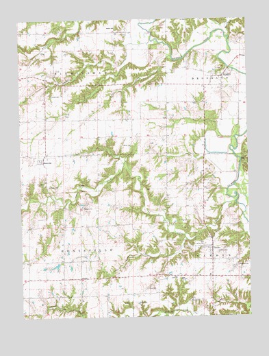
Camden, IL USGS Topographic Map
Click on map above to begin viewing in our Map Viewer.

This topographic map contains these locations and features:
Feature Name Type Latitude Longitude GNIS ID View Map
BrooklynPopulated PlaceN40.2259°W90.7632°404911View Map
Brooklyn CemeteryCemeteryN40.2286°W90.7651°1984427View Map
Brooklyn Post Office (historical)Post OfficeN40.2256°W90.7657°1821122View Map
CamdenPopulated PlaceN40.1537°W90.7707°405422View Map
Camden Post OfficePost OfficeN40.1523°W90.7708°2788502View Map
Cane Hill School (historical)SchoolN40.1634°W90.8187°405548View Map
Cedar CreekStreamN40.1734°W90.7568°405735View Map
Center Grove School (historical)SchoolN40.1484°W90.8426°405791View Map
Center School (historical)SchoolN40.2328°W90.8562°405817View Map
Clay BankCliffN40.1917°W90.7524°1720661View Map
Cox CemeteryCemeteryN40.2495°W90.7826°406689View Map
Croxton LakeReservoirN40.1467°W90.8562°1692545View Map
Croxton Lake DamDamN40.1484°W90.8551°1692544View Map
Fairview School (historical)SchoolN40.2045°W90.7949°408220View Map
Farwell CemeteryCemeteryN40.2184°W90.8571°1720669View Map
Gillespie CemeteryCemeteryN40.1312°W90.8118°1720678View Map
Harrison BranchStreamN40.2409°W90.8029°409854View Map
HuntsvillePopulated PlaceN40.1912°W90.8646°410702View Map
Huntsville CemeteryCemeteryN40.1803°W90.8601°410703View Map
Huntsville Post OfficePost OfficeN40.1920°W90.8635°1821134View Map
Joey Eaton GraveCemeteryN40.1978°W90.8035°1984486View Map
Jordan School (historical)SchoolN40.1778°W90.7837°411253View Map
King CemeteryCemeteryN40.1654°W90.7839°411488View Map
King CemeteryCemeteryN40.1817°W90.8662°1720693View Map
Lambert MineMineN40.1753°W90.7957°1967413View Map
Lewis CreekStreamN40.2345°W90.7912°411972View Map
Liberty School (historical)SchoolN40.2445°W90.8176°412029View Map
Little Cedar CreekStreamN40.1578°W90.7851°412301View Map
Markee CemeteryCemeteryN40.2464°W90.8221°413017View Map
McHatton CemeteryCemeteryN40.1524°W90.7676°1720700View Map
Mecum CemeteryCemeteryN40.1970°W90.8143°1720702View Map
MindalePopulated PlaceN40.1417°W90.8429°1720703View Map
Musick PondReservoirN40.2250°W90.8168°1692525View Map
Musick Pond DamDamN40.2250°W90.8168°1692524View Map
Nebo School (historical)SchoolN40.1350°W90.8124°414331View Map
North Cady CemeteryCemeteryN40.1423°W90.7907°1720708View Map
Pettijohn GraveCemeteryN40.1709°W90.8410°1720712View Map
Pit 17 Cedar Creek MineMineN40.1606°W90.8335°1967411View Map
Pit 18 Cedar Creek MineMineN40.1714°W90.8332°1967412View Map
Pit 2 Cedar Creek MineMineN40.1431°W90.7637°1967580View Map
Pit 3 Cedar Creek MineMineN40.1398°W90.7640°1967581View Map
Pit 4 Cedar Creek MineMineN40.1378°W90.8335°1967408View Map
Pit 6 Cedar Creek MineMineN40.1442°W90.8179°1967409View Map
Pit 8 Cedar Creek MineMineN40.1462°W90.8360°1967410View Map
Plunkett CemeteryCemeteryN40.1320°W90.7785°1720715View Map
Prunty CemeteryCemeteryN40.1371°W90.8065°1720717View Map
Reeder MineMineN40.1481°W90.7590°1967591View Map
Shiloh ChurchChurchN40.1492°W90.8426°1720731View Map
South Cady CemeteryCemeteryN40.1409°W90.7885°1720733View Map
South Prairie School (historical)SchoolN40.1492°W90.8729°418816View Map
Township of BirminghamCivilN40.2381°W90.8527°428675View Map
Township of HuntsvilleCivilN40.1492°W90.8542°429157View Map
Union School (historical)SchoolN40.2087°W90.8176°420119View Map
Village of CamdenCivilN40.1528°W90.7733°2397540View Map
Waitman CemeteryCemeteryN40.1468°W90.7561°420381View Map
Weightman CemeteryCemeteryN40.1465°W90.7565°1720746View Map
West Camden CemeteryCemeteryN40.1556°W90.7751°1720748View Map
Willow CreekStreamN40.2428°W90.7601°421241View Map

Note: Coordinates in the location and feature list above are referenced to NAD83 datum.


Copyright (C) 2008-2025 Ryan Niemi / Sunset Dynamics ... All Rights Reserved