TopoQuest Logo
Do you find TopoQuest useful?
Help keep TopoQuest running and adding new maps/features by donating!
Bitcoin:  19c7KJd3qBynnjoSw5npx9KScwjBe4ifkT
Litecoin:  LXs6TkuXGGXo1vDsWCkWVdjQX94eUKd6ui
Home View Maps Find Maps Find Places Resources & Links


Camden, Mississippi Topographic Map

USGS Map Title: Camden, MS
USGS Map MRC: 32089G7
DRG (GeoTIFF) Download: o32089g7.tif


Neighboring USGS Topographic Map Quads:


  Goodman, MS  
32089H8
 

  Newport, MS  
32089H7
 

  Joseph, MS  
32089H6
 

  Cameron, MS  
32089G8
 

  Camden, MS  
32089G7
 

  Thomastown, MS  
32089G6
 

  Sharon, MS  
32089F8
 

  Farmhaven, MS  
32089F7
 

  Ofahoma, MS  
32089F6


Map MRC Location:

N33°
W90°
N33°
W89°
H8 H7 H6 H5 H4 H3 H2 H1
G8 G7 G6 G5 G4 G3 G2 G1
F8 F7 F6 F5 F4 F3 F2 F1
E8 E7 E6 E5 E4 E3 E2 E1
D8 D7 D6 D5 D4 D3 D2 D1
C8 C7 C6 C5 C4 C3 C2 C1
B8 B7 B6 B5 B4 B3 B2 B1
A8 A7 A6 A5 A4 A3 A2 A1
N32°
W90°
N32°
W89°

Camden, MS USGS 1:24K Topographic Map Preview:
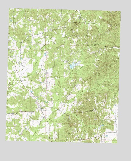
Camden, MS USGS Topographic Map
Click on map above to begin viewing in our Map Viewer.

This topographic map contains these locations and features:
Feature Name Type Latitude Longitude GNIS ID View Map
Bowdens Mill (historical)LocaleN32.7718°W89.8334°683225View Map
CamdenPopulated PlaceN32.7824°W89.8387°667955View Map
Camden CemeteryCemeteryN32.7812°W89.8417°2042946View Map
Camden Post OfficePost OfficeN32.7820°W89.8385°2768647View Map
Camden SchoolSchoolN32.7771°W89.8467°667956View Map
Cedar Hill ChurchChurchN32.7807°W89.7781°668208View Map
Center Consolidated School (historical)SchoolN32.8640°W89.7817°683227View Map
Couparle CemeteryCemeteryN32.8557°W89.8216°2042953View Map
Couparle ChurchChurchN32.8557°W89.8206°668880View Map
Couperle (historical)LocaleN32.8593°W89.8181°690943View Map
David Kernop Lake DamDamN32.8685°W89.7951°681708View Map
Dear CemeteryCemeteryN32.8225°W89.7654°2042955View Map
Goodhope ChurchChurchN32.8629°W89.8020°670496View Map
Great Murphy Chapel CemeteryCemeteryN32.7784°W89.8469°2042969View Map
Greenwood CemeteryCemeteryN32.8221°W89.7648°670718View Map
Greenwood Church (historical)ChurchN32.8221°W89.7640°683241View Map
International Paper Lake DamDamN32.8301°W89.8351°681685View Map
J V Blalock Lake DamDamN32.7901°W89.8401°681656View Map
Joe Cauthen Lake DamDamN32.8501°W89.8584°681699View Map
Kennedy CreekStreamN32.8099°W89.8092°672100View Map
L McMurtry Lake DamDamN32.8051°W89.8351°681665View Map
Madison SpringsSpringN32.8393°W89.8676°683250View Map
Mansell CreekStreamN32.7782°W89.8081°673114View Map
Mansell Lake DamDamN32.8318°W89.8317°681686View Map
Morgans LakeReservoirN32.8227°W89.8018°686110View Map
Morgans Lake DamDamN32.8201°W89.8017°681676View Map
Mount Mary ChurchChurchN32.8615°W89.8692°674055View Map
Mount Zion ChurchChurchN32.8410°W89.7670°674369View Map
Murphy ChapelChurchN32.7785°W89.8459°674481View Map
Old Hebron CemeteryCemeteryN32.7819°W89.7594°2043010View Map
Old Truelight Church CemeteryCemeteryN32.8712°W89.8698°2043014View Map
Partridge Lumber Company Lake DamDamN32.7668°W89.7684°681634View Map
Pleasant Hill Missionary Baptist CemeteryCemeteryN32.8310°W89.8609°2043018View Map
Poorhouse CreekStreamN32.7718°W89.8256°676209View Map
RevivePopulated PlaceN32.7596°W89.7642°692172View Map
Saint Lukes ChurchChurchN32.7754°W89.8656°677116View Map
Shiloh CemeteryCemeteryN32.8429°W89.8606°677665View Map
True Light ChurchChurchN32.8715°W89.8695°678899View Map
Velma Jackson High SchoolSchoolN32.7757°W89.8670°679202View Map
Watermill CreekStreamN32.7718°W89.8256°679369View Map
Wilderwood CemeteryCemeteryN32.7791°W89.8597°2043063View Map

Note: Coordinates in the location and feature list above are referenced to NAD83 datum.


Copyright (C) 2008-2025 Ryan Niemi / Sunset Dynamics ... All Rights Reserved