TopoQuest Logo
Do you find TopoQuest useful?
Help keep TopoQuest running and adding new maps/features by donating!
Bitcoin:  19c7KJd3qBynnjoSw5npx9KScwjBe4ifkT
Litecoin:  LXs6TkuXGGXo1vDsWCkWVdjQX94eUKd6ui
Home View Maps Find Maps Find Places Resources & Links


Thomastown, Mississippi Topographic Map

USGS Map Title: Thomastown, MS
USGS Map MRC: 32089G6
DRG (GeoTIFF) Download: o32089g6.tif


Neighboring USGS Topographic Map Quads:


  Newport, MS  
32089H7
 

  Joseph, MS  
32089H6
 

  Singleton, MS  
32089H5
 

  Camden, MS  
32089G7
 

  Thomastown, MS  
32089G6
 

  Conway, MS  
32089G5
 

  Farmhaven, MS  
32089F7
 

  Ofahoma, MS  
32089F6
 

  Carthage, MS  
32089F5


Map MRC Location:

N33°
W90°
N33°
W89°
H8 H7 H6 H5 H4 H3 H2 H1
G8 G7 G6 G5 G4 G3 G2 G1
F8 F7 F6 F5 F4 F3 F2 F1
E8 E7 E6 E5 E4 E3 E2 E1
D8 D7 D6 D5 D4 D3 D2 D1
C8 C7 C6 C5 C4 C3 C2 C1
B8 B7 B6 B5 B4 B3 B2 B1
A8 A7 A6 A5 A4 A3 A2 A1
N32°
W90°
N32°
W89°

Thomastown, MS USGS 1:24K Topographic Map Preview:
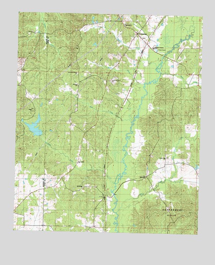
Thomastown, MS USGS Topographic Map
Click on map above to begin viewing in our Map Viewer.

This topographic map contains these locations and features:
Feature Name Type Latitude Longitude GNIS ID View Map
Adcock Family CemeteryCemeteryN32.8514°W89.7408°2042934View Map
Bain CreekStreamN32.8137°W89.6715°666464View Map
Blailock CreekStreamN32.8443°W89.6559°667258View Map
Bourne McGehee DamDamN32.8035°W89.7367°681664View Map
Christian Union ChurchChurchN32.7932°W89.6484°668434View Map
Damascus CemeteryCemeteryN32.8340°W89.7090°691100View Map
Damascus Church (historical)ChurchN32.8346°W89.7084°691139View Map
Hebron ChurchChurchN32.8187°W89.7395°691101View Map
Kernop Family CemeteryCemeteryN32.8635°W89.7409°2042986View Map
Kirkwood (historical)LocaleN32.8557°W89.7376°683247View Map
Kirkwood CemeteryCemeteryN32.8554°W89.7375°2042987View Map
Myric CreekStreamN32.8365°W89.6629°674497View Map
New Jerusalem ChurchChurchN32.7896°W89.7081°674760View Map
Ninemile CreekStreamN32.7785°W89.6817°674925View Map
Old Jerusalem ChurchChurchN32.7760°W89.7037°675197View Map
P B Dickens Catfish Ponds DamDamN32.8718°W89.7001°681713View Map
Pleasant Green ChurchChurchN32.8393°W89.6279°675968View Map
Rambo CreekStreamN32.8724°W89.7337°676462View Map
Saint AnnPopulated PlaceN32.7829°W89.6604°677010View Map
Saint Ann CemeteryCemeteryN32.7829°W89.6606°707153View Map
Shaui Koli CreekStreamN32.7815°W89.6454°677625View Map
Shiola CreekStreamN32.7615°W89.6806°677715View Map
Smith CreekStreamN32.8421°W89.6523°677927View Map
Supervisor District 3CivilN32.7880°W89.6637°711950View Map
ThomastownPopulated PlaceN32.8640°W89.6695°678685View Map
Thomastown Attendance CenterSchoolN32.8560°W89.6584°691144View Map
Thomastown Attendance CenterSchoolN32.8654°W89.6690°707165View Map
Thomastown Baptist CemeteryCemeteryN32.8371°W89.6865°678686View Map
Thomastown Christian CemeteryCemeteryN32.8404°W89.7090°678687View Map
Thomastown Community Post OfficePost OfficeN32.8642°W89.6697°2768738View Map
Thomastown Volunteer Fire DepartmentBuildingN32.8635°W89.6694°2665852View Map
Wake Forest CemeteryCemeteryN32.8685°W89.6776°707170View Map
Wake Forest ChurchChurchN32.8693°W89.6776°679244View Map

Note: Coordinates in the location and feature list above are referenced to NAD83 datum.


Copyright (C) 2008-2024 Ryan Niemi / Sunset Dynamics ... All Rights Reserved